Pinchout Creek Topo Map Montana
To zoom in, hover over the map of Pinchout Creek
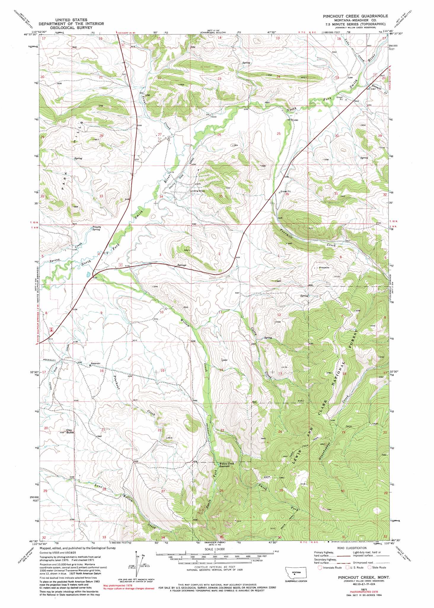
USGS Topo Quad 46110e7 - 1:24,000 scale
| Topo Map Name: | Pinchout Creek |
| USGS Topo Quad ID: | 46110e7 |
| Print Size: | ca. 21 1/4" wide x 27" high |
| Southeast Coordinates: | 46.5° N latitude / 110.75° W longitude |
| Map Center Coordinates: | 46.5625° N latitude / 110.8125° W longitude |
| U.S. State: | MT |
| Filename: | o46110e7.jpg |
| Download Map JPG Image: | Pinchout Creek topo map 1:24,000 scale |
| Map Type: | Topographic |
| Topo Series: | 7.5´ |
| Map Scale: | 1:24,000 |
| Source of Map Images: | United States Geological Survey (USGS) |
| Alternate Map Versions: |
Pinchout Creek MT 1995, updated 1997 Download PDF Buy paper map Pinchout Creek MT 2011 Download PDF Buy paper map Pinchout Creek MT 2014 Download PDF Buy paper map |
| FStopo: | US Forest Service topo Pinchout Creek is available: Download FStopo PDF Download FStopo TIF |
1:24,000 Topo Quads surrounding Pinchout Creek
Sheep Mountain |
Strawberry Butte |
Moose Mountain |
Kings Hill |
Sand Point |
Whitetail Reservoir |
Coxcombe Butte |
Charcoal Gulch |
Volcano Butte |
Hoover Spring |
Hanson Reservoir |
White Sulphur Springs |
Pinchout Creek |
Fourmile Spring |
Checkerboard |
Alkali Lake |
Catlin Spring |
Manger Park |
Castle Town |
Lennep |
Battle Mountain |
Black Butte Mountain |
Ringling |
Hamen |
Rimrock Divide |
> Back to 46110e1 at 1:100,000 scale
> Back to 46110a1 at 1:250,000 scale
> Back to U.S. Topo Maps home
Pinchout Creek topo map: Gazetteer
Pinchout Creek: Canals
South Side Canal elevation 1577m 5173′Pinchout Creek: Mines
Cut Bank Mine elevation 1865m 6118′NW NW Section 19 Mine elevation 1982m 6502′
NW SE Section 23 Mine elevation 1741m 5711′
Ringling Mine elevation 1812m 5944′
Pinchout Creek: Reservoirs
Willow Creek Reservoir elevation 1737m 5698′Pinchout Creek: Springs
Trinity Spring elevation 1562m 5124′Pinchout Creek: Streams
Casey Creek elevation 1613m 5291′Fivemile Creek elevation 1622m 5321′
Fourmile Creek elevation 1609m 5278′
Lake Creek elevation 1635m 5364′
Pinchout Creek elevation 1562m 5124′
Smith Fork elevation 1683m 5521′
South Fork Willow Creek elevation 1683m 5521′
Trout Creek elevation 1582m 5190′
Willow Creek elevation 1545m 5068′
Pinchout Creek: Summits
Clay Butte elevation 1625m 5331′Pinchout Creek: Wells
09N07E04DC__01 Well elevation 1564m 5131′09N07E05AD__01 Well elevation 1557m 5108′
09N07E08AC__01 Well elevation 1550m 5085′
10N07E25C___01 Well elevation 1673m 5488′
10N07E27AC__01 Well elevation 1586m 5203′
10N07E35B___01 Well elevation 1697m 5567′
Pinchout Creek digital topo map on disk
Buy this Pinchout Creek topo map showing relief, roads, GPS coordinates and other geographical features, as a high-resolution digital map file on DVD: