Utica Topo Map Montana
To zoom in, hover over the map of Utica
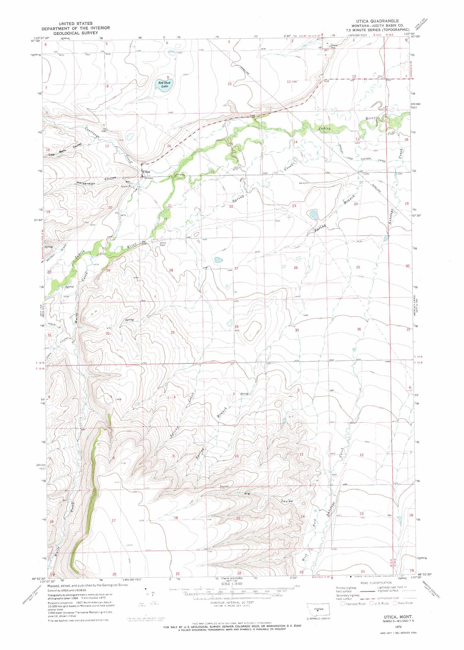
USGS Topo Quad 46110h1 - 1:24,000 scale
| Topo Map Name: | Utica |
| USGS Topo Quad ID: | 46110h1 |
| Print Size: | ca. 21 1/4" wide x 27" high |
| Southeast Coordinates: | 46.875° N latitude / 110° W longitude |
| Map Center Coordinates: | 46.9375° N latitude / 110.0625° W longitude |
| U.S. State: | MT |
| Filename: | o46110h1.jpg |
| Download Map JPG Image: | Utica topo map 1:24,000 scale |
| Map Type: | Topographic |
| Topo Series: | 7.5´ |
| Map Scale: | 1:24,000 |
| Source of Map Images: | United States Geological Survey (USGS) |
| Alternate Map Versions: |
Utica MT 1970, updated 1973 Download PDF Buy paper map Utica MT 2011 Download PDF Buy paper map Utica MT 2014 Download PDF Buy paper map |
1:24,000 Topo Quads surrounding Utica
Merino |
Stanford |
Stanford Ne |
Big Spring |
Harwood Bench |
Cayuse Basin |
Windham |
Benchland |
Moccasin |
Kolin |
Woodhurst Mountain |
Red Hill |
Utica |
Ackley Lake |
Sipple |
Indian Hill |
Browns Canyon |
Twin Sisters |
Martin Coulee |
Buffalo |
Daisy Peak |
Haymaker Narrows |
Jellison Place |
Mead Creek |
Judith Gap |
> Back to 46110e1 at 1:100,000 scale
> Back to 46110a1 at 1:250,000 scale
> Back to U.S. Topo Maps home
Utica topo map: Gazetteer
Utica: Lakes
Red Shed Lake elevation 1376m 4514′Utica: Populated Places
Utica elevation 1364m 4475′Utica: Post Offices
Utica Post Office (historical) elevation 1364m 4475′Utica: Springs
13N13E03AA__02 Spring elevation 1403m 4603′13N13E04BD__01 Spring elevation 1439m 4721′
13N13E04CB__01 Spring elevation 1452m 4763′
13N13E05BD__01 Spring elevation 1489m 4885′
13N13E05CD__01 Spring elevation 1449m 4753′
13N13E08AB__01 Spring elevation 1542m 5059′
13N13E08BA__01 Spring elevation 1501m 4924′
13N13E09CB__01 Spring elevation 1536m 5039′
13N13E10BC__01 Spring elevation 1456m 4776′
13N13E14AB__01 Spring elevation 1441m 4727′
13N13E15AD__01 Spring elevation 1512m 4960′
13N13E15BA__01 Spring elevation 1543m 5062′
14N13E15CC__02 Spring elevation 1349m 4425′
14N13E15CD__01 Spring elevation 1346m 4416′
14N13E22AA__01 Spring elevation 1342m 4402′
14N13E22AA__02 Spring elevation 1342m 4402′
14N13E22AB__01 Spring elevation 1343m 4406′
14N13E22BB__01 Spring elevation 1351m 4432′
14N13E24CB__01 Spring elevation 1341m 4399′
14N13E32CD__01 Spring elevation 1474m 4835′
14N13E33BB__01 Spring elevation 1410m 4625′
Utica: Streams
Antelope Creek elevation 1306m 4284′Courtneys Creek elevation 1352m 4435′
Spring Branch elevation 1321m 4333′
Spring Creek elevation 1322m 4337′
Waite Creek elevation 1373m 4504′
West Fork Antelope Creek elevation 1426m 4678′
Utica: Valleys
Big Coulee elevation 1429m 4688′Coal Bank Coulee elevation 1379m 4524′
Ellis Coulee elevation 1403m 4603′
Heiserman Coulee elevation 1368m 4488′
Utica: Wells
13N13E03AA__01 Well elevation 1403m 4603′13N13E04AADD01 Well elevation 1413m 4635′
13N13E05CC__01 Well elevation 1452m 4763′
13N13E06AA__01 Well elevation 1417m 4648′
13N13E08BB__01 Well elevation 1492m 4895′
13N13E11DD__01 Well elevation 1423m 4668′
13N13E12CC__01 Well elevation 1428m 4685′
13N13E12CC__02 Well elevation 1428m 4685′
13N13E12CC__03 Well elevation 1428m 4685′
13N13E12CC__04 Well elevation 1428m 4685′
13N13E12CC__05 Well elevation 1428m 4685′
13N13E17DC__01 Well elevation 1597m 5239′
14N13E11CCD_01 Well elevation 1336m 4383′
14N13E15CC__01 Well elevation 1349m 4425′
14N13E16CC__01 Well elevation 1361m 4465′
14N13E16CCCD01 Well elevation 1363m 4471′
14N13E19DDC_01 Well elevation 1392m 4566′
14N13E21AA__01 Well elevation 1354m 4442′
14N13E21BBB_01 Well elevation 1362m 4468′
14N13E21DB__01 Well elevation 1358m 4455′
14N13E21DC__01 Well elevation 1360m 4461′
14N13E22AC__01 Well elevation 1347m 4419′
14N13E23BB__01 Well elevation 1340m 4396′
14N13E23BB__02 Well elevation 1340m 4396′
14N13E24AB__01 Well elevation 1332m 4370′
14N13E24BA__01 Well elevation 1332m 4370′
14N13E24BA__02 Well elevation 1332m 4370′
14N13E24BCBA01 Well elevation 1345m 4412′
14N13E24BD__01 Well elevation 1337m 4386′
14N13E26CD__01 Well elevation 1367m 4484′
14N13E26DCBB01 Well elevation 1360m 4461′
14N13E27DC__01 Well elevation 1375m 4511′
14N13E28DD__01 Well elevation 1376m 4514′
14N13E28DD__02 Well elevation 1376m 4514′
14N13E30ABB_01 Well elevation 1395m 4576′
14N13E33ABAD01 Well elevation 1379m 4524′
14N13E33DA__01 Well elevation 1396m 4580′
14N13E35CACC01 Well elevation 1381m 4530′
Utica digital topo map on disk
Buy this Utica topo map showing relief, roads, GPS coordinates and other geographical features, as a high-resolution digital map file on DVD: