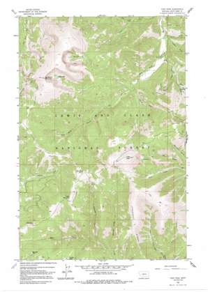
Yogo Peak Topo Map Montana
To zoom in, hover over the map of Yogo Peak
USGS Topo Quad 46110h5 - 1:24,000 scale
| Topo Map Name: | Yogo Peak |
| USGS Topo Quad ID: | 46110h5 |
| Print Size: | ca. 21 1/4" wide x 27" high |
| Southeast Coordinates: | 46.875° N latitude / 110.5° W longitude |
| Map Center Coordinates: | 46.9375° N latitude / 110.5625° W longitude |
| U.S. State: | MT |
| Filename: | o46110h5.jpg |
| Download Map JPG Image: | Yogo Peak topo map 1:24,000 scale |
| Map Type: | Topographic |
| Topo Series: | 7.5´ |
| Map Scale: | 1:24,000 |
| Source of Map Images: | United States Geological Survey (USGS) |
| Alternate Map Versions: |
Yogo Peak MT 1961, updated 1964 Download PDF Buy paper map Yogo Peak MT 1961, updated 1980 Download PDF Buy paper map Yogo Peak MT 1961, updated 1991 Download PDF Buy paper map Yogo Peak MT 1995, updated 1997 Download PDF Buy paper map Yogo Peak MT 1995, updated 1997 Download PDF Buy paper map Yogo Peak MT 2011 Download PDF Buy paper map Yogo Peak MT 2014 Download PDF Buy paper map |
| FStopo: | US Forest Service topo Yogo Peak is available: Download FStopo PDF Download FStopo TIF |
1:24,000 Topo Quads surrounding Yogo Peak
> Back to 46110e1 at 1:100,000 scale
> Back to 46110a1 at 1:250,000 scale
> Back to U.S. Topo Maps home
Yogo Peak topo map: Gazetteer
Yogo Peak: Lakes
Lake Elva elevation 2335m 7660′Rhoda Lake elevation 2517m 8257′
Twin Lakes elevation 2444m 8018′
Yogo Peak: Mines
NE SE Section 36 Mine elevation 2279m 7477′NW NE Section 2 Mine elevation 2386m 7828′
NW NE Section 31 Mine elevation 2290m 7513′
NW SE Section 10 Mine elevation 2289m 7509′
SE SW Section 31 Mine elevation 2166m 7106′
SW SW Section 3 Mine elevation 2419m 7936′
Yogo Peak: Ridges
Prospect Ridge elevation 2377m 7798′Yogo Peak: Streams
Appraisal Creek elevation 1940m 6364′East Fork Stiner Creek elevation 1887m 6190′
Hell Creek elevation 1905m 6250′
Snow Creek elevation 1833m 6013′
West Fork Stiner Creek elevation 1887m 6190′
Yogo Peak: Summits
Big Baldy Mountain elevation 2799m 9183′Big Deer Point elevation 2483m 8146′
Cabin Mountain elevation 2496m 8188′
Coyote Peak elevation 2428m 7965′
Slide Rock Point elevation 2479m 8133′
Tepee Butte elevation 2508m 8228′
Yogo Peak elevation 2686m 8812′
Yogo Peak: Valleys
Flat Gulch elevation 1918m 6292′Gravel Gulch elevation 1755m 5757′
Iron Gulch elevation 1842m 6043′
Lead Gulch elevation 1982m 6502′
Lyons Gulch elevation 1803m 5915′
Rolfe Gulch elevation 1776m 5826′
Silver Gulch elevation 1862m 6108′
Tucken Gulch elevation 1786m 5859′
Yogo Peak digital topo map on disk
Buy this Yogo Peak topo map showing relief, roads, GPS coordinates and other geographical features, as a high-resolution digital map file on DVD:


