Mount Edith Topo Map Montana
To zoom in, hover over the map of Mount Edith
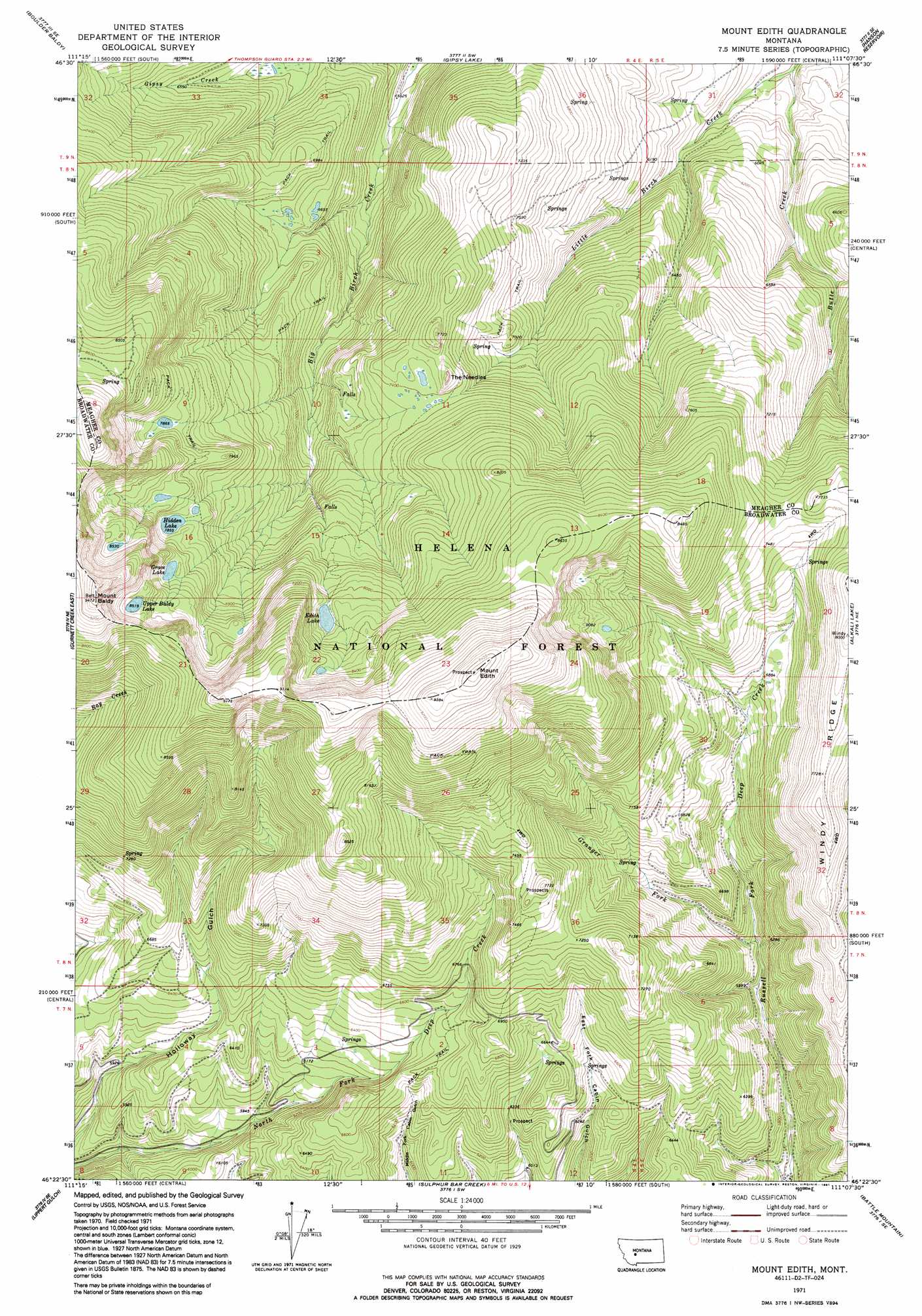
USGS Topo Quad 46111d2 - 1:24,000 scale
| Topo Map Name: | Mount Edith |
| USGS Topo Quad ID: | 46111d2 |
| Print Size: | ca. 21 1/4" wide x 27" high |
| Southeast Coordinates: | 46.375° N latitude / 111.125° W longitude |
| Map Center Coordinates: | 46.4375° N latitude / 111.1875° W longitude |
| U.S. State: | MT |
| Filename: | o46111d2.jpg |
| Download Map JPG Image: | Mount Edith topo map 1:24,000 scale |
| Map Type: | Topographic |
| Topo Series: | 7.5´ |
| Map Scale: | 1:24,000 |
| Source of Map Images: | United States Geological Survey (USGS) |
| Alternate Map Versions: |
Mount Edith MT 1971, updated 1975 Download PDF Buy paper map Mount Edith MT 1971, updated 1985 Download PDF Buy paper map Mount Edith MT 2001, updated 2004 Download PDF Buy paper map Mount Edith MT 2011 Download PDF Buy paper map Mount Edith MT 2014 Download PDF Buy paper map |
| FStopo: | US Forest Service topo Mount Edith is available: Download FStopo PDF Download FStopo TIF |
1:24,000 Topo Quads surrounding Mount Edith
Whites City |
Watson |
Fort Logan |
Whitetail Reservoir |
Coxcombe Butte |
Diamond City |
Boulder Baldy |
Gipsy Lake |
Hanson Reservoir |
White Sulphur Springs |
Gurnett Creek West |
Gurnett Creek East |
Mount Edith |
Alkali Lake |
Catlin Spring |
Holker |
Lippert Gulch |
Sulphur Bar Creek |
Battle Mountain |
Black Butte Mountain |
Toston |
Deer Park |
Sixmile Mountain |
Francis |
Sixteen |
> Back to 46111a1 at 1:100,000 scale
> Back to 46110a1 at 1:250,000 scale
> Back to U.S. Topo Maps home
Mount Edith topo map: Gazetteer
Mount Edith: Lakes
Edith Lake elevation 2442m 8011′Grace Lake elevation 2470m 8103′
Hidden Lake elevation 2395m 7857′
Upper Baldy Lake elevation 2597m 8520′
Mount Edith: Pillars
The Needles elevation 2303m 7555′Mount Edith: Ridges
Windy Ridge elevation 2231m 7319′Mount Edith: Streams
Butte Creek elevation 1701m 5580′Granger Fork elevation 1910m 6266′
Spring Creek elevation 1780m 5839′
Mount Edith: Summits
Mount Baldy elevation 2878m 9442′Mount Edith elevation 2877m 9438′
Mount Edith digital topo map on disk
Buy this Mount Edith topo map showing relief, roads, GPS coordinates and other geographical features, as a high-resolution digital map file on DVD: