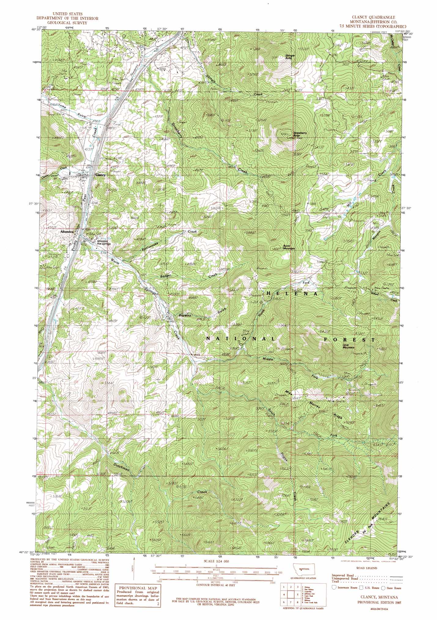
Clancy Topo Map Montana
To zoom in, hover over the map of Clancy
USGS Topo Quad 46111d8 - 1:24,000 scale
| Topo Map Name: | Clancy |
| USGS Topo Quad ID: | 46111d8 |
| Print Size: | ca. 21 1/4" wide x 27" high |
| Southeast Coordinates: | 46.375° N latitude / 111.875° W longitude |
| Map Center Coordinates: | 46.4375° N latitude / 111.9375° W longitude |
| U.S. State: | MT |
| Filename: | o46111d8.jpg |
| Download Map JPG Image: | Clancy topo map 1:24,000 scale |
| Map Type: | Topographic |
| Topo Series: | 7.5´ |
| Map Scale: | 1:24,000 |
| Source of Map Images: | United States Geological Survey (USGS) |
| Alternate Map Versions: |
Clancy MT 1985, updated 1986 Download PDF Buy paper map Clancy MT 2001, updated 2004 Download PDF Buy paper map Clancy MT 2011 Download PDF Buy paper map Clancy MT 2014 Download PDF Buy paper map |
| FStopo: | US Forest Service topo Clancy is available: Download FStopo PDF Download FStopo TIF |
1:24,000 Topo Quads surrounding Clancy
Austin |
Scratchgravel Hill |
Lake Helena |
Hauser Lake |
Canyon Ferry |
Black Mountain |
Helena |
East Helena |
Louisville |
Canyon Ferry Sw |
Chessman Reservoir |
Jefferson City |
Clancy |
Casey Peak |
Winston |
Mount Thompson |
Wickes |
Elkhorn |
Crow Creek Falls |
Giant Hill |
Boulder West |
Boulder East |
Tacoma Park |
Devils Fence |
Radersburg |
> Back to 46111a1 at 1:100,000 scale
> Back to 46110a1 at 1:250,000 scale
> Back to U.S. Topo Maps home
Clancy topo map: Gazetteer
Clancy: Crossings
Interchange 182 elevation 1290m 4232′Clancy: Flats
Elk Park elevation 2297m 7536′Clancy: Mines
Alhambra Hot Springs Mine elevation 1335m 4379′Argonaut Mine elevation 1446m 4744′
B and G Mine elevation 1798m 5898′
Champion Mine elevation 1380m 4527′
Eagles Nest Mine elevation 1771m 5810′
Forest Park Mine elevation 1381m 4530′
Mid Fork Warm Springs Mine elevation 1653m 5423′
NE NE Section 18 Mine elevation 1653m 5423′
NW SW Section 24 Mine elevation 1527m 5009′
Wall 2 Mine elevation 1301m 4268′
Clancy: Populated Places
Alhambra elevation 1305m 4281′Clancy elevation 1293m 4242′
Lewiston (historical) elevation 1297m 4255′
New Haven (historical) elevation 1302m 4271′
Clancy: Post Offices
Alhambra Post Office (historical) elevation 1305m 4281′Clancy Post Office elevation 1293m 4242′
Lump Post Office (historical) elevation 1293m 4242′
Clancy: Ranges
Elkhorn Mountains elevation 1507m 4944′Clancy: Reservoirs
Scott Reservoir elevation 1522m 4993′Clancy: Ridges
Mike Murray Ridge elevation 1760m 5774′Clancy: Springs
08N03W16ACA_01 Spring elevation 1312m 4304′08N03W16ACAA01 Spring elevation 1322m 4337′
08N03W16ACD_01 Spring elevation 1349m 4425′
Clancy: Streams
Badger Creek elevation 1339m 4393′Clancy Creek elevation 1288m 4225′
Dutchman Creek elevation 1318m 4324′
Haystack Creek elevation 1413m 4635′
Hogan Creek elevation 1628m 5341′
Middle Fork Warm Springs Creek elevation 1452m 4763′
Mill Creek elevation 1528m 5013′
North Fork Warm Springs Creek elevation 1389m 4557′
Rattlesnake Creek elevation 1321m 4333′
Shingle Creek elevation 1257m 4124′
South Fork Warm Springs Creek elevation 1389m 4557′
Strawberry Creek elevation 1269m 4163′
Warm Springs Creek elevation 1303m 4274′
Clancy: Summits
Burnt Mountain elevation 1834m 6017′Lava Mountain elevation 1976m 6482′
Shingle Butte elevation 1803m 5915′
Strawberry Butte elevation 1856m 6089′
Clancy: Valleys
Browns Gulch elevation 1370m 4494′Lump Gulch elevation 1279m 4196′
Clancy: Wells
08N03W16AAB_01 Well elevation 1326m 4350′08N03W16AAC_01 Well elevation 1326m 4350′
08N03W16ABB_01 Well elevation 1328m 4356′
08N03W16ACBC01 Well elevation 1311m 4301′
08N03W16ADB_01 Well elevation 1313m 4307′
08N03W16ADD_01 Well elevation 1314m 4311′
08N03W16BDA_01 Well elevation 1306m 4284′
08N03W22ACA_01 Well elevation 1369m 4491′
Clancy digital topo map on disk
Buy this Clancy topo map showing relief, roads, GPS coordinates and other geographical features, as a high-resolution digital map file on DVD: