Diamond City Topo Map Montana
To zoom in, hover over the map of Diamond City
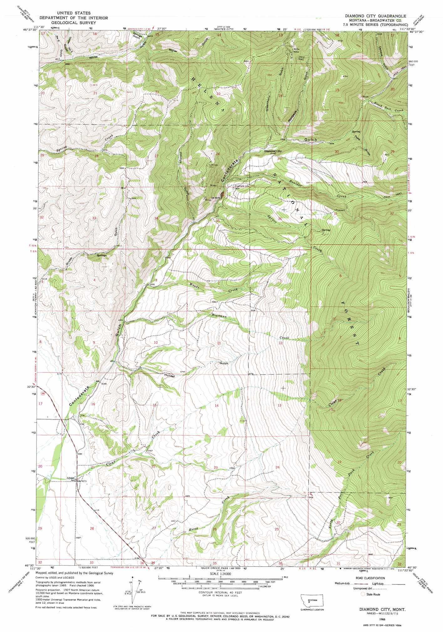
USGS Topo Quad 46111e4 - 1:24,000 scale
| Topo Map Name: | Diamond City |
| USGS Topo Quad ID: | 46111e4 |
| Print Size: | ca. 21 1/4" wide x 27" high |
| Southeast Coordinates: | 46.5° N latitude / 111.375° W longitude |
| Map Center Coordinates: | 46.5625° N latitude / 111.4375° W longitude |
| U.S. State: | MT |
| Filename: | o46111e4.jpg |
| Download Map JPG Image: | Diamond City topo map 1:24,000 scale |
| Map Type: | Topographic |
| Topo Series: | 7.5´ |
| Map Scale: | 1:24,000 |
| Source of Map Images: | United States Geological Survey (USGS) |
| Alternate Map Versions: |
Diamond City MT 1966, updated 1970 Download PDF Buy paper map Diamond City MT 1966, updated 1970 Download PDF Buy paper map Diamond City MT 2001, updated 2004 Download PDF Buy paper map Diamond City MT 2011 Download PDF Buy paper map Diamond City MT 2014 Download PDF Buy paper map |
| FStopo: | US Forest Service topo Diamond City is available: Download FStopo PDF Download FStopo TIF |
1:24,000 Topo Quads surrounding Diamond City
Hogback Mountain |
Snedaker Basin |
Lingshire |
Ellis Canyon |
Devils Footstool |
Canyon Ferry |
Hellgate Gulch |
Whites City |
Watson |
Fort Logan |
Canyon Ferry Sw |
Canyon Ferry Se |
Diamond City |
Boulder Baldy |
Gipsy Lake |
Winston |
Townsend Ne |
Gurnett Creek West |
Gurnett Creek East |
Mount Edith |
Giant Hill |
Townsend |
Holker |
Lippert Gulch |
Sulphur Bar Creek |
> Back to 46111e1 at 1:100,000 scale
> Back to 46110a1 at 1:250,000 scale
> Back to U.S. Topo Maps home
Diamond City topo map: Gazetteer
Diamond City: Mines
Baker Mine elevation 1489m 4885′Boom Mine elevation 1751m 5744′
Miller Mine elevation 1946m 6384′
Miller Mine elevation 1902m 6240′
Montana Regent Mine elevation 1575m 5167′
NE NW Section 25 Mine elevation 1598m 5242′
NE SW Section 26 Mine elevation 1821m 5974′
Silver Snowflake Mine elevation 1582m 5190′
Upper Number 2 Gulch Mine elevation 1523m 4996′
Diamond City: Populated Places
Barker elevation 1259m 4130′Diamond City elevation 1482m 4862′
Noble elevation 1244m 4081′
Diamond City: Post Offices
Diamond City Post Office (historical) elevation 1482m 4862′Johnson Post Office (historical) elevation 1244m 4081′
Diamond City: Streams
Blacktail Creek elevation 1574m 5164′Boulder Creek elevation 1468m 4816′
Clear Creek elevation 1224m 4015′
Hinaman Creek elevation 1321m 4333′
North Fork Duck Creek elevation 1473m 4832′
North Fork Duck Creek elevation 1575m 5167′
Springs Gulch Creek elevation 1464m 4803′
Spruce Creek elevation 1437m 4714′
Woods Creek elevation 1342m 4402′
Diamond City: Valleys
Cement Gulch elevation 1591m 5219′Greenhorn Gulch elevation 1505m 4937′
Hunter Gulch elevation 1301m 4268′
Jimmys Gulch elevation 1405m 4609′
Lucky Gulch elevation 1612m 5288′
Miller Gulch elevation 1476m 4842′
Montana Gulch elevation 1516m 4973′
Number Two Gulch elevation 1402m 4599′
Pyatt Gulch elevation 1547m 5075′
Springs Gulch elevation 1463m 4799′
Upper Number Two Gulch elevation 1412m 4632′
Diamond City: Wells
09N02E16CCCD01 Well elevation 1247m 4091′09N02E16CDAD01 Well elevation 1290m 4232′
Diamond City digital topo map on disk
Buy this Diamond City topo map showing relief, roads, GPS coordinates and other geographical features, as a high-resolution digital map file on DVD: