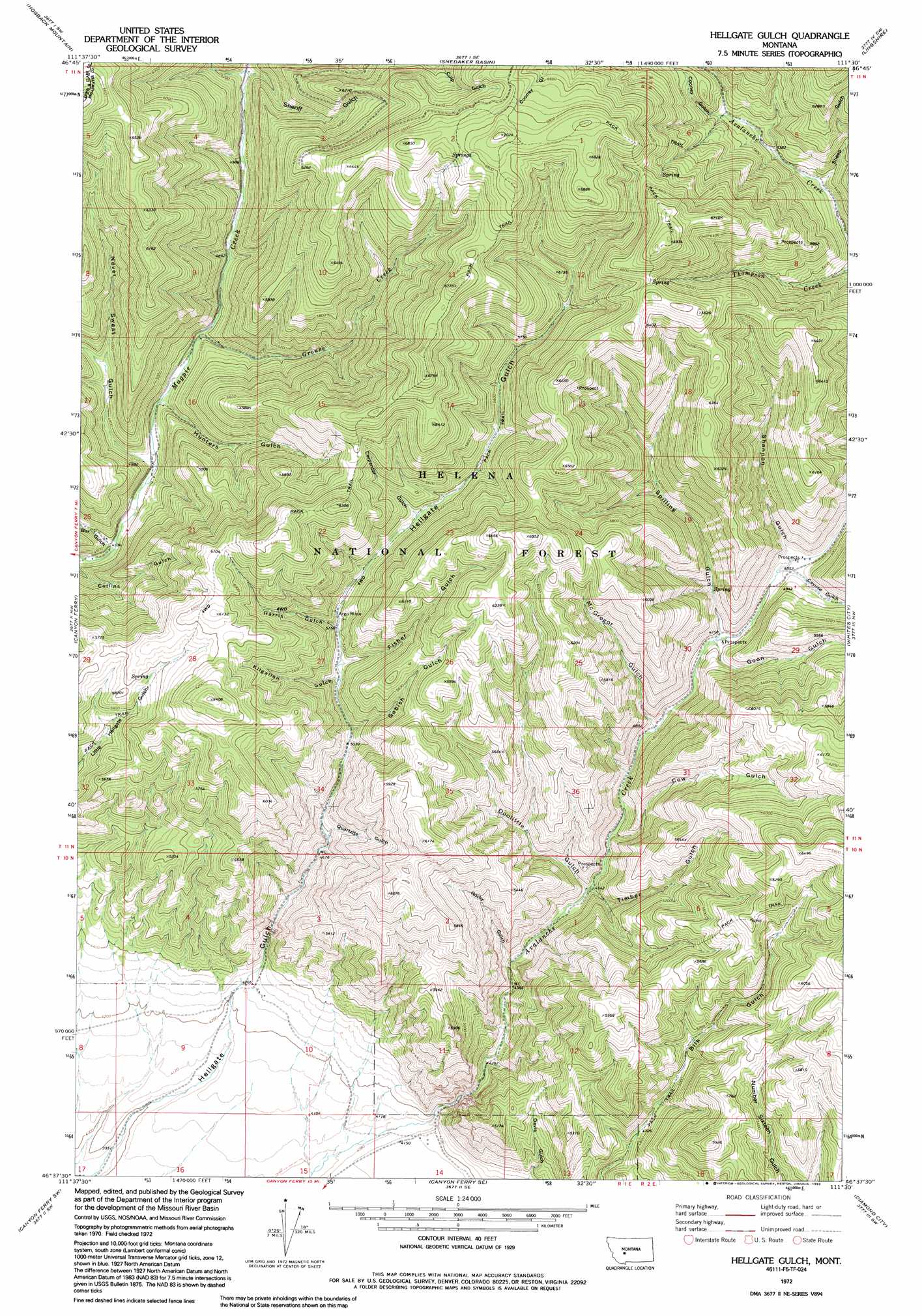
Hellgate Gulch Topo Map Montana
To zoom in, hover over the map of Hellgate Gulch
USGS Topo Quad 46111f5 - 1:24,000 scale
| Topo Map Name: | Hellgate Gulch |
| USGS Topo Quad ID: | 46111f5 |
| Print Size: | ca. 21 1/4" wide x 27" high |
| Southeast Coordinates: | 46.625° N latitude / 111.5° W longitude |
| Map Center Coordinates: | 46.6875° N latitude / 111.5625° W longitude |
| U.S. State: | MT |
| Filename: | o46111f5.jpg |
| Download Map JPG Image: | Hellgate Gulch topo map 1:24,000 scale |
| Map Type: | Topographic |
| Topo Series: | 7.5´ |
| Map Scale: | 1:24,000 |
| Source of Map Images: | United States Geological Survey (USGS) |
| Alternate Map Versions: |
Hellgate Gulch MT 1972, updated 1976 Download PDF Buy paper map Hellgate Gulch MT 1972, updated 1992 Download PDF Buy paper map Hellgate Gulch MT 2001, updated 2004 Download PDF Buy paper map Hellgate Gulch MT 2011 Download PDF Buy paper map Hellgate Gulch MT 2014 Download PDF Buy paper map |
| FStopo: | US Forest Service topo Hellgate Gulch is available: Download FStopo PDF Download FStopo TIF |
1:24,000 Topo Quads surrounding Hellgate Gulch
Candle Mountain |
Middle Creek Lake |
B K Ranch |
Lingshire Nw |
Lingshire Ne |
Nelson |
Hogback Mountain |
Snedaker Basin |
Lingshire |
Ellis Canyon |
Hauser Lake |
Canyon Ferry |
Hellgate Gulch |
Whites City |
Watson |
Louisville |
Canyon Ferry Sw |
Canyon Ferry Se |
Diamond City |
Boulder Baldy |
Casey Peak |
Winston |
Townsend Ne |
Gurnett Creek West |
Gurnett Creek East |
> Back to 46111e1 at 1:100,000 scale
> Back to 46110a1 at 1:250,000 scale
> Back to U.S. Topo Maps home
Hellgate Gulch topo map: Gazetteer
Hellgate Gulch: Mines
Argo Mine elevation 1577m 5173′Doolittle Gulch Mine elevation 1434m 4704′
Thompson Creek Mine elevation 1579m 5180′
Hellgate Gulch: Post Offices
Argo Post Office (historical) elevation 1655m 5429′Hellgate Gulch: Streams
Cayuse Creek elevation 1469m 4819′Grouse Creek elevation 1453m 4767′
Hellgate Gulch: Valleys
Bar Gulch elevation 1387m 4550′Carpenter Gulch elevation 1616m 5301′
Cayuse Gulch elevation 1478m 4849′
Cooney Gulch elevation 1682m 5518′
Cow Gulch elevation 1410m 4625′
Davis Gulch elevation 1360m 4461′
Doolittle Gulch elevation 1391m 4563′
Fisher Gulch elevation 1568m 5144′
Gabish Gulch elevation 1541m 5055′
Goon Gulch elevation 1455m 4773′
Harris Gulch elevation 1577m 5173′
Hunters Gulch elevation 1428m 4685′
Kilgallon Gulch elevation 1560m 5118′
Mc Gregor Gulch elevation 1440m 4724′
Never Sweat Gulch elevation 1404m 4606′
Quartz Gulch elevation 1497m 4911′
Rocky Gulch elevation 1347m 4419′
Shannon Gulch elevation 1478m 4849′
Sheep Gulch elevation 1631m 5351′
Sheriff Gulch elevation 1552m 5091′
Spilling Gulch elevation 1455m 4773′
Timber Gulch elevation 1396m 4580′
Hellgate Gulch: Wells
10N01E14BACA01 Well elevation 1271m 4169′Hellgate Gulch digital topo map on disk
Buy this Hellgate Gulch topo map showing relief, roads, GPS coordinates and other geographical features, as a high-resolution digital map file on DVD: