Bald Hills Topo Map Montana
To zoom in, hover over the map of Bald Hills
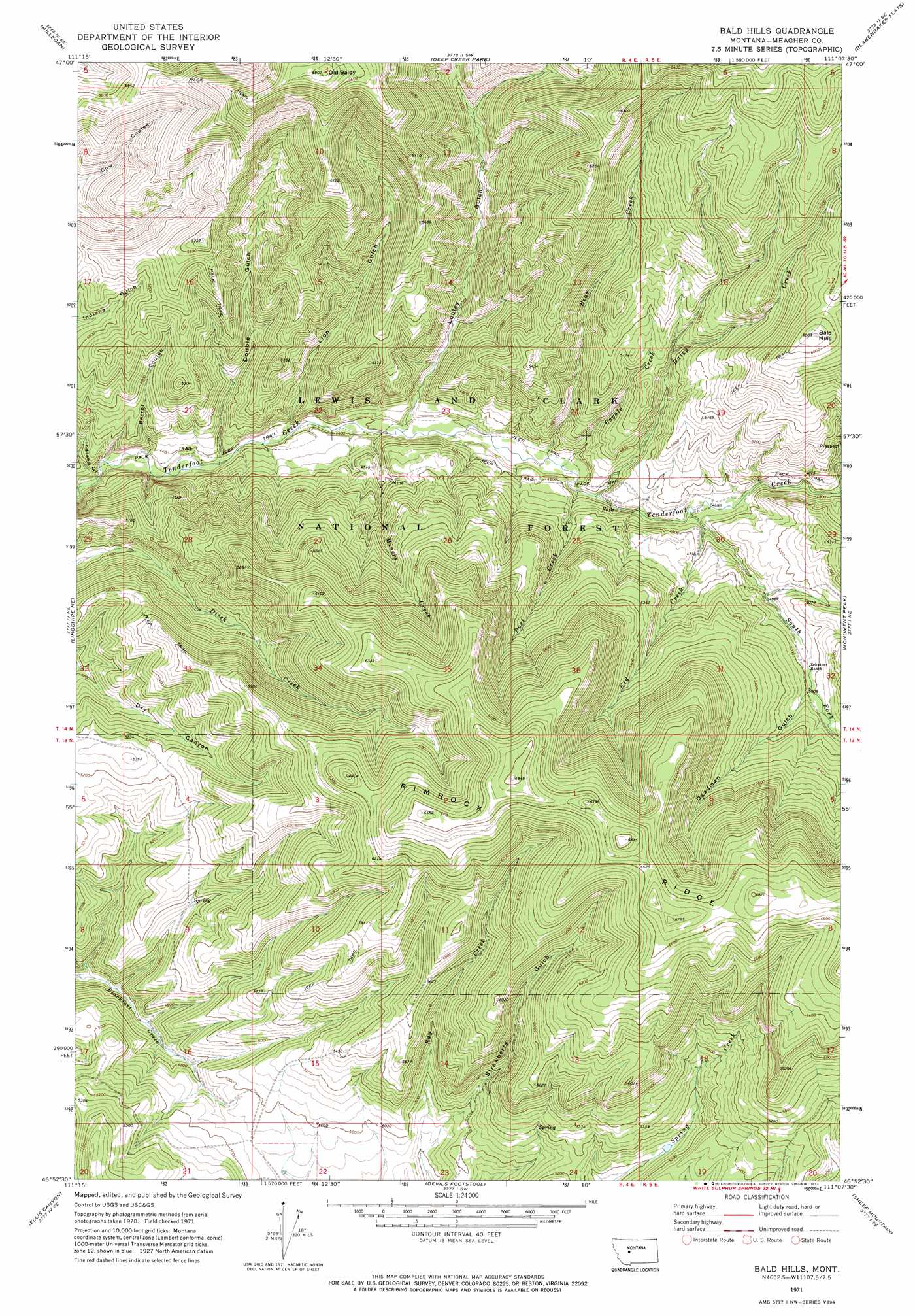
USGS Topo Quad 46111h2 - 1:24,000 scale
| Topo Map Name: | Bald Hills |
| USGS Topo Quad ID: | 46111h2 |
| Print Size: | ca. 21 1/4" wide x 27" high |
| Southeast Coordinates: | 46.875° N latitude / 111.125° W longitude |
| Map Center Coordinates: | 46.9375° N latitude / 111.1875° W longitude |
| U.S. State: | MT |
| Filename: | o46111h2.jpg |
| Download Map JPG Image: | Bald Hills topo map 1:24,000 scale |
| Map Type: | Topographic |
| Topo Series: | 7.5´ |
| Map Scale: | 1:24,000 |
| Source of Map Images: | United States Geological Survey (USGS) |
| Alternate Map Versions: |
Bald Hills MT 1971, updated 1974 Download PDF Buy paper map Bald Hills MT 1995, updated 1997 Download PDF Buy paper map Bald Hills MT 2011 Download PDF Buy paper map Bald Hills MT 2014 Download PDF Buy paper map |
| FStopo: | US Forest Service topo Bald Hills is available: Download FStopo PDF Download FStopo TIF |
1:24,000 Topo Quads surrounding Bald Hills
Spanish Coulee School |
Boston Coulee School |
Calvert |
Evans |
Riceville |
Conway Ridge |
Millegan |
Deep Creek Park |
Blankenbaker Flats |
Thunder Mountain |
Lingshire Nw |
Lingshire Ne |
Bald Hills |
Monument Peak |
Bubbling Springs |
Lingshire |
Ellis Canyon |
Devils Footstool |
Sheep Mountain |
Strawberry Butte |
Whites City |
Watson |
Fort Logan |
Whitetail Reservoir |
Coxcombe Butte |
> Back to 46111e1 at 1:100,000 scale
> Back to 46110a1 at 1:250,000 scale
> Back to U.S. Topo Maps home
Bald Hills topo map: Gazetteer
Bald Hills: Mines
Ducolon-Potter Mine elevation 1439m 4721′NW NW Section 26 Mine elevation 1418m 4652′
Bald Hills: Ridges
Rimrock Ridge elevation 2041m 6696′Bald Hills: Springs
Daisy Spring elevation 1877m 6158′Bald Hills: Streams
Bear Creek elevation 1368m 4488′Coyote Creek elevation 1370m 4494′
Daisy Creek elevation 1386m 4547′
Miners Creek elevation 1342m 4402′
Mongar Creek elevation 1435m 4708′
Post Creek elevation 1378m 4520′
South Fork Tenderfoot Creek elevation 1422m 4665′
Bald Hills: Summits
Bald Hills elevation 1855m 6085′Old Baldy elevation 2072m 6797′
Bald Hills: Valleys
Barrel Coulee elevation 1312m 4304′Deadman Gulch elevation 1523m 4996′
Double Gulch elevation 1322m 4337′
Lion Gulch elevation 1337m 4386′
Lobley Gulch elevation 1350m 4429′
Strawberry Gulch elevation 1462m 4796′
Bald Hills digital topo map on disk
Buy this Bald Hills topo map showing relief, roads, GPS coordinates and other geographical features, as a high-resolution digital map file on DVD: