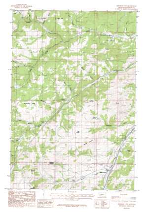
Jefferson City Topo Map Montana
To zoom in, hover over the map of Jefferson City
USGS Topo Quad 46112d1 - 1:24,000 scale
| Topo Map Name: | Jefferson City |
| USGS Topo Quad ID: | 46112d1 |
| Print Size: | ca. 21 1/4" wide x 27" high |
| Southeast Coordinates: | 46.375° N latitude / 112° W longitude |
| Map Center Coordinates: | 46.4375° N latitude / 112.0625° W longitude |
| U.S. State: | MT |
| Filename: | o46112d1.jpg |
| Download Map JPG Image: | Jefferson City topo map 1:24,000 scale |
| Map Type: | Topographic |
| Topo Series: | 7.5´ |
| Map Scale: | 1:24,000 |
| Source of Map Images: | United States Geological Survey (USGS) |
| Alternate Map Versions: |
Jefferson City MT 1985, updated 1986 Download PDF Buy paper map Jefferson City MT 2001, updated 2004 Download PDF Buy paper map Jefferson City MT 2011 Download PDF Buy paper map Jefferson City MT 2014 Download PDF Buy paper map |
| FStopo: | US Forest Service topo Jefferson City is available: Download FStopo PDF Download FStopo TIF |
1:24,000 Topo Quads surrounding Jefferson City
> Back to 46112a1 at 1:100,000 scale
> Back to 46112a1 at 1:250,000 scale
> Back to U.S. Topo Maps home
Jefferson City topo map: Gazetteer
Jefferson City: Crossings
Interchange 176 elevation 1391m 4563′Jefferson City: Flats
McCauley Flats elevation 1653m 5423′Jefferson City: Mines
Bertha Mine elevation 1595m 5232′Black Jack Mine elevation 1634m 5360′
Free Coinage Mine elevation 1340m 4396′
Gregory Mine elevation 1696m 5564′
Gregory Mine elevation 1676m 5498′
Little Nellie Mine elevation 1394m 4573′
Minnesota Mine elevation 1695m 5561′
O K Mine elevation 1421m 4662′
Rarus Mine elevation 1766m 5793′
Roosevelt Mine elevation 1395m 4576′
SE SE Section 6 Mine elevation 1544m 5065′
Superior/Jubilee Mine elevation 1446m 4744′
SW SE Section 32 Mine elevation 1359m 4458′
Jefferson City: Parks
Freighters Historical Marker elevation 1366m 4481′Jefferson City: Populated Places
Corbin elevation 1453m 4767′Jefferson City elevation 1391m 4563′
Jefferson City: Post Offices
Alta Post Office (historical) elevation 1490m 4888′Corbin Post Office (historical) elevation 1453m 4767′
Gregory Post Office (historical) elevation 1698m 5570′
Jefferson City Post Office elevation 1391m 4563′
Jefferson City: Springs
Mudd Springs elevation 1611m 5285′Wheel Springs elevation 1538m 5045′
Jefferson City: Streams
Beavertown Creek elevation 1406m 4612′Buffalo Creek elevation 1419m 4655′
Go Devil Creek elevation 1512m 4960′
North Fork Travis Creek elevation 1560m 5118′
Quartz Creek elevation 1538m 5045′
Spring Creek elevation 1390m 4560′
Travis Creek elevation 1539m 5049′
Jefferson City: Summits
Blueball Mountain elevation 1740m 5708′Emerson Peak elevation 1598m 5242′
Gregory Mountain elevation 1878m 6161′
Valparaiso Mountain elevation 1899m 6230′
Windy Butte elevation 1672m 5485′
Wolf Mountain elevation 1774m 5820′
Jefferson City: Valleys
Browns Gulch elevation 1366m 4481′Corral Gulch elevation 1560m 5118′
Kelly Gulch elevation 1402m 4599′
Little Buffalo Gulch elevation 1360m 4461′
Little Corral Gulch elevation 1646m 5400′
McCauley Gulch elevation 1415m 4642′
Morgan Gulch elevation 1644m 5393′
Ohio Gulch elevation 1300m 4265′
Roe Gulch elevation 1481m 4858′
Westover Gulch elevation 1350m 4429′
Whiteman Gulch elevation 1483m 4865′
Jefferson City: Wells
10N04W11DCAB01 Well elevation 1705m 5593′Jefferson City digital topo map on disk
Buy this Jefferson City topo map showing relief, roads, GPS coordinates and other geographical features, as a high-resolution digital map file on DVD:


