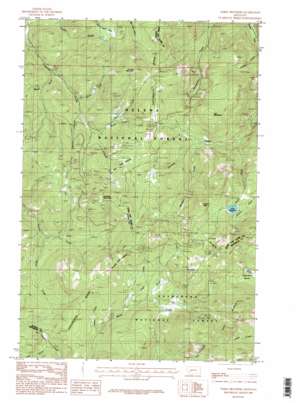
Three Brothers Topo Map Montana
To zoom in, hover over the map of Three Brothers
USGS Topo Quad 46112d3 - 1:24,000 scale
| Topo Map Name: | Three Brothers |
| USGS Topo Quad ID: | 46112d3 |
| Print Size: | ca. 21 1/4" wide x 27" high |
| Southeast Coordinates: | 46.375° N latitude / 112.25° W longitude |
| Map Center Coordinates: | 46.4375° N latitude / 112.3125° W longitude |
| U.S. State: | MT |
| Filename: | o46112d3.jpg |
| Download Map JPG Image: | Three Brothers topo map 1:24,000 scale |
| Map Type: | Topographic |
| Topo Series: | 7.5´ |
| Map Scale: | 1:24,000 |
| Source of Map Images: | United States Geological Survey (USGS) |
| Alternate Map Versions: |
Three Brothers MT 1985, updated 1986 Download PDF Buy paper map Three Brothers MT 1985, updated 1986 Download PDF Buy paper map Three Brothers MT 2001, updated 2004 Download PDF Buy paper map Three Brothers MT 2011 Download PDF Buy paper map Three Brothers MT 2014 Download PDF Buy paper map |
| FStopo: | US Forest Service topo Three Brothers is available: Download FStopo PDF Download FStopo TIF |
1:24,000 Topo Quads surrounding Three Brothers
> Back to 46112a1 at 1:100,000 scale
> Back to 46112a1 at 1:250,000 scale
> Back to U.S. Topo Maps home
Three Brothers topo map: Gazetteer
Three Brothers: Dams
Scott Reservoir Dam elevation 2354m 7723′Three Brothers: Flats
Bullion Parks elevation 2128m 6981′Cataract Meadows elevation 2205m 7234′
Three Brothers: Mines
19 Hundred elevation 2159m 7083′Anna R/Hattie M Mine elevation 2044m 6706′
Armstrong Mine elevation 1805m 5921′
Beatrice elevation 2071m 6794′
Beattrice Mine elevation 2107m 6912′
Blue Boy elevation 2102m 6896′
Buckeye Mine elevation 2174m 7132′
Buckeye Mine elevation 2168m 7112′
Bullion Mine elevation 2123m 6965′
Champion Mine elevation 2086m 6843′
Close Shave elevation 2047m 6715′
Daniel Stanton elevation 1747m 5731′
Dan-Kim elevation 2188m 7178′
Dorothy Snow Mine elevation 2251m 7385′
Excelsior Mine elevation 2108m 6916′
Hard Luck Mine elevation 1993m 6538′
Hard Luck Mine elevation 1948m 6391′
Home Stake Mine elevation 2164m 7099′
Hub Camp Mine elevation 1786m 5859′
Jimmy elevation 1900m 6233′
Josephine Mine elevation 2222m 7290′
Justice Mine elevation 1896m 6220′
Lady Hennessy Mine elevation 2339m 7673′
Lady Nell/Ada Mine elevation 2436m 7992′
Lily/Orphan Boy Mine elevation 2095m 6873′
Lily-Orphan Boy Mine elevation 2075m 6807′
Lucky Joe elevation 1976m 6482′
May Day elevation 2216m 7270′
May Lillie Mine elevation 2497m 8192′
May-Lillie Mine elevation 2495m 8185′
Molly Snow Mine elevation 2210m 7250′
Monte Cristo Mine elevation 1916m 6286′
Monte Cristo Mine elevation 1980m 6496′
NE NW Section 23 elevation 2229m 7312′
NE NW Section 6 Mine elevation 2312m 7585′
NW NE Section 27 Mine elevation 2161m 7089′
NW NW Section 13 elevation 2160m 7086′
NW SW Section 15 Mine elevation 2123m 6965′
Ontario Millsite elevation 2146m 7040′
Ontario Mine elevation 2142m 7027′
Paupers Dream Mine elevation 2336m 7664′
Perry Parks Mine elevation 2146m 7040′
Perry Parks Placer Mine elevation 2146m 7040′
Peter elevation 2260m 7414′
Placer elevation 1873m 6145′
Placer Mine elevation 2223m 7293′
Pocahontas elevation 1809m 5935′
Porphyry Dike Mine elevation 2271m 7450′
Rocker/Ada Mine elevation 2328m 7637′
SE NW Section 30 Mine elevation 2347m 7700′
SE SE Section 13 elevation 2070m 6791′
SE SE Section 15 Mine elevation 2243m 7358′
SE SE Section 35 Mine elevation 2132m 6994′
Solar Mine elevation 2142m 7027′
Solar Mine elevation 2152m 7060′
Sure Thing Mine elevation 2200m 7217′
Sure Thing Mine elevation 2198m 7211′
SW NW Section 26 Mine elevation 2210m 7250′
SW NW Section 7 Mine elevation 2225m 7299′
SW SE Section 10 Mine elevation 2029m 6656′
SW SE Section 5 elevation 1737m 5698′
Telegraph Mine elevation 2053m 6735′
West Ontario Mine elevation 2144m 7034′
Woodrow Wilson elevation 2334m 7657′
Three Brothers: Post Offices
Ontario Post Office (historical) elevation 2155m 7070′Three Brothers: Reservoirs
Scott Reservoir elevation 2185m 7168′Travis Reservoir elevation 2059m 6755′
Three Brothers: Streams
Banner Creek elevation 1757m 5764′Bison Creek elevation 1939m 6361′
Bryan Creek elevation 1936m 6351′
Clear Creek elevation 2123m 6965′
Jericho Creek elevation 1840m 6036′
Jimmys Creek elevation 2094m 6870′
Monitor Creek elevation 1908m 6259′
O'Keefe Creek elevation 1898m 6227′
Ruby Creek elevation 1843m 6046′
Sally Ann Creek elevation 1926m 6318′
Spring Creek elevation 1690m 5544′
Three Brothers: Summits
Jericho Mountain elevation 2231m 7319′Lee Mountain elevation 2148m 7047′
Luttrell Peak elevation 2354m 7723′
O'Keefe Mountain elevation 2296m 7532′
Old Baldy Mountain elevation 2498m 8195′
Three Brothers elevation 2604m 8543′
Three Brothers: Swamps
Sure Thing Swamps elevation 2102m 6896′Three Brothers: Valleys
Booth Gulch elevation 1770m 5807′Clemmer Gulch elevation 1890m 6200′
Elk Gulch elevation 2081m 6827′
Flume Gulch elevation 1693m 5554′
Grub Gulch elevation 2135m 7004′
Moose Gulch elevation 1685m 5528′
Three Brothers digital topo map on disk
Buy this Three Brothers topo map showing relief, roads, GPS coordinates and other geographical features, as a high-resolution digital map file on DVD:


