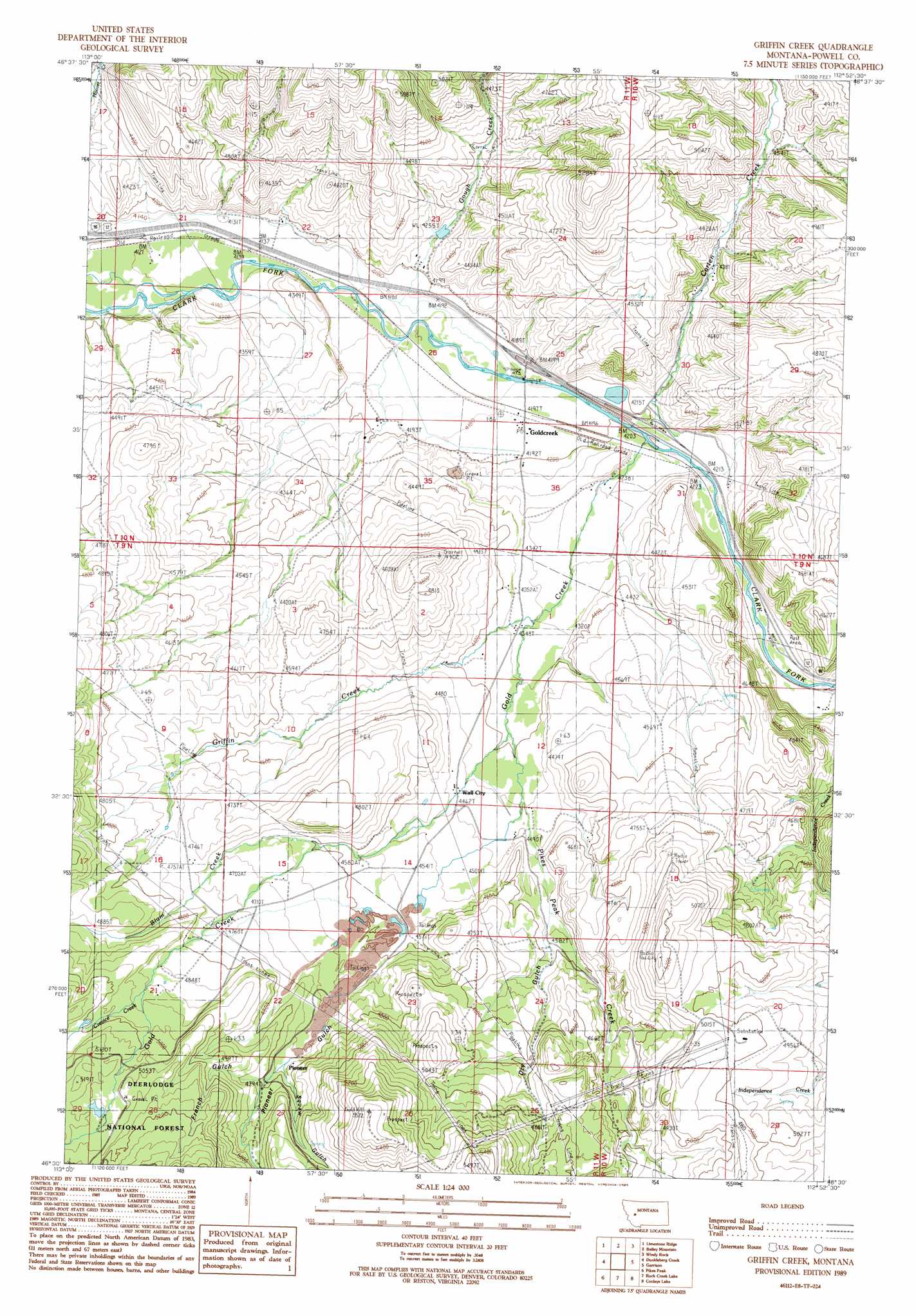
Griffin Creek Topo Map Montana
To zoom in, hover over the map of Griffin Creek
USGS Topo Quad 46112e8 - 1:24,000 scale
| Topo Map Name: | Griffin Creek |
| USGS Topo Quad ID: | 46112e8 |
| Print Size: | ca. 21 1/4" wide x 27" high |
| Southeast Coordinates: | 46.5° N latitude / 112.875° W longitude |
| Map Center Coordinates: | 46.5625° N latitude / 112.9375° W longitude |
| U.S. State: | MT |
| Filename: | o46112e8.jpg |
| Download Map JPG Image: | Griffin Creek topo map 1:24,000 scale |
| Map Type: | Topographic |
| Topo Series: | 7.5´ |
| Map Scale: | 1:24,000 |
| Source of Map Images: | United States Geological Survey (USGS) |
| Alternate Map Versions: |
Griffin Creek MT 1989, updated 1989 Download PDF Buy paper map Griffin Creek MT 1996, updated 1998 Download PDF Buy paper map Griffin Creek MT 2011 Download PDF Buy paper map Griffin Creek MT 2014 Download PDF Buy paper map |
| FStopo: | US Forest Service topo Griffin Creek is available: Download FStopo PDF Download FStopo TIF |
1:24,000 Topo Quads surrounding Griffin Creek
Wild Horse Parks |
Chimney Lakes |
Helmville |
Nevada Lake |
Finn |
Drummond |
Limestone Ridge |
Bailey Mountain |
Windy Rock |
Gravely Mountain |
Hall |
Dunkleberg Creek |
Griffin Creek |
Garrison |
Luke Mountain |
Maxville |
Pikes Peak |
Rock Creek Lake |
Conleys Lake |
Deer Lodge |
Fred Burr Lake |
Pozega Lakes |
Mount Powell |
Racetrack |
Orofino Creek |
> Back to 46112e1 at 1:100,000 scale
> Back to 46112a1 at 1:250,000 scale
> Back to U.S. Topo Maps home
Griffin Creek topo map: Gazetteer
Griffin Creek: Crossings
Interchange 166 elevation 1281m 4202′Griffin Creek: Dams
Anderson Dam elevation 1445m 4740′Griffin Creek: Mines
Grant Mine elevation 1455m 4773′Placer Mine elevation 1359m 4458′
Placer Mines elevation 1456m 4776′
Griffin Creek: Populated Places
Dutton elevation 1286m 4219′Goldcreek elevation 1277m 4189′
Lingenpolter elevation 1423m 4668′
Pioneer elevation 1450m 4757′
Wall City elevation 1363m 4471′
Griffin Creek: Post Offices
Goldcreek Post Office elevation 1277m 4189′Pikes Peak Post Office (historical) elevation 1463m 4799′
Pioneer Post Office (historical) elevation 1450m 4757′
Griffin Creek: Springs
10N11W22BDCD01 Spring elevation 1281m 4202′Griffin Creek: Streams
Blum Creek elevation 1404m 4606′Carten Creek elevation 1276m 4186′
Crevice Creek elevation 1483m 4865′
Gold Creek elevation 1282m 4206′
Gough Creek elevation 1269m 4163′
Griffin Creek elevation 1318m 4324′
Pikes Peak Creek elevation 1339m 4393′
Griffin Creek: Valleys
Dry Gulch elevation 1388m 4553′French Gulch elevation 1461m 4793′
Pioneer Gulch elevation 1403m 4603′
Sin-pul-stu-weh Gulch elevation 1449m 4753′
Griffin Creek: Wells
09N10W05CBA_01 Well elevation 1294m 4245′09N10W08ABDB01 Well elevation 1293m 4242′
09N10W08ABDB02 Well elevation 1292m 4238′
09N10W08ABDB03 Well elevation 1293m 4242′
09N11W01BCAC01 Well elevation 1329m 4360′
09N11W01CABB01 Well elevation 1323m 4340′
09N11W11DCDA01 Well elevation 1365m 4478′
09N11W13BAAC01 Well elevation 1356m 4448′
09N11W15DAAC01 Well elevation 1422m 4665′
09N11W16ADCC01 Well elevation 1449m 4753′
09N11W16DDCD01 Well elevation 1457m 4780′
09N11W21ACCC01 Well elevation 1485m 4872′
10N10W19DCCC01 Well elevation 1335m 4379′
10N10W30CCD_01 Well elevation 1280m 4199′
10N10W31ADCA01 Well elevation 1293m 4242′
10N10W31BABA02 Well elevation 1287m 4222′
10N11W20DAAD01 Well elevation 1262m 4140′
10N11W21CDBC01 Well elevation 1258m 4127′
10N11W22BCDD01 Well elevation 1278m 4192′
10N11W23CADC01 Well elevation 1288m 4225′
10N11W25CBAC01 Well elevation 1274m 4179′
10N11W25CCDD01 Well elevation 1277m 4189′
10N11W35BBBC01 Well elevation 1283m 4209′
10N11W36ACDD01 Well elevation 1305m 4281′
10N11W36BABB01 Well elevation 1279m 4196′
10N11W36BBAA01 Well elevation 1278m 4192′
10N11W36BCAD01 Well elevation 1288m 4225′
Griffin Creek digital topo map on disk
Buy this Griffin Creek topo map showing relief, roads, GPS coordinates and other geographical features, as a high-resolution digital map file on DVD: