Austin Topo Map Montana
To zoom in, hover over the map of Austin
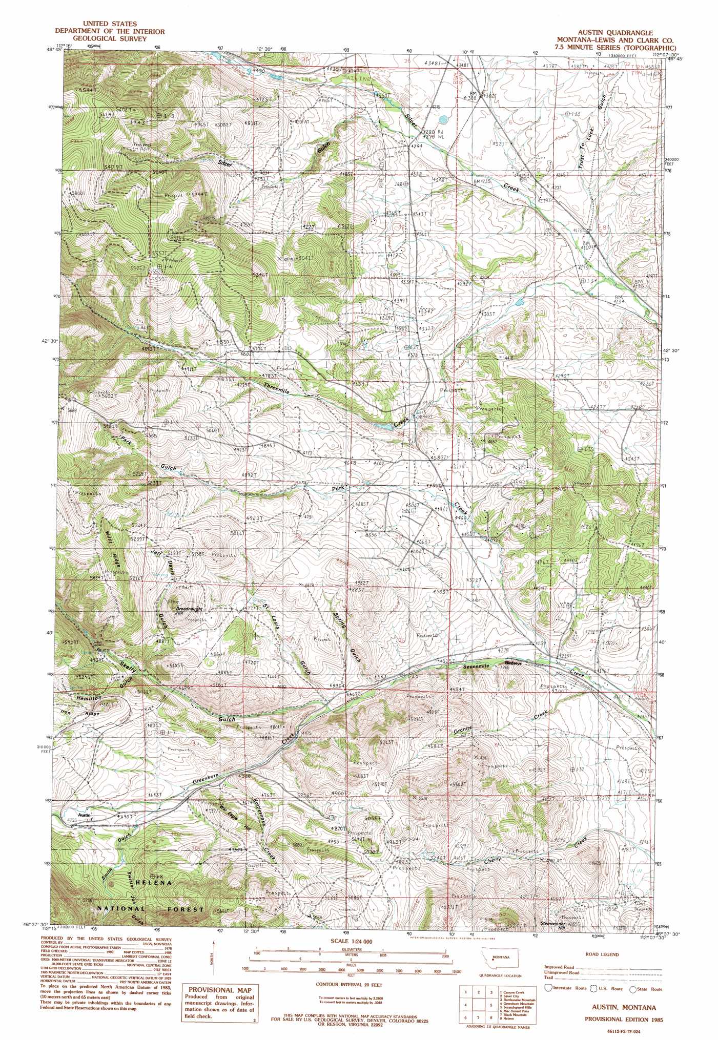
USGS Topo Quad 46112f2 - 1:24,000 scale
| Topo Map Name: | Austin |
| USGS Topo Quad ID: | 46112f2 |
| Print Size: | ca. 21 1/4" wide x 27" high |
| Southeast Coordinates: | 46.625° N latitude / 112.125° W longitude |
| Map Center Coordinates: | 46.6875° N latitude / 112.1875° W longitude |
| U.S. State: | MT |
| Filename: | o46112f2.jpg |
| Download Map JPG Image: | Austin topo map 1:24,000 scale |
| Map Type: | Topographic |
| Topo Series: | 7.5´ |
| Map Scale: | 1:24,000 |
| Source of Map Images: | United States Geological Survey (USGS) |
| Alternate Map Versions: |
Austin MT 1985, updated 1985 Download PDF Buy paper map Austin MT 2001, updated 2004 Download PDF Buy paper map Austin MT 2011 Download PDF Buy paper map Austin MT 2014 Download PDF Buy paper map |
| FStopo: | US Forest Service topo Austin is available: Download FStopo PDF Download FStopo TIF |
1:24,000 Topo Quads surrounding Austin
Stemple Pass |
Wilborn |
Mitchell Mountain |
Sheep Creek |
Beartooth Mountain |
Granite Butte |
Canyon Creek |
Silver City |
Rattlesnake Mountain |
Upper Holter Lake |
Esmeralda Hill |
Greenhorn Mountain |
Austin |
Scratchgravel Hill |
Lake Helena |
Elliston |
Macdonald Pass |
Black Mountain |
Helena |
East Helena |
Bison Mountain |
Three Brothers |
Chessman Reservoir |
Jefferson City |
Clancy |
> Back to 46112e1 at 1:100,000 scale
> Back to 46112a1 at 1:250,000 scale
> Back to U.S. Topo Maps home
Austin topo map: Gazetteer
Austin: Airports
Silver City Airport elevation 1335m 4379′Austin: Dams
Three Mile Reservoir Dam elevation 1364m 4475′Austin: Mines
Betty Anne Mine elevation 1474m 4835′Bulls Head Mine elevation 1535m 5036′
Dreadnaught/Paymaster Mine elevation 1580m 5183′
Granite Creek Mine elevation 1406m 4612′
Green Bird Mine elevation 1369m 4491′
Jeff Davis Gulch Mine elevation 1555m 5101′
King Tut Mine elevation 1463m 4799′
NE NE Section 33 Mine elevation 1677m 5501′
NE SE Section 16 Mine elevation 1521m 4990′
NE SW Section 6 Mine elevation 1424m 4671′
SE NE Section 3 Mine elevation 1434m 4704′
SE NW Section 18 Mine elevation 1575m 5167′
SE SW Section 27 Mine elevation 1569m 5147′
Silver Creek Placer Mine elevation 1420m 4658′
Sitzer Gulch Mine elevation 1575m 5167′
Spring Gulch Mine elevation 1395m 4576′
SW NW Section 6 Mine elevation 1417m 4648′
SW SE Section 18 Mine elevation 1326m 4350′
Austin: Populated Places
Austin elevation 1449m 4753′Birdseye elevation 1295m 4248′
Gearing elevation 1260m 4133′
Austin: Post Offices
Austin Post Office (historical) elevation 1449m 4753′Birdseye Post Office (historical) elevation 1295m 4248′
Greenhorn Post Office (historical) elevation 1449m 4753′
Austin: Ridges
Iron Ridge elevation 1521m 4990′Willit Ridge elevation 1762m 5780′
Austin: Springs
10N04W17BAAD01 Spring elevation 1296m 4251′11N05W13CBAA01 Spring elevation 1325m 4347′
11N05W13CBBD01 Spring elevation 1368m 4488′
Austin: Streams
Granite Creek elevation 1269m 4163′Greenhorn Creek elevation 1345m 4412′
Park Creek elevation 1282m 4206′
Rattlesnake Creek elevation 1392m 4566′
Threemile Creek elevation 1259m 4130′
Austin: Summits
Dreadnaught Hill elevation 1613m 5291′Stemwinder Hill elevation 1396m 4580′
War Eagle Hill elevation 1526m 5006′
Austin: Valleys
Hamilton Gulch elevation 1464m 4803′Jeff Davis Gulch elevation 1458m 4783′
Park Gulch elevation 1488m 4881′
Saint Louis Gulch elevation 1355m 4445′
Sitzer Gulch elevation 1336m 4383′
Skelly Gulch elevation 1359m 4458′
Smith Gulch elevation 1456m 4776′
Spring Gulch elevation 1361m 4465′
Switzer Joe Gulch elevation 1428m 4685′
Trust-to-Luck Gulch elevation 1276m 4186′
Austin: Wells
10N04W05AADB01 Well elevation 1263m 4143′10N05W03ABCB01 Well elevation 1419m 4655′
10N05W10ADBB01 Well elevation 1472m 4829′
11N04W06DCCC01 Well elevation 1292m 4238′
11N04W20BBCD01 Well elevation 1327m 4353′
11N04W20DCBD01 Well elevation 1345m 4412′
11N04W30ACBC01 Well elevation 1387m 4550′
11N04W32ADCB01 Well elevation 1318m 4324′
11N05W14ADAA01 Well elevation 1388m 4553′
11N05W14CABC01 Well elevation 1463m 4799′
11N05W15DBAA01 Well elevation 1500m 4921′
11N05W21AABD01 Well elevation 1650m 5413′
11N05W23CBAA01 Well elevation 1477m 4845′
11N05W25BCCC01 Well elevation 1441m 4727′
11N05W35BCCB01 Well elevation 1447m 4747′
Austin digital topo map on disk
Buy this Austin topo map showing relief, roads, GPS coordinates and other geographical features, as a high-resolution digital map file on DVD: