Corley Gulch Topo Map Montana
To zoom in, hover over the map of Corley Gulch
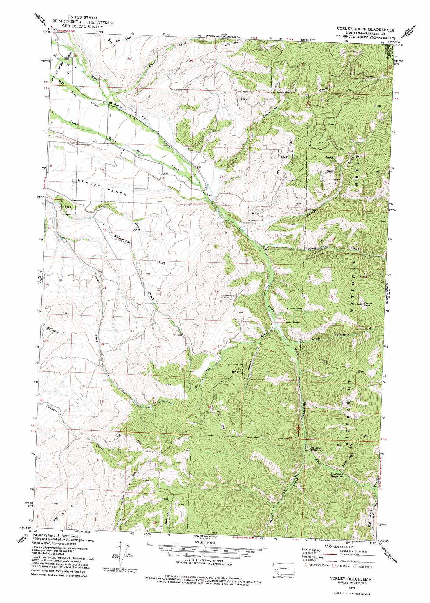
USGS Topo Quad 46113d8 - 1:24,000 scale
| Topo Map Name: | Corley Gulch |
| USGS Topo Quad ID: | 46113d8 |
| Print Size: | ca. 21 1/4" wide x 27" high |
| Southeast Coordinates: | 46.375° N latitude / 113.875° W longitude |
| Map Center Coordinates: | 46.4375° N latitude / 113.9375° W longitude |
| U.S. State: | MT |
| Filename: | o46113d8.jpg |
| Download Map JPG Image: | Corley Gulch topo map 1:24,000 scale |
| Map Type: | Topographic |
| Topo Series: | 7.5´ |
| Map Scale: | 1:24,000 |
| Source of Map Images: | United States Geological Survey (USGS) |
| Alternate Map Versions: |
Corley Gulch MT 1977, updated 1978 Download PDF Buy paper map Corley Gulch MT 1998, updated 2002 Download PDF Buy paper map Corley Gulch MT 2011 Download PDF Buy paper map Corley Gulch MT 2014 Download PDF Buy paper map |
| FStopo: | US Forest Service topo Corley Gulch is available: Download FStopo PDF Download FStopo TIF |
1:24,000 Topo Quads surrounding Corley Gulch
Carlton Lake |
Florence |
Davis Point |
Elk Mountain |
Iris Point |
Saint Mary Peak |
Stevensville |
Grayhorse Creek |
Cleveland Mountain |
Grizzly Point |
Victor |
Bing |
Corley Gulch |
Sawmill Saddle |
Quigg Peak |
Hamilton North |
Corvallis |
Willow Mountain |
Burnt Fork Lake |
Stony Creek |
Hamilton South |
Mountain House |
Gird Point |
Skalkaho Pass |
Mount Emerine |
> Back to 46113a1 at 1:100,000 scale
> Back to 46112a1 at 1:250,000 scale
> Back to U.S. Topo Maps home
Corley Gulch topo map: Gazetteer
Corley Gulch: Mines
NW SW Section 9 Mine elevation 1550m 5085′SE NW Section 7 Mine elevation 1546m 5072′
Corley Gulch: Populated Places
Burnt Fork (historical) elevation 1295m 4248′Corley Gulch: Post Offices
Rosemont Post Office (historical) elevation 1406m 4612′Corley Gulch: Streams
Burnt Fork Bitterroot River elevation 1288m 4225′Claremont Creek elevation 1313m 4307′
Flat Rock Creek elevation 1532m 5026′
Gold Creek elevation 1468m 4816′
Grizzly Creek elevation 1534m 5032′
Haacke Creek elevation 1322m 4337′
Little Threemile Creek elevation 1399m 4589′
North Fork Willoughby Creek elevation 1245m 4084′
Sawmill Creek elevation 1339m 4393′
Slocum Creek elevation 1250m 4101′
Smythe Creek elevation 1444m 4737′
Corley Gulch: Summits
Whe-lha-kleh-tseen Mountain elevation 2030m 6660′Corley Gulch: Valleys
Corley Gulch elevation 1399m 4589′Cutoff Gulch elevation 1511m 4957′
Corley Gulch: Wells
08N19W11CDBB01 Well elevation 1295m 4248′Corley Gulch digital topo map on disk
Buy this Corley Gulch topo map showing relief, roads, GPS coordinates and other geographical features, as a high-resolution digital map file on DVD: