Harvey Point Topo Map Montana
To zoom in, hover over the map of Harvey Point
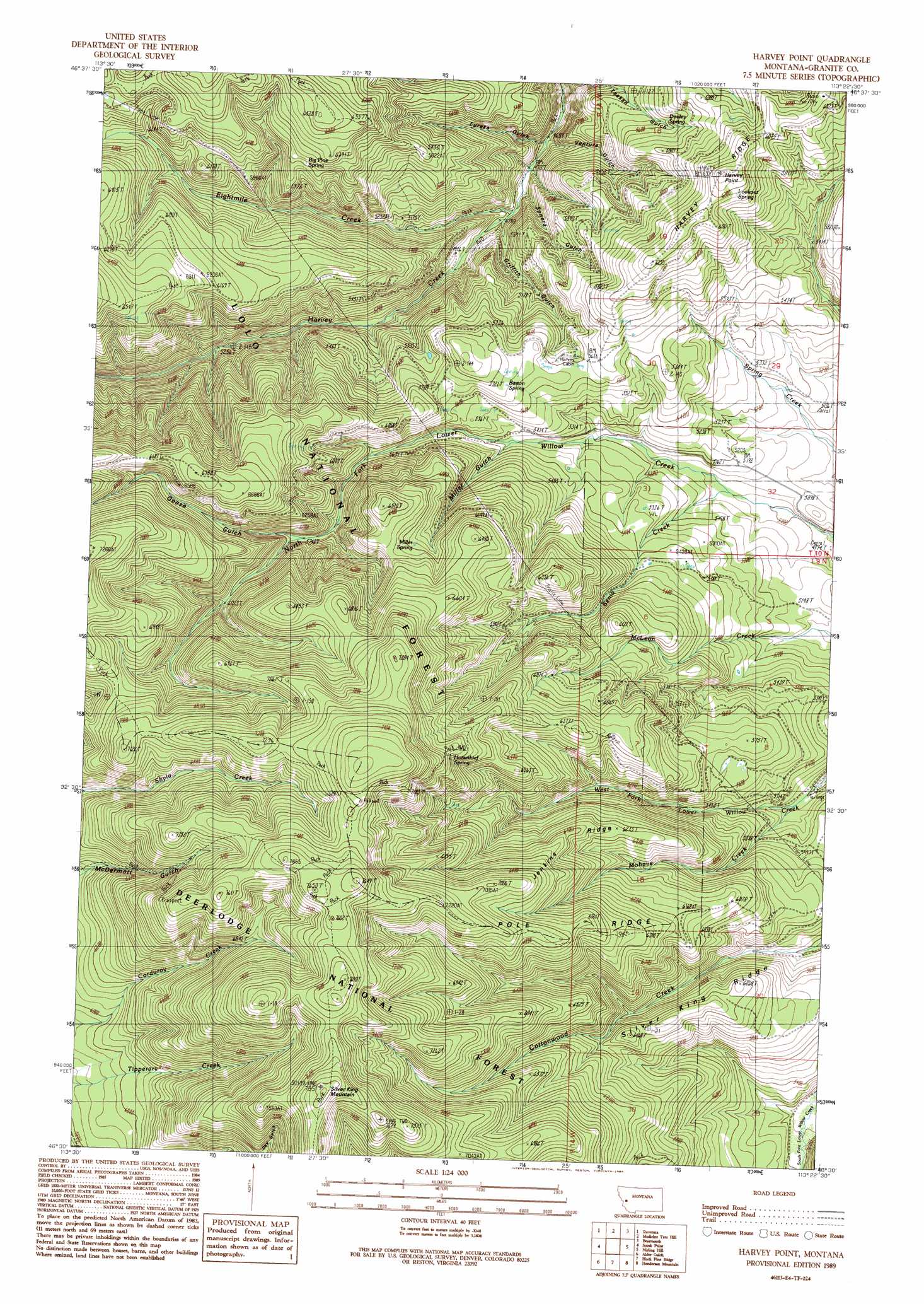
USGS Topo Quad 46113e4 - 1:24,000 scale
| Topo Map Name: | Harvey Point |
| USGS Topo Quad ID: | 46113e4 |
| Print Size: | ca. 21 1/4" wide x 27" high |
| Southeast Coordinates: | 46.5° N latitude / 113.375° W longitude |
| Map Center Coordinates: | 46.5625° N latitude / 113.4375° W longitude |
| U.S. State: | MT |
| Filename: | o46113e4.jpg |
| Download Map JPG Image: | Harvey Point topo map 1:24,000 scale |
| Map Type: | Topographic |
| Topo Series: | 7.5´ |
| Map Scale: | 1:24,000 |
| Source of Map Images: | United States Geological Survey (USGS) |
| Alternate Map Versions: |
Harvey Point MT 1989, updated 1989 Download PDF Buy paper map Harvey Point MT 1996, updated 1998 Download PDF Buy paper map Harvey Point MT 2011 Download PDF Buy paper map Harvey Point MT 2014 Download PDF Buy paper map |
| FStopo: | US Forest Service topo Harvey Point is available: Download FStopo PDF Download FStopo TIF |
1:24,000 Topo Quads surrounding Harvey Point
Clinton |
Mineral Ridge |
Union Peak |
Elevation Mountain |
Wild Horse Parks |
Iris Point |
Ravenna |
Medicine Tree Hill |
Bearmouth |
Drummond |
Grizzly Point |
Spink Point |
Harvey Point |
Nirling Hill |
Hall |
Quigg Peak |
Alder Gulch |
Black Pine Ridge |
Henderson Mountain |
Maxville |
Stony Creek |
Cornish Gulch |
Antelope Creek |
Philipsburg |
Fred Burr Lake |
> Back to 46113e1 at 1:100,000 scale
> Back to 46112a1 at 1:250,000 scale
> Back to U.S. Topo Maps home
Harvey Point topo map: Gazetteer
Harvey Point: Ridges
Harvey Ridge elevation 1791m 5875′Jenkins Ridge elevation 1957m 6420′
Pole Ridge elevation 2061m 6761′
Silver King Ridge elevation 1759m 5770′
Harvey Point: Springs
Barton Spring elevation 1744m 5721′Big Pine Spring elevation 1824m 5984′
Dooley Spring elevation 1704m 5590′
Horsethief Spring elevation 2028m 6653′
Lookout Spring elevation 1889m 6197′
Miller Spring elevation 1878m 6161′
Harvey Point: Streams
Eightmile Creek elevation 1480m 4855′Mohave Creek elevation 1593m 5226′
Senia Creek elevation 1543m 5062′
Harvey Point: Summits
Harvey Point elevation 1918m 6292′Silver King Mountain elevation 2392m 7847′
Harvey Point: Trails
Black Pine Trail elevation 2323m 7621′Eightmile Harvey Ridge Trail elevation 1923m 6309′
Pole Ridge Trail elevation 2167m 7109′
Harvey Point: Valleys
Eureka Gulch elevation 1449m 4753′Goose Gulch elevation 1756m 5761′
Griffith Gulch elevation 1465m 4806′
Miller Gulch elevation 1629m 5344′
Sonora Gulch elevation 1448m 4750′
Ventura Gulch elevation 1436m 4711′
Harvey Point digital topo map on disk
Buy this Harvey Point topo map showing relief, roads, GPS coordinates and other geographical features, as a high-resolution digital map file on DVD: