Elevation Mountain Topo Map Montana
To zoom in, hover over the map of Elevation Mountain
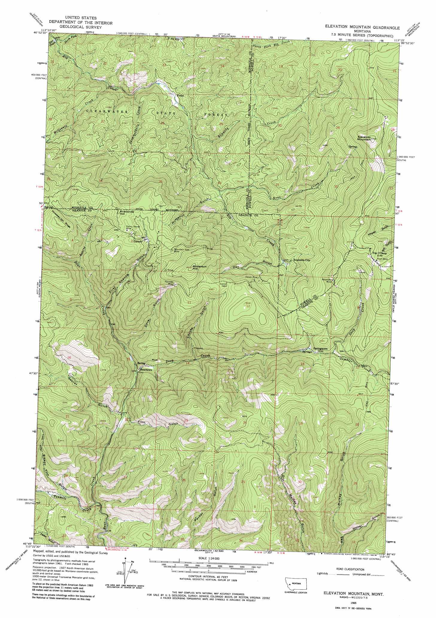
USGS Topo Quad 46113g3 - 1:24,000 scale
| Topo Map Name: | Elevation Mountain |
| USGS Topo Quad ID: | 46113g3 |
| Print Size: | ca. 21 1/4" wide x 27" high |
| Southeast Coordinates: | 46.75° N latitude / 113.25° W longitude |
| Map Center Coordinates: | 46.8125° N latitude / 113.3125° W longitude |
| U.S. State: | MT |
| Filename: | o46113g3.jpg |
| Download Map JPG Image: | Elevation Mountain topo map 1:24,000 scale |
| Map Type: | Topographic |
| Topo Series: | 7.5´ |
| Map Scale: | 1:24,000 |
| Source of Map Images: | United States Geological Survey (USGS) |
| Alternate Map Versions: |
Elevation Mountain MT 1965, updated 1967 Download PDF Buy paper map Elevation Mountain MT 1965, updated 1980 Download PDF Buy paper map Elevation Mountain MT 1965, updated 1980 Download PDF Buy paper map Elevation Mountain MT 2011 Download PDF Buy paper map Elevation Mountain MT 2014 Download PDF Buy paper map |
1:24,000 Topo Quads surrounding Elevation Mountain
Belmont Point |
Salmon Lake |
Woodworth |
Ovando |
Ovando Mountain |
Potomac |
Greenough |
Bata Mountain |
Chamberlain Mountain |
Browns Lake |
Mineral Ridge |
Union Peak |
Elevation Mountain |
Wild Horse Parks |
Chimney Lakes |
Ravenna |
Medicine Tree Hill |
Bearmouth |
Drummond |
Limestone Ridge |
Spink Point |
Harvey Point |
Nirling Hill |
Hall |
Dunkleberg Creek |
> Back to 46113e1 at 1:100,000 scale
> Back to 46112a1 at 1:250,000 scale
> Back to U.S. Topo Maps home
Elevation Mountain topo map: Gazetteer
Elevation Mountain: Mines
Alcona Mine elevation 1990m 6528′Amex Number 1 Mine elevation 1820m 5971′
Amex Number 5 Mine elevation 1855m 6085′
Austin Mine elevation 1814m 5951′
Berlene Mine elevation 1917m 6289′
Boston Mine elevation 2029m 6656′
Cardinal Mine elevation 1948m 6391′
Cascade Mine elevation 1838m 6030′
Cave Hill-Fairview Mine elevation 1852m 6076′
Dandy Mine elevation 1652m 5419′
Dandy Mine elevation 1778m 5833′
Fairview Mine elevation 1924m 6312′
Fourth of July Mine elevation 1813m 5948′
Free Coin - Redcloud Mill Mine elevation 1798m 5898′
Garnet Mine elevation 1850m 6069′
Goldleaf Mine elevation 1938m 6358′
Grant and Hartford Mine elevation 1832m 6010′
Harparanda Mine elevation 1858m 6095′
Herzer and Green Mine elevation 2035m 6676′
Homestake Mine elevation 1843m 6046′
Independence Mine elevation 1848m 6062′
International Mine elevation 1843m 6046′
Lehson Mine elevation 1949m 6394′
Lynx Mine elevation 1848m 6062′
Magone and Anderson Mine elevation 1893m 6210′
Mountain Mine elevation 1973m 6473′
Mountain Mine elevation 1969m 6459′
Mountain View Mine elevation 1882m 6174′
Mountain View Mine elevation 1865m 6118′
Nancy Hanks Mine elevation 1843m 6046′
NW Section 10 Mine elevation 1610m 5282′
Pearl Fraction Mine elevation 2015m 6610′
Pearl Mine elevation 1992m 6535′
Pearl Mine elevation 1994m 6541′
Peggy Ann Mine elevation 1793m 5882′
Red Cloud Mine elevation 1815m 5954′
Redrock Mine elevation 1875m 6151′
Robert Emmet Mine elevation 1874m 6148′
San Jose Mine elevation 1893m 6210′
SE Section 2 Mine elevation 1932m 6338′
Shamrock Mine elevation 1841m 6040′
Sierra Mine elevation 1812m 5944′
Spokane Mine elevation 1757m 5764′
Stone Mine elevation 1908m 6259′
Tiger Mine elevation 1831m 6007′
Tostman Mine elevation 1771m 5810′
Willie Mine elevation 1723m 5652′
Elevation Mountain: Populated Places
Beartown elevation 1399m 4589′Garnet elevation 1800m 5905′
Reynolds City elevation 1673m 5488′
Springtown elevation 1654m 5426′
Stump Town (historical) elevation 1853m 6079′
Top O'Deep elevation 2028m 6653′
Yreka elevation 1396m 4580′
Elevation Mountain: Post Offices
Beartown Post Office (historical) elevation 1399m 4589′Garnet Post Office (historical) elevation 1800m 5905′
Top O Deep Post Office (historical) elevation 2028m 6653′
Yreka Post Office (historical) elevation 1396m 4580′
Elevation Mountain: Streams
Deep Creek elevation 1400m 4593′Deer Creek elevation 1245m 4084′
Gambler Creek elevation 1676m 5498′
Kearns Creek elevation 1597m 5239′
Kennedy Creek elevation 1417m 4648′
Keno Creek elevation 1491m 4891′
McGinnis Creek elevation 1323m 4340′
North Fork Elk Creek elevation 1244m 4081′
Skimmerhorn Creek elevation 1354m 4442′
Tenmile Creek elevation 1289m 4229′
Elevation Mountain: Summits
Anaconda Hill elevation 1894m 6213′Anderson Hill elevation 2089m 6853′
Elevation Mountain elevation 2149m 7050′
Nineteen ten Ridge elevation 1905m 6250′
Elevation Mountain: Valleys
Cave Gulch elevation 1446m 4744′Cayuse Gulch elevation 1467m 4812′
Day Gulch elevation 1639m 5377′
Finn Gulch elevation 1369m 4491′
First Chance Gulch elevation 1497m 4911′
McManus Gulch elevation 1499m 4917′
Secret Gulch elevation 1364m 4475′
Sleepy Tom Gulch elevation 1346m 4416′
Walker Gulch elevation 1466m 4809′
Elevation Mountain digital topo map on disk
Buy this Elevation Mountain topo map showing relief, roads, GPS coordinates and other geographical features, as a high-resolution digital map file on DVD: