Deer Mountain Topo Map Montana
To zoom in, hover over the map of Deer Mountain
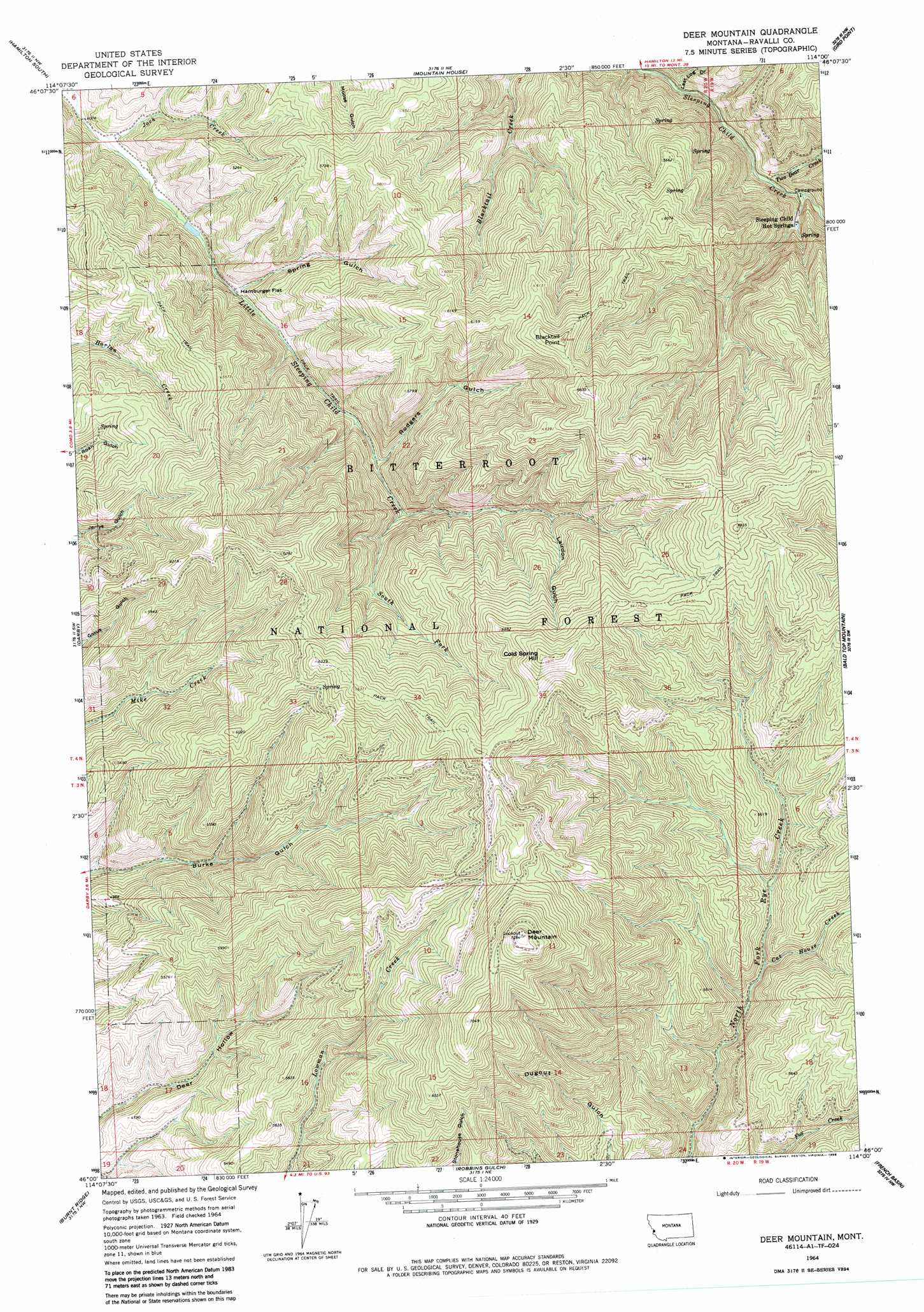
USGS Topo Quad 46114a1 - 1:24,000 scale
| Topo Map Name: | Deer Mountain |
| USGS Topo Quad ID: | 46114a1 |
| Print Size: | ca. 21 1/4" wide x 27" high |
| Southeast Coordinates: | 46° N latitude / 114° W longitude |
| Map Center Coordinates: | 46.0625° N latitude / 114.0625° W longitude |
| U.S. State: | MT |
| Filename: | o46114a1.jpg |
| Download Map JPG Image: | Deer Mountain topo map 1:24,000 scale |
| Map Type: | Topographic |
| Topo Series: | 7.5´ |
| Map Scale: | 1:24,000 |
| Source of Map Images: | United States Geological Survey (USGS) |
| Alternate Map Versions: |
Deer Mountain MT 1964, updated 1968 Download PDF Buy paper map Deer Mountain MT 1964, updated 1986 Download PDF Buy paper map Deer Mountain MT 1998, updated 2002 Download PDF Buy paper map Deer Mountain MT 2011 Download PDF Buy paper map Deer Mountain MT 2014 Download PDF Buy paper map |
| FStopo: | US Forest Service topo Deer Mountain is available: Download FStopo PDF Download FStopo TIF |
1:24,000 Topo Quads surrounding Deer Mountain
Printz Ridge |
Hamilton North |
Corvallis |
Willow Mountain |
Burnt Fork Lake |
Ward Mountain |
Hamilton South |
Mountain House |
Gird Point |
Skalkaho Pass |
Como Peaks |
Darby |
Deer Mountain |
Bald Top Mountain |
Kent Peak |
Trapper Peak |
Burnt Ridge |
Robbins Gulch |
French Basin |
Jennings Camp Creek |
Boulder Peak |
Piquett Creek |
Medicine Hot Springs |
Sula |
Schultz Saddle |
> Back to 46114a1 at 1:100,000 scale
> Back to 46114a1 at 1:250,000 scale
> Back to U.S. Topo Maps home
Deer Mountain topo map: Gazetteer
Deer Mountain: Flats
Hamburger Flat elevation 1345m 4412′Deer Mountain: Gaps
Bobcat Saddle elevation 1980m 6496′Deer Mountain: Springs
04N19W07DCD_01 Spring elevation 1726m 5662′04N19W07DCD_02 Spring elevation 1726m 5662′
Cold Springs elevation 2008m 6587′
Sleeping Child Hot Springs elevation 1415m 4642′
Deer Mountain: Streams
Cat House Creek elevation 1502m 4927′Jack Creek elevation 1285m 4215′
South Fork Little Sleeping Child Creek elevation 1478m 4849′
Two Bear Creek elevation 1372m 4501′
Deer Mountain: Summits
Blacktail Point elevation 1963m 6440′Cold Spring Hill elevation 2087m 6847′
Deer Mountain elevation 2222m 7290′
Harlan Point elevation 1953m 6407′
Deer Mountain: Valleys
Lairdon Gulch elevation 1638m 5374′Last Log Draw elevation 1338m 4389′
Rodgers Gulch elevation 1435m 4708′
Spring Gulch elevation 1346m 4416′
Deer Mountain digital topo map on disk
Buy this Deer Mountain topo map showing relief, roads, GPS coordinates and other geographical features, as a high-resolution digital map file on DVD: