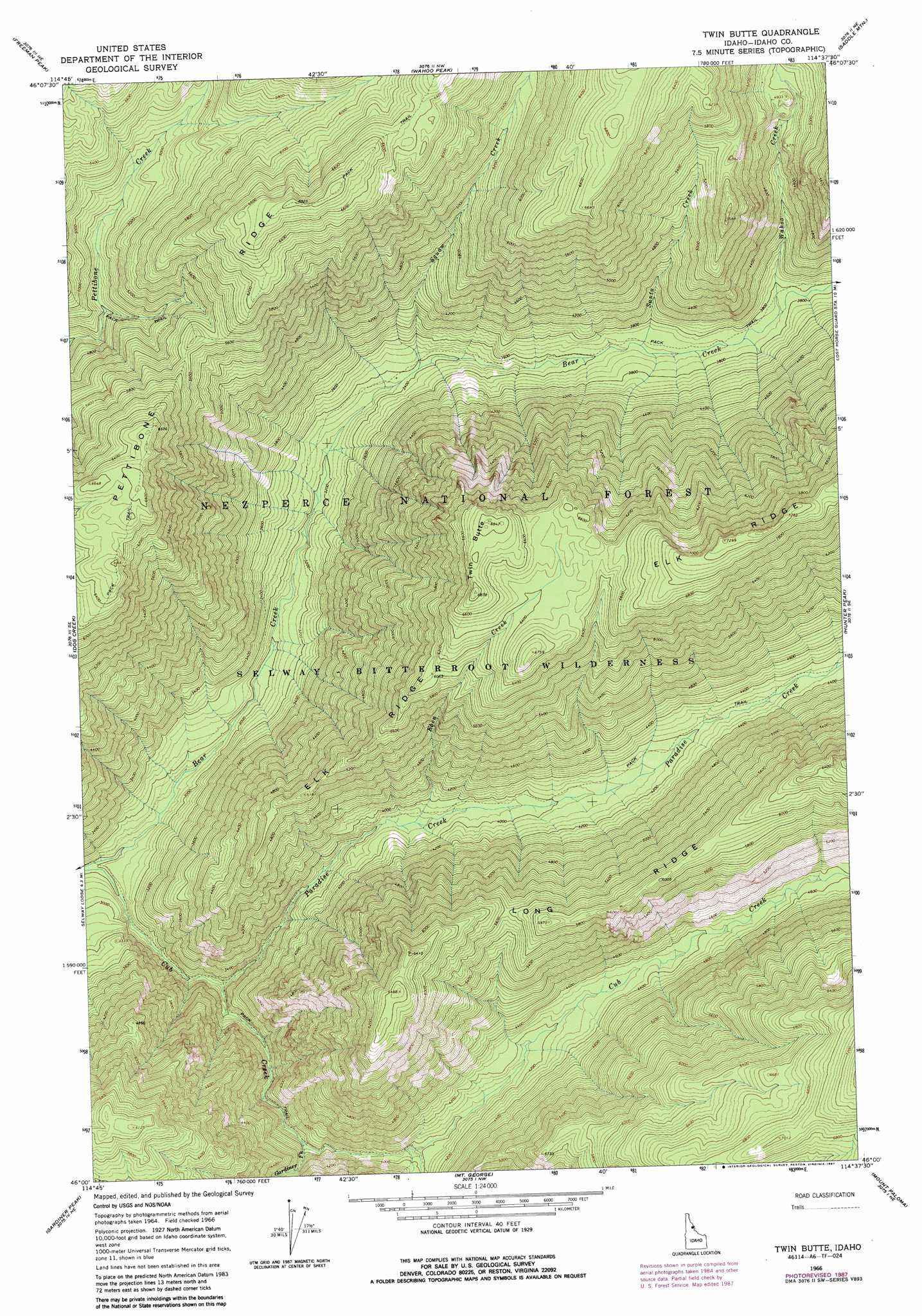
Twin Butte Topo Map Idaho
To zoom in, hover over the map of Twin Butte
USGS Topo Quad 46114a6 - 1:24,000 scale
| Topo Map Name: | Twin Butte |
| USGS Topo Quad ID: | 46114a6 |
| Print Size: | ca. 21 1/4" wide x 27" high |
| Southeast Coordinates: | 46° N latitude / 114.625° W longitude |
| Map Center Coordinates: | 46.0625° N latitude / 114.6875° W longitude |
| U.S. State: | ID |
| Filename: | o46114a6.jpg |
| Download Map JPG Image: | Twin Butte topo map 1:24,000 scale |
| Map Type: | Topographic |
| Topo Series: | 7.5´ |
| Map Scale: | 1:24,000 |
| Source of Map Images: | United States Geological Survey (USGS) |
| Alternate Map Versions: |
Twin Butte ID 1966, updated 1968 Download PDF Buy paper map Twin Butte ID 1966, updated 1987 Download PDF Buy paper map Twin Butte ID 1995, updated 1999 Download PDF Buy paper map Twin Butte ID 2011 Download PDF Buy paper map Twin Butte ID 2013 Download PDF Buy paper map |
| FStopo: | US Forest Service topo Twin Butte is available: Download FStopo PDF Download FStopo TIF |
1:24,000 Topo Quads surrounding Twin Butte
Mcconnell Mountain |
Hungry Rock |
Cedar Ridge |
Jeanette Mountain |
Blodgett Mountain |
Shissler Peak |
Freeman Peak |
Wahoo Peak |
Saddle Mountain |
Tenmile Lake |
Moose Ridge |
Dog Creek |
Twin Butte |
Hunter Peak |
El Capitan |
Wylies Peak |
Gardiner Peak |
Mount George |
Mount Paloma |
Tin Cup Lake |
Three Prong Mountain |
Spot Mountain |
Burnt Strip Mountain |
Watchtower Peak |
Mount Jerusalem |
> Back to 46114a1 at 1:100,000 scale
> Back to 46114a1 at 1:250,000 scale
> Back to U.S. Topo Maps home
Twin Butte topo map: Gazetteer
Twin Butte: Ridges
Pettibone Ridge elevation 1722m 5649′Twin Butte: Streams
Brushy Fork Creek elevation 1206m 3956′Eben Creek elevation 1183m 3881′
Fry Pan Creek elevation 1205m 3953′
Gardiner Fork elevation 1131m 3710′
Paradise Creek elevation 939m 3080′
Santa Creek elevation 1122m 3681′
Squaw Creek elevation 1036m 3398′
Wahoo Creek elevation 1147m 3763′
Twin Butte: Summits
Twin Butte elevation 2092m 6863′Twin Butte digital topo map on disk
Buy this Twin Butte topo map showing relief, roads, GPS coordinates and other geographical features, as a high-resolution digital map file on DVD: