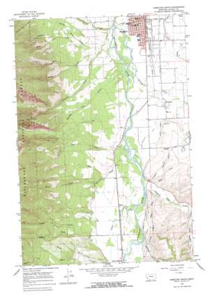
Hamilton South Topo Map Montana
To zoom in, hover over the map of Hamilton South
USGS Topo Quad 46114b2 - 1:24,000 scale
| Topo Map Name: | Hamilton South |
| USGS Topo Quad ID: | 46114b2 |
| Print Size: | ca. 21 1/4" wide x 27" high |
| Southeast Coordinates: | 46.125° N latitude / 114.125° W longitude |
| Map Center Coordinates: | 46.1875° N latitude / 114.1875° W longitude |
| U.S. State: | MT |
| Filename: | o46114b2.jpg |
| Download Map JPG Image: | Hamilton South topo map 1:24,000 scale |
| Map Type: | Topographic |
| Topo Series: | 7.5´ |
| Map Scale: | 1:24,000 |
| Source of Map Images: | United States Geological Survey (USGS) |
| Alternate Map Versions: |
Hamilton South MT 1964, updated 1968 Download PDF Buy paper map Hamilton South MT 1964, updated 1968 Download PDF Buy paper map Hamilton South MT 1998, updated 2002 Download PDF Buy paper map Hamilton South MT 2011 Download PDF Buy paper map Hamilton South MT 2014 Download PDF Buy paper map |
| FStopo: | US Forest Service topo Hamilton South is available: Download FStopo PDF Download FStopo TIF |
1:24,000 Topo Quads surrounding Hamilton South
> Back to 46114a1 at 1:100,000 scale
> Back to 46114a1 at 1:250,000 scale
> Back to U.S. Topo Maps home
Hamilton South topo map: Gazetteer
Hamilton South: Airports
Garlick Heliport elevation 1105m 3625′Hamilton South: Canals
Hedge Ditch elevation 1126m 3694′Republican Ditch elevation 1107m 3631′
Hamilton South: Parks
American Legion Park elevation 1089m 3572′Kiwanis Park elevation 1086m 3562′
Hamilton South: Populated Places
Big Sky Mobile Home Park elevation 1111m 3645′Charlos Heights elevation 1142m 3746′
Curdys Cove elevation 1110m 3641′
Grantsdale elevation 1120m 3674′
Hamilton elevation 1088m 3569′
Hamilton Mobile Home Park elevation 1095m 3592′
Leisure Village elevation 1092m 3582′
Ward elevation 1131m 3710′
Westana Mobile Home Park elevation 1103m 3618′
Hamilton South: Post Offices
Grantsdale Post Office elevation 1120m 3674′Hamilton Post Office elevation 1088m 3569′
Ward Post Office (historical) elevation 1131m 3710′
Hamilton South: Streams
Barley Creek elevation 1107m 3631′Bear Creek elevation 1119m 3671′
Camas Creek elevation 1120m 3674′
Canyon Creek elevation 1080m 3543′
Gold Creek elevation 1108m 3635′
Hayes Creek elevation 1135m 3723′
Hyatt Creek elevation 1117m 3664′
Judd Creek elevation 1106m 3628′
Little Sleeping Child Creek elevation 1159m 3802′
Middle Fork Gold Creek elevation 1183m 3881′
North Fork Gold Creek elevation 1124m 3687′
North Fork Hayes Creek elevation 1175m 3854′
North Fork Owings Creek elevation 1156m 3792′
Owings Creek elevation 1095m 3592′
Roaring Lion Creek elevation 1087m 3566′
Sawdust Creek elevation 1092m 3582′
Sawtooth Creek elevation 1083m 3553′
Skalkaho Creek elevation 1091m 3579′
Sleeping Child Creek elevation 1116m 3661′
Spring Creek elevation 1211m 3973′
Hamilton South: Summits
Goat Mountain elevation 1822m 5977′Hamilton South: Trails
Ward Mountain Trail elevation 1888m 6194′Hamilton South: Valleys
Coyote Coulee elevation 1150m 3772′McKinney Gulch elevation 1137m 3730′
Rattlesnake Gulch elevation 1253m 4110′
Hamilton South: Wells
04N21W01CBCA01 Well elevation 1171m 3841′05N20W07BC__01 Well elevation 1107m 3631′
05N20W07CA__01 Well elevation 1114m 3654′
05N20W18BB__01 Well elevation 1111m 3645′
05N20W18CACC01 Well elevation 1124m 3687′
05N20W18CBCD01 Well elevation 1120m 3674′
05N20W18CBDC01 Well elevation 1121m 3677′
05N20W18CDDB01 Well elevation 1152m 3779′
05N21W02AAAB01 Well elevation 1100m 3608′
05N21W15AABD01 Well elevation 1198m 3930′
05N21W15AADB01 Well elevation 1195m 3920′
05N21W15AADC01 Well elevation 1196m 3923′
05N21W15BDB_01 Well elevation 1248m 4094′
05N21W24AA__01 Well elevation 1119m 3671′
05N21W34CBBB01 Well elevation 1258m 4127′
05N21W34CCAD01 Well elevation 1220m 4002′
05N21W36DCC_01 Well elevation 1129m 3704′
05N21W36DCC_02 Well elevation 1129m 3704′
06N20W30BC__01 Well elevation 1089m 3572′
06N20W30DBCC01 Well elevation 1092m 3582′
06N21W25AD__01 Well elevation 1088m 3569′
06N21W25DBAA01 Well elevation 1088m 3569′
06N21W26CBAB01 Well elevation 1133m 3717′
06N21W26DBAD01 Well elevation 1103m 3618′
06N21W26DBD_01 Well elevation 1105m 3625′
06N21W26DBDD01 Well elevation 1100m 3608′
06N21W27ADBC01 Well elevation 1170m 3838′
06N21W35ABAB01 Well elevation 1106m 3628′
06N21W35BABD01 Well elevation 1122m 3681′
06N21W36DD__01 Well elevation 1092m 3582′
Hamilton South digital topo map on disk
Buy this Hamilton South topo map showing relief, roads, GPS coordinates and other geographical features, as a high-resolution digital map file on DVD:


