Wahoo Peak Topo Map Idaho
To zoom in, hover over the map of Wahoo Peak
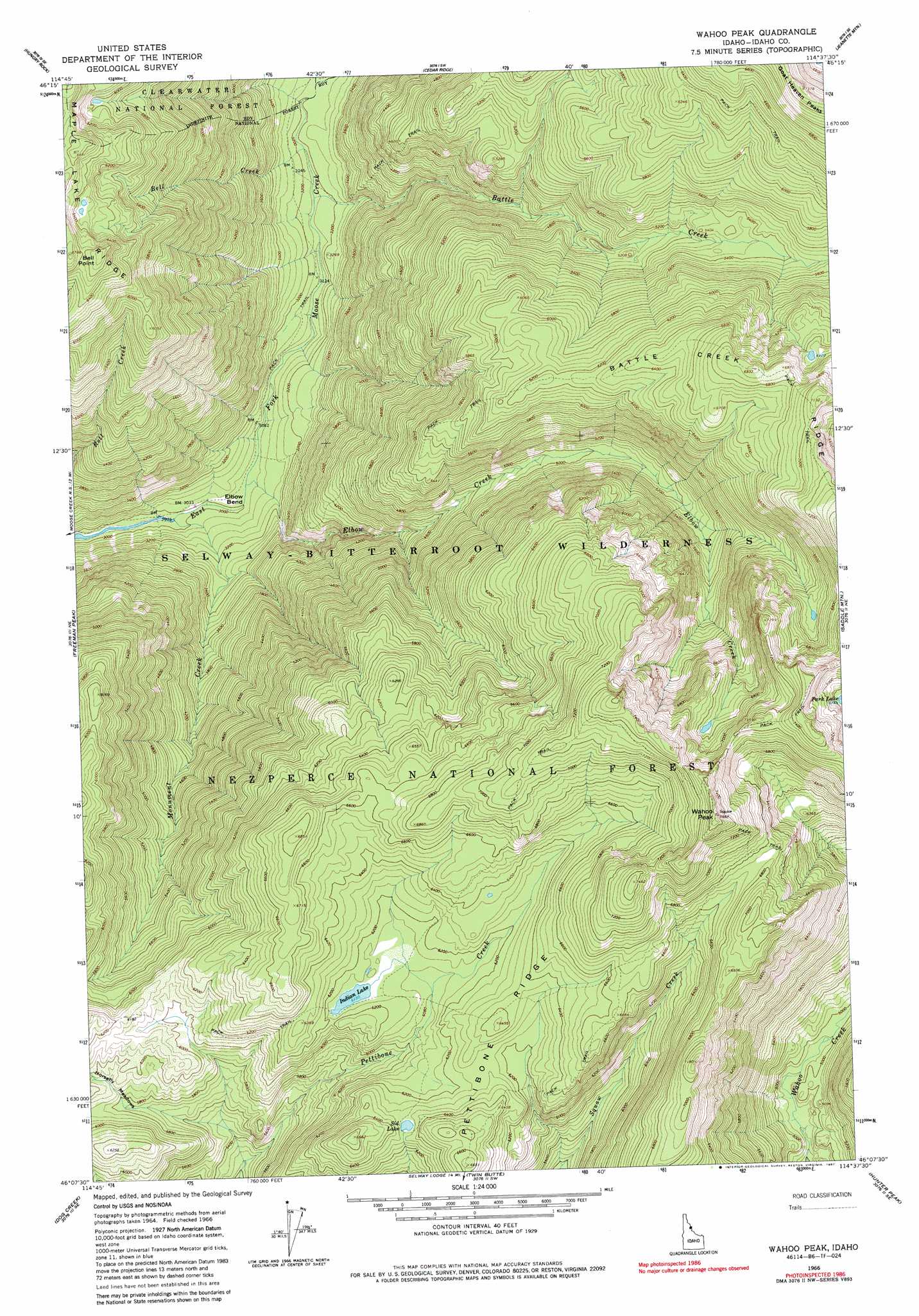
USGS Topo Quad 46114b6 - 1:24,000 scale
| Topo Map Name: | Wahoo Peak |
| USGS Topo Quad ID: | 46114b6 |
| Print Size: | ca. 21 1/4" wide x 27" high |
| Southeast Coordinates: | 46.125° N latitude / 114.625° W longitude |
| Map Center Coordinates: | 46.1875° N latitude / 114.6875° W longitude |
| U.S. State: | ID |
| Filename: | o46114b6.jpg |
| Download Map JPG Image: | Wahoo Peak topo map 1:24,000 scale |
| Map Type: | Topographic |
| Topo Series: | 7.5´ |
| Map Scale: | 1:24,000 |
| Source of Map Images: | United States Geological Survey (USGS) |
| Alternate Map Versions: |
Wahoo Peak ID 1966, updated 1968 Download PDF Buy paper map Wahoo Peak ID 1966, updated 1983 Download PDF Buy paper map Wahoo Peak ID 1966, updated 1987 Download PDF Buy paper map Wahoo Peak ID 1995, updated 1999 Download PDF Buy paper map Wahoo Peak ID 2011 Download PDF Buy paper map Wahoo Peak ID 2013 Download PDF Buy paper map |
| FStopo: | US Forest Service topo Wahoo Peak is available: Download FStopo PDF Download FStopo TIF |
1:24,000 Topo Quads surrounding Wahoo Peak
Bear Mountain |
Tom Beal Peak |
Grave Peak |
Savage Ridge |
White Sand Lake |
Mcconnell Mountain |
Hungry Rock |
Cedar Ridge |
Jeanette Mountain |
Blodgett Mountain |
Shissler Peak |
Freeman Peak |
Wahoo Peak |
Saddle Mountain |
Tenmile Lake |
Moose Ridge |
Dog Creek |
Twin Butte |
Hunter Peak |
El Capitan |
Wylies Peak |
Gardiner Peak |
Mount George |
Mount Paloma |
Tin Cup Lake |
> Back to 46114a1 at 1:100,000 scale
> Back to 46114a1 at 1:250,000 scale
> Back to U.S. Topo Maps home
Wahoo Peak topo map: Gazetteer
Wahoo Peak: Bends
Elbow Bend elevation 916m 3005′Wahoo Peak: Flats
Horsefly Meadows elevation 1805m 5921′Wahoo Peak: Lakes
Indian Lake elevation 1870m 6135′Sid Lake elevation 1923m 6309′
Wahoo Peak: Ridges
Battle Creek Ridge elevation 2177m 7142′Wahoo Peak: Streams
Battle Creek elevation 964m 3162′Bell Creek elevation 969m 3179′
Cedar Creek elevation 986m 3234′
Elbow Creek elevation 919m 3015′
Monument Creek elevation 903m 2962′
Wahoo Peak: Summits
Wahoo Peak elevation 2313m 7588′Wahoo Peak digital topo map on disk
Buy this Wahoo Peak topo map showing relief, roads, GPS coordinates and other geographical features, as a high-resolution digital map file on DVD: