Corvallis Topo Map Montana
To zoom in, hover over the map of Corvallis
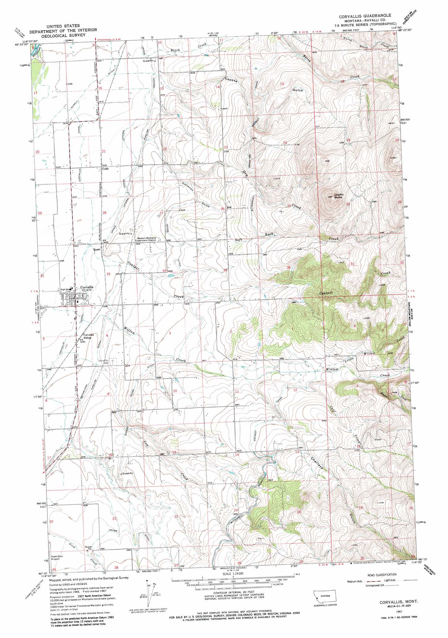
USGS Topo Quad 46114c1 - 1:24,000 scale
| Topo Map Name: | Corvallis |
| USGS Topo Quad ID: | 46114c1 |
| Print Size: | ca. 21 1/4" wide x 27" high |
| Southeast Coordinates: | 46.25° N latitude / 114° W longitude |
| Map Center Coordinates: | 46.3125° N latitude / 114.0625° W longitude |
| U.S. State: | MT |
| Filename: | o46114c1.jpg |
| Download Map JPG Image: | Corvallis topo map 1:24,000 scale |
| Map Type: | Topographic |
| Topo Series: | 7.5´ |
| Map Scale: | 1:24,000 |
| Source of Map Images: | United States Geological Survey (USGS) |
| Alternate Map Versions: |
Corvallis MT 1967, updated 1972 Download PDF Buy paper map Corvallis MT 1967, updated 1986 Download PDF Buy paper map Corvallis MT 1998, updated 2002 Download PDF Buy paper map Corvallis MT 2011 Download PDF Buy paper map Corvallis MT 2014 Download PDF Buy paper map |
| FStopo: | US Forest Service topo Corvallis is available: Download FStopo PDF Download FStopo TIF |
1:24,000 Topo Quads surrounding Corvallis
Saint Joseph Peak |
Saint Mary Peak |
Stevensville |
Grayhorse Creek |
Cleveland Mountain |
Gash Point |
Victor |
Bing |
Corley Gulch |
Sawmill Saddle |
Printz Ridge |
Hamilton North |
Corvallis |
Willow Mountain |
Burnt Fork Lake |
Ward Mountain |
Hamilton South |
Mountain House |
Gird Point |
Skalkaho Pass |
Como Peaks |
Darby |
Deer Mountain |
Bald Top Mountain |
Kent Peak |
> Back to 46114a1 at 1:100,000 scale
> Back to 46114a1 at 1:250,000 scale
> Back to U.S. Topo Maps home
Corvallis topo map: Gazetteer
Corvallis: Airports
Ravalli County Airport elevation 1105m 3625′Corvallis: Canals
Bitterroot Irrigation District Canal elevation 1172m 3845′Corvallis Canal elevation 1064m 3490′
Lower Lateral elevation 1051m 3448′
Upper Lateral elevation 1060m 3477′
Corvallis: Populated Places
Cobb elevation 1048m 3438′Corvallis elevation 1061m 3480′
Corvallis Mobile Home Park elevation 1061m 3480′
Ponderosa Mobile Home Park elevation 1190m 3904′
Quast elevation 1058m 3471′
Corvallis: Post Offices
Corvallis Post Office elevation 1061m 3480′Corvallis: Streams
Birch Creek elevation 1046m 3431′Calf Creek elevation 1165m 3822′
Coalpit Creek elevation 1065m 3494′
Cow Creek elevation 1064m 3490′
Dry Creek elevation 1056m 3464′
Little Willow Creek elevation 1184m 3884′
Soft Rock Creek elevation 1073m 3520′
Stuart Creek elevation 1230m 4035′
Corvallis: Summits
Chaffin Butte elevation 1514m 4967′Corvallis: Valleys
Charleys Gulch elevation 1145m 3756′Coyote Gulch elevation 1055m 3461′
Holloron Gulch elevation 1075m 3526′
Spring Gulch elevation 1082m 3549′
Corvallis: Wells
06N20W01CDCD01 Well elevation 1175m 3854′06N20W03ABBB01 Well elevation 1091m 3579′
06N20W03BD__01 Well elevation 1095m 3592′
06N20W04ADCC01 Well elevation 1084m 3556′
06N20W04BC__01 Well elevation 1065m 3494′
06N20W04CC__01 Well elevation 1068m 3503′
06N20W08AA__01 Well elevation 1068m 3503′
06N20W10CB__01 Well elevation 1130m 3707′
06N20W14BAAD01 Well elevation 1171m 3841′
06N20W14BBBB01 Well elevation 1157m 3795′
06N20W15ADAD01 Well elevation 1149m 3769′
07N20W11DADD01 Well elevation 1125m 3690′
07N20W16AB__01 Well elevation 1039m 3408′
07N20W16AC__01 Well elevation 1041m 3415′
07N20W17AA__01 Well elevation 1038m 3405′
07N20W17DAD_01 Well elevation 1041m 3415′
07N20W20DD__01 Well elevation 1047m 3435′
07N20W21AB__01 Well elevation 1045m 3428′
07N20W21BA__01 Well elevation 1045m 3428′
07N20W21CD__01 Well elevation 1048m 3438′
07N20W22CB__01 Well elevation 1055m 3461′
07N20W22DA__01 Well elevation 1103m 3618′
07N20W23DCBB01 Well elevation 1127m 3697′
07N20W26CDD_01 Well elevation 1129m 3704′
07N20W28BC__01 Well elevation 1051m 3448′
07N20W32DD__01 Well elevation 1062m 3484′
07N20W32DDD_02 Well elevation 1061m 3480′
07N20W36BBCC01 Well elevation 1185m 3887′
Corvallis digital topo map on disk
Buy this Corvallis topo map showing relief, roads, GPS coordinates and other geographical features, as a high-resolution digital map file on DVD: