Victor Topo Map Montana
To zoom in, hover over the map of Victor
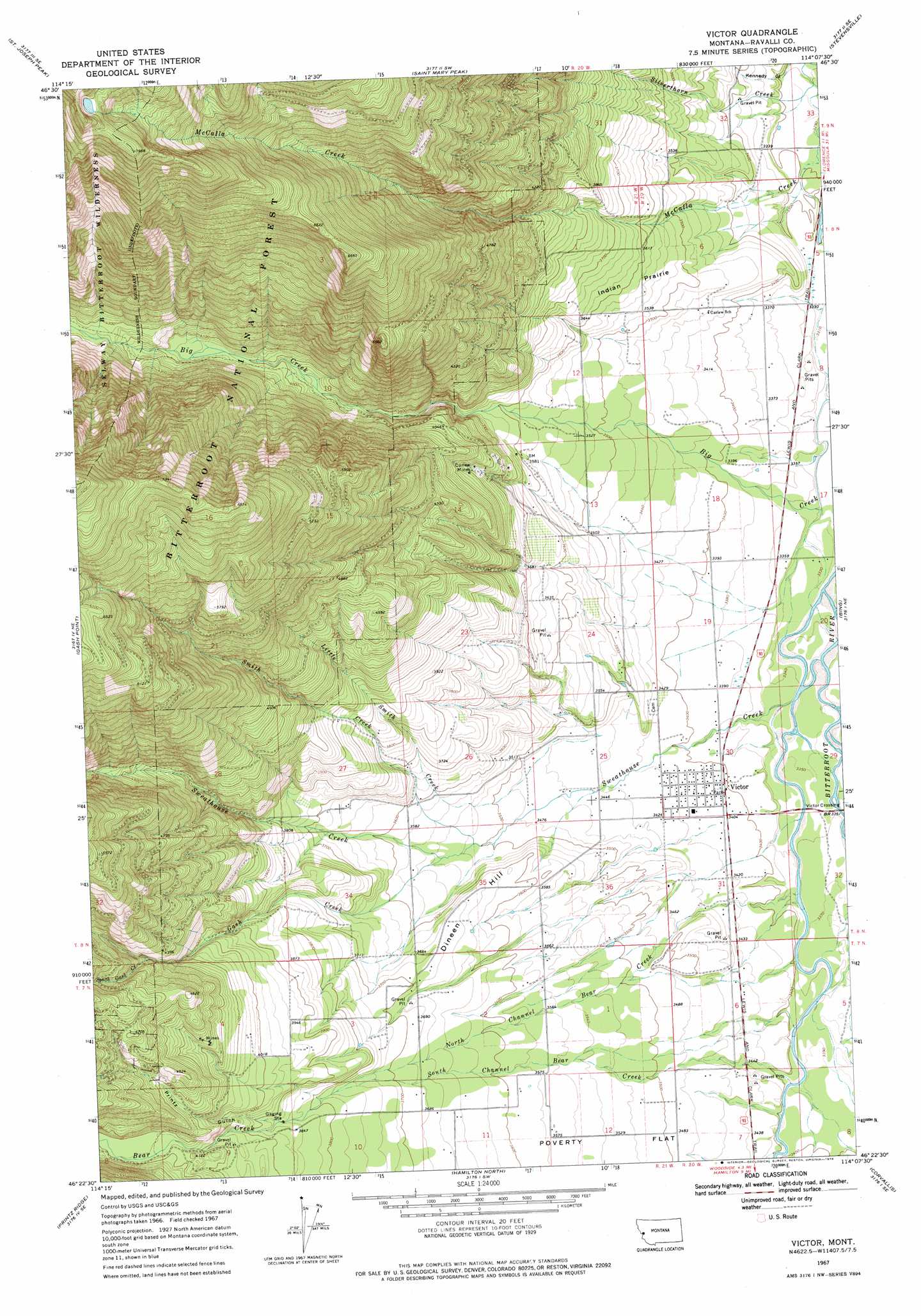
USGS Topo Quad 46114d2 - 1:24,000 scale
| Topo Map Name: | Victor |
| USGS Topo Quad ID: | 46114d2 |
| Print Size: | ca. 21 1/4" wide x 27" high |
| Southeast Coordinates: | 46.375° N latitude / 114.125° W longitude |
| Map Center Coordinates: | 46.4375° N latitude / 114.1875° W longitude |
| U.S. State: | MT |
| Filename: | o46114d2.jpg |
| Download Map JPG Image: | Victor topo map 1:24,000 scale |
| Map Type: | Topographic |
| Topo Series: | 7.5´ |
| Map Scale: | 1:24,000 |
| Source of Map Images: | United States Geological Survey (USGS) |
| Alternate Map Versions: |
Victor MT 1967, updated 1972 Download PDF Buy paper map Victor MT 1998, updated 2002 Download PDF Buy paper map Victor MT 2011 Download PDF Buy paper map Victor MT 2014 Download PDF Buy paper map |
| FStopo: | US Forest Service topo Victor is available: Download FStopo PDF Download FStopo TIF |
1:24,000 Topo Quads surrounding Victor
West Fork Butte |
Dick Creek |
Carlton Lake |
Florence |
Davis Point |
Ranger Peak |
Saint Joseph Peak |
Saint Mary Peak |
Stevensville |
Grayhorse Creek |
White Sand Lake |
Gash Point |
Victor |
Bing |
Corley Gulch |
Blodgett Mountain |
Printz Ridge |
Hamilton North |
Corvallis |
Willow Mountain |
Tenmile Lake |
Ward Mountain |
Hamilton South |
Mountain House |
Gird Point |
> Back to 46114a1 at 1:100,000 scale
> Back to 46114a1 at 1:250,000 scale
> Back to U.S. Topo Maps home
Victor topo map: Gazetteer
Victor: Bridges
Victor Bridge elevation 1023m 3356′Victor: Dams
McCalla Lake Dam elevation 2355m 7726′Victor: Flats
Indian Prairie elevation 1098m 3602′Victor: Mines
Blue Bird Mine elevation 1301m 4268′Curlew Mine elevation 1180m 3871′
Curlew Mines elevation 1182m 3877′
Pleasant View Mine elevation 1272m 4173′
SE SW Section 15 Mine elevation 1558m 5111′
Victor: Parks
Victor Park elevation 1039m 3408′Victor: Populated Places
Victor elevation 1041m 3415′Victor: Post Offices
Victor Post Office elevation 1041m 3415′Victor: Streams
Bear Creek elevation 1152m 3779′Gash Creek elevation 1078m 3536′
Little Smith Creek elevation 1053m 3454′
North Channel Bear Creek elevation 1025m 3362′
Silverthorn Creek elevation 1001m 3284′
Smith Creek elevation 1070m 3510′
South Channel Bear Creek elevation 1034m 3392′
South Gash Creek elevation 1306m 4284′
Sweathouse Creek elevation 1019m 3343′
Victor: Summits
Dineen Hill elevation 1105m 3625′Victor: Valleys
Fulkerson Gulch elevation 1049m 3441′Kennedy Gulch elevation 1003m 3290′
Printz Gulch elevation 1177m 3861′
Victor: Wells
07N20W07BA__01 Well elevation 1057m 3467′07N21W11BD__01 Well elevation 1110m 3641′
08N20W05BA__01 Well elevation 1007m 3303′
08N20W05CC__01 Well elevation 1021m 3349′
08N20W06CC__01 Well elevation 1076m 3530′
08N20W07AB__01 Well elevation 1038m 3405′
08N20W18DD__01 Well elevation 1028m 3372′
08N20W19BAAD03 Well elevation 1037m 3402′
08N20W30CA__01 Well elevation 1039m 3408′
08N20W30DC__01 Well elevation 1039m 3408′
08N20W31DDD_01 Well elevation 1039m 3408′
08N21W24ACDA01 Well elevation 1063m 3487′
08N21W24BCBA01 Well elevation 1111m 3645′
08N21W26DD__01 Well elevation 1062m 3484′
08N21W27DCB_01 Well elevation 1114m 3654′
Victor digital topo map on disk
Buy this Victor topo map showing relief, roads, GPS coordinates and other geographical features, as a high-resolution digital map file on DVD: