Stevensville Topo Map Montana
To zoom in, hover over the map of Stevensville
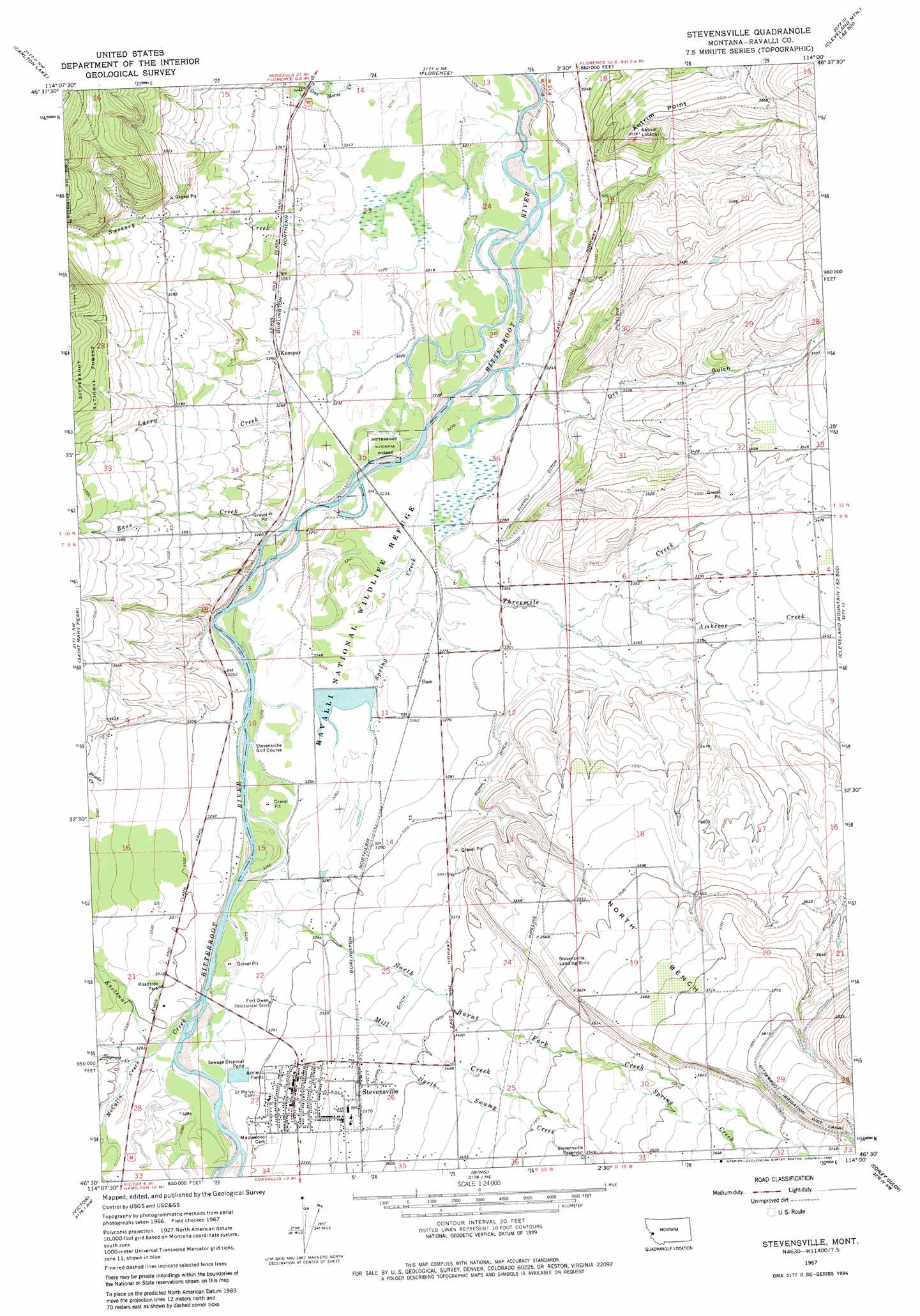
USGS Topo Quad 46114e1 - 1:24,000 scale
| Topo Map Name: | Stevensville |
| USGS Topo Quad ID: | 46114e1 |
| Print Size: | ca. 21 1/4" wide x 27" high |
| Southeast Coordinates: | 46.5° N latitude / 114° W longitude |
| Map Center Coordinates: | 46.5625° N latitude / 114.0625° W longitude |
| U.S. State: | MT |
| Filename: | o46114e1.jpg |
| Download Map JPG Image: | Stevensville topo map 1:24,000 scale |
| Map Type: | Topographic |
| Topo Series: | 7.5´ |
| Map Scale: | 1:24,000 |
| Source of Map Images: | United States Geological Survey (USGS) |
| Alternate Map Versions: |
Stevensville MT 1967, updated 1972 Download PDF Buy paper map Stevensville MT 1967, updated 1980 Download PDF Buy paper map Stevensville MT 1998, updated 2002 Download PDF Buy paper map Stevensville MT 2011 Download PDF Buy paper map Stevensville MT 2014 Download PDF Buy paper map |
| FStopo: | US Forest Service topo Stevensville is available: Download FStopo PDF Download FStopo TIF |
1:24,000 Topo Quads surrounding Stevensville
Camp Creek |
Blue Mountain |
Southwest Missoula |
Southeast Missoula |
Bonner |
Dick Creek |
Carlton Lake |
Florence |
Davis Point |
Elk Mountain |
Saint Joseph Peak |
Saint Mary Peak |
Stevensville |
Grayhorse Creek |
Cleveland Mountain |
Gash Point |
Victor |
Bing |
Corley Gulch |
Sawmill Saddle |
Printz Ridge |
Hamilton North |
Corvallis |
Willow Mountain |
Burnt Fork Lake |
> Back to 46114e1 at 1:100,000 scale
> Back to 46114a1 at 1:250,000 scale
> Back to U.S. Topo Maps home
Stevensville topo map: Gazetteer
Stevensville: Airports
Ckye Field elevation 1086m 3562′Lee Metcalf National Wildlife Refuge Airport elevation 994m 3261′
Stevensville Airport elevation 1092m 3582′
Stevensville: Benches
North Bench elevation 1113m 3651′Stevensville: Canals
Supply Ditch elevation 1029m 3375′Stevensville: Capes
Antrim Point elevation 1068m 3503′Stevensville: Dams
Auriga Dam elevation 995m 3264′Stevensville Sewage Lagoon Dam elevation 1001m 3284′
Stevensville: Parks
Fort Owen Historical Marker elevation 1009m 3310′Fort Owen State Park elevation 1003m 3290′
Lee Metcalf National Wildlife Refuge elevation 989m 3244′
Lewis and Clark Park elevation 1017m 3336′
Stevensville: Populated Places
Apple Blossom Court elevation 1026m 3366′Bitter Root (historical) elevation 1023m 3356′
Bitterroot Court elevation 1061m 3480′
Kenspur elevation 993m 3257′
Stevensville elevation 1013m 3323′
Sweeney Creek (historical) elevation 998m 3274′
Stevensville: Post Offices
Bitter Root Post Office (historical) elevation 1023m 3356′Fort Owen Post Office (historical) elevation 1003m 3290′
Stevensville Post Office elevation 1013m 3323′
Stevensville: Reservoirs
Stevensville Reservoir elevation 1084m 3556′Stevensville: Springs
10N19W30CD__01 Spring elevation 1012m 3320′Stevensville: Streams
Ambrose Creek elevation 1019m 3343′Bass Creek elevation 989m 3244′
Brooks Creek elevation 1029m 3375′
Iron Cap Creek elevation 1164m 3818′
Kootenai Creek elevation 995m 3264′
Larry Creek elevation 985m 3231′
McCalla Creek elevation 998m 3274′
Mill Creek elevation 994m 3261′
Mill Fork Creek elevation 997m 3270′
North Burnt Fork Creek elevation 992m 3254′
North Swamp Creek elevation 1030m 3379′
Sharrott Creek elevation 1001m 3284′
South Swamp Creek elevation 1001m 3284′
Spring Creek elevation 1080m 3543′
Spring Creek elevation 985m 3231′
Sweeney Creek elevation 976m 3202′
Threemile Creek elevation 981m 3218′
Stevensville: Valleys
Dry Gulch elevation 1011m 3316′Stevensville: Wells
09N19W05AD__01 Well elevation 1056m 3464′09N19W05CA__01 Well elevation 1043m 3421′
09N19W06CA__01 Well elevation 1019m 3343′
09N19W29CC__01 Well elevation 1117m 3664′
09N19W30CC__01 Well elevation 1085m 3559′
09N20W01AC__01 Well elevation 1011m 3316′
09N20W01DA__01 Well elevation 1013m 3323′
09N20W04AB__01 Well elevation 1056m 3464′
09N20W10AD__02 Well elevation 992m 3254′
09N20W10BC__01 Well elevation 1012m 3320′
09N20W11ABCC01 Well elevation 995m 3264′
09N20W12BBBB01 Well elevation 1000m 3280′
09N20W12CB__01 Well elevation 1002m 3287′
09N20W15CA__02 Well elevation 995m 3264′
09N20W15DD__01 Well elevation 998m 3274′
09N20W16DC__01 Well elevation 1017m 3336′
09N20W21AD__01 Well elevation 1006m 3300′
09N20W21ADB_01 Well elevation 1008m 3307′
09N20W21ADB_02 Well elevation 1008m 3307′
09N20W23AD__01 Well elevation 1031m 3382′
09N20W23DA__01 Well elevation 1032m 3385′
09N20W25BB__01 Well elevation 1047m 3435′
09N20W26BA__01 Well elevation 1027m 3369′
09N20W26BA__03 Well elevation 1027m 3369′
09N20W26BA__04 Well elevation 1027m 3369′
09N20W26BACC01 Well elevation 1026m 3366′
09N20W26BACC02 Well elevation 1026m 3366′
09N20W27AACC01 Well elevation 1012m 3320′
09N20W27ABCC01 Well elevation 1008m 3307′
09N20W27CD__01 Well elevation 1003m 3290′
09N20W27DBCD01 Well elevation 1012m 3320′
09N20W27DCBA01 Well elevation 1012m 3320′
09N20W27DCBB01 Well elevation 1010m 3313′
09N20W27DDBA01 Well elevation 1017m 3336′
09N20W28BD__01 Well elevation 1001m 3284′
09N20W28DB__01 Well elevation 1001m 3284′
10N19W17DBCA01 Well elevation 1069m 3507′
10N19W18CA__01 Well elevation 996m 3267′
10N19W29CC__01 Well elevation 1033m 3389′
10N20W13CC__01 Well elevation 979m 3211′
10N20W15DC__01 Well elevation 1009m 3310′
10N20W22BC__01 Well elevation 1032m 3385′
10N20W22CC__01 Well elevation 1026m 3366′
10N20W23CB__01 Well elevation 988m 3241′
10N20W26AB__01 Well elevation 984m 3228′
10N20W27AD__01 Well elevation 991m 3251′
10N20W34CD__01 Well elevation 1017m 3336′
10N20W35BB__01 Well elevation 987m 3238′
Stevensville digital topo map on disk
Buy this Stevensville topo map showing relief, roads, GPS coordinates and other geographical features, as a high-resolution digital map file on DVD: