Saint Joseph Peak Topo Map Montana
To zoom in, hover over the map of Saint Joseph Peak
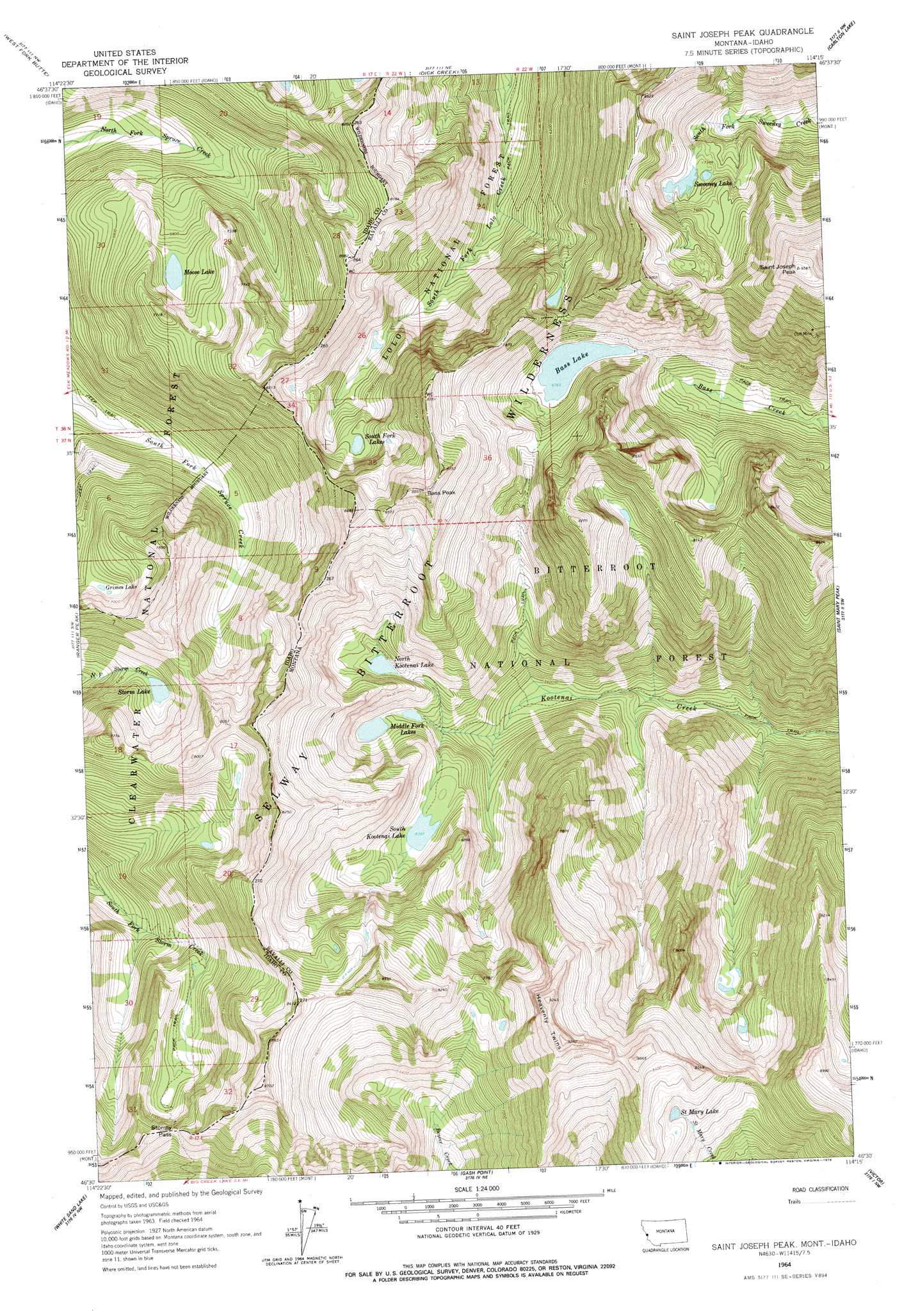
USGS Topo Quad 46114e3 - 1:24,000 scale
| Topo Map Name: | Saint Joseph Peak |
| USGS Topo Quad ID: | 46114e3 |
| Print Size: | ca. 21 1/4" wide x 27" high |
| Southeast Coordinates: | 46.5° N latitude / 114.25° W longitude |
| Map Center Coordinates: | 46.5625° N latitude / 114.3125° W longitude |
| U.S. States: | MT, ID |
| Filename: | o46114e3.jpg |
| Download Map JPG Image: | Saint Joseph Peak topo map 1:24,000 scale |
| Map Type: | Topographic |
| Topo Series: | 7.5´ |
| Map Scale: | 1:24,000 |
| Source of Map Images: | United States Geological Survey (USGS) |
| Alternate Map Versions: |
St. Joseph Peak MT 1964, updated 1967 Download PDF Buy paper map Saint Joseph Peak MT 1998, updated 2002 Download PDF Buy paper map Saint Joseph Peak MT 2011 Download PDF Buy paper map Saint Joseph Peak MT 2014 Download PDF Buy paper map |
| FStopo: | US Forest Service topo Saint Joseph Peak is available: Download FStopo PDF Download FStopo TIF |
1:24,000 Topo Quads surrounding Saint Joseph Peak
Lupine Creek |
Garden Point |
Camp Creek |
Blue Mountain |
Southwest Missoula |
Lolo Hot Springs |
West Fork Butte |
Dick Creek |
Carlton Lake |
Florence |
Roundtop |
Ranger Peak |
Saint Joseph Peak |
Saint Mary Peak |
Stevensville |
Savage Ridge |
White Sand Lake |
Gash Point |
Victor |
Bing |
Jeanette Mountain |
Blodgett Mountain |
Printz Ridge |
Hamilton North |
Corvallis |
> Back to 46114e1 at 1:100,000 scale
> Back to 46114a1 at 1:250,000 scale
> Back to U.S. Topo Maps home
Saint Joseph Peak topo map: Gazetteer
Saint Joseph Peak: Dams
Bass Lake Dam elevation 2085m 6840′Saint Joseph Peak: Gaps
Stormy Pass elevation 2251m 7385′Stormy Pass elevation 2239m 7345′
Saint Joseph Peak: Lakes
Grimes Lake elevation 2078m 6817′Middle Fork Lakes elevation 1824m 5984′
Moose Lake elevation 2007m 6584′
North Kootenai Lake elevation 1922m 6305′
Saint Mary Lake elevation 2373m 7785′
South Fork Lakes elevation 2192m 7191′
South Kootenai Lake elevation 1908m 6259′
Storm Lake elevation 1970m 6463′
Sweeney Lake elevation 2238m 7342′
Saint Joseph Peak: Mines
Cliff Mine elevation 2564m 8412′Saint Joseph Peak: Reservoirs
Bass Lake elevation 2073m 6801′Saint Joseph Peak: Summits
Bass Peak elevation 2670m 8759′Heavenly Twins elevation 2832m 9291′
Saint Joseph Peak elevation 2922m 9586′
Saint Joseph Peak digital topo map on disk
Buy this Saint Joseph Peak topo map showing relief, roads, GPS coordinates and other geographical features, as a high-resolution digital map file on DVD: