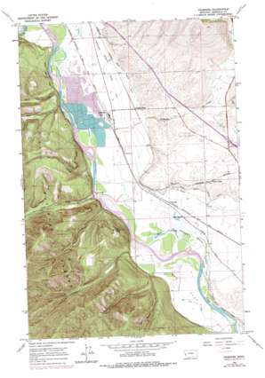
Primrose Topo Map Montana
To zoom in, hover over the map of Primrose
USGS Topo Quad 46114h2 - 1:24,000 scale
| Topo Map Name: | Primrose |
| USGS Topo Quad ID: | 46114h2 |
| Print Size: | ca. 21 1/4" wide x 27" high |
| Southeast Coordinates: | 46.875° N latitude / 114.125° W longitude |
| Map Center Coordinates: | 46.9375° N latitude / 114.1875° W longitude |
| U.S. State: | MT |
| Filename: | o46114h2.jpg |
| Download Map JPG Image: | Primrose topo map 1:24,000 scale |
| Map Type: | Topographic |
| Topo Series: | 7.5´ |
| Map Scale: | 1:24,000 |
| Source of Map Images: | United States Geological Survey (USGS) |
| Alternate Map Versions: |
Primrose MT 1963, updated 1967 Download PDF Buy paper map Primrose MT 1963, updated 1978 Download PDF Buy paper map Primrose MT 1999, updated 2003 Download PDF Buy paper map Primrose MT 2011 Download PDF Buy paper map Primrose MT 2014 Download PDF Buy paper map |
| FStopo: | US Forest Service topo Primrose is available: Download FStopo PDF Download FStopo TIF |
1:24,000 Topo Quads surrounding Primrose
> Back to 46114e1 at 1:100,000 scale
> Back to 46114a1 at 1:250,000 scale
> Back to U.S. Topo Maps home
Primrose topo map: Gazetteer
Primrose: Bridges
Harper Bridge elevation 930m 3051′Primrose: Canals
Grass Valley French Ditch elevation 951m 3120′Primrose: Crossings
Interchange 96 elevation 1002m 3287′Primrose: Flats
Big Flat elevation 942m 3090′Primrose: Guts
Warm Slough elevation 936m 3070′Primrose: Parks
Council Grove State Park elevation 940m 3083′Primrose: Populated Places
Ardrum (historical) elevation 1016m 3333′Grass Valley elevation 964m 3162′
Primrose elevation 937m 3074′
Schilling elevation 933m 3061′
Skyline Trailer Court elevation 965m 3166′
Wagon Wheel Trailer Court elevation 938m 3077′
Primrose: Post Offices
Ardrum Post Office (historical) elevation 1016m 3333′Grass Valley Post Office (historical) elevation 964m 3162′
Primrose: Streams
Albert Creek elevation 926m 3038′Deep Creek elevation 931m 3054′
La Valle Creek elevation 937m 3074′
O'Keefe Creek elevation 928m 3044′
Rock Creek elevation 928m 3044′
Primrose: Valleys
Cyr Gulch elevation 933m 3061′Dog Gulch elevation 1036m 3398′
Dry Gulch elevation 938m 3077′
Little Martin Gulch elevation 997m 3270′
Martin Gulch elevation 940m 3083′
Sherman Gulch elevation 940m 3083′
Primrose: Wells
13N20W04BC__01 Well elevation 946m 3103′13N20W04CB__01 Well elevation 944m 3097′
13N20W06AA__03 Well elevation 937m 3074′
13N20W08CBB_01 Well elevation 940m 3083′
13N20W08DA__01 Well elevation 941m 3087′
13N20W09BA__01 Well elevation 943m 3093′
13N20W17BB__01 Well elevation 943m 3093′
13N20W21BB__01 Well elevation 950m 3116′
13N21W01DCAD01 Well elevation 995m 3264′
13N21W11AADC01 Well elevation 1206m 3956′
14N20W07DB__01 Well elevation 979m 3211′
14N20W07DD__01 Well elevation 981m 3218′
14N20W08DDCC01 Well elevation 1031m 3382′
14N20W09DD__01 Well elevation 990m 3248′
14N20W19BD__01 Well elevation 942m 3090′
14N20W19CB__01 Well elevation 938m 3077′
14N20W20BB__01 Well elevation 959m 3146′
14N20W21BB__01 Well elevation 961m 3152′
14N20W21BD__01 Well elevation 968m 3175′
14N20W28AB__01 Well elevation 995m 3264′
14N20W28DA__01 Well elevation 974m 3195′
14N20W28DBDD01 Well elevation 976m 3202′
14N20W28DCCC01 Well elevation 972m 3188′
14N20W29DCCA01 Well elevation 976m 3202′
14N20W30CC__01 Well elevation 937m 3074′
14N20W31AA__01 Well elevation 961m 3152′
14N20W31BB__01 Well elevation 935m 3067′
14N20W31BD__01 Well elevation 936m 3070′
14N20W31DA__01 Well elevation 937m 3074′
14N20W31DB__01 Well elevation 936m 3070′
14N20W31DD__01 Well elevation 937m 3074′
14N20W32BB__01 Well elevation 952m 3123′
14N20W32CB__01 Well elevation 938m 3077′
14N20W32CB__02 Well elevation 938m 3077′
14N20W32DC__01 Well elevation 939m 3080′
14N20W32DCCA01 Well elevation 939m 3080′
14N20W33CC__01 Well elevation 940m 3083′
14N21W01DDBB01 Well elevation 971m 3185′
14N21W02DC__01 Well elevation 928m 3044′
14N21W11ABAB01 Well elevation 928m 3044′
14N21W11BA__01 Well elevation 928m 3044′
14N21W11CA__01 Well elevation 928m 3044′
14N21W12DB__01 Well elevation 942m 3090′
14N21W13AB__01 Well elevation 937m 3074′
14N21W13BB__01 Well elevation 933m 3061′
14N21W13BB__02 Well elevation 933m 3061′
14N21W13BBAA01 Well elevation 933m 3061′
14N21W13CACC01 Well elevation 934m 3064′
14N21W13CD__01 Well elevation 934m 3064′
14N21W13DB__01 Well elevation 936m 3070′
14N21W13DC__02 Well elevation 936m 3070′
14N21W13DCDA01 Well elevation 936m 3070′
14N21W13DDCA01 Well elevation 937m 3074′
14N21W13DDCC01 Well elevation 937m 3074′
14N21W14DA__01 Well elevation 932m 3057′
14N21W14DB__01 Well elevation 928m 3044′
14N21W23AA__01 Well elevation 929m 3047′
14N21W24AC__01 Well elevation 935m 3067′
14N21W24AC__02 Well elevation 935m 3067′
14N21W24BA__01 Well elevation 934m 3064′
14N21W24BA__03 Well elevation 934m 3064′
14N21W24BA__04 Well elevation 934m 3064′
14N21W24BA__05 Well elevation 934m 3064′
14N21W24BA__06 Well elevation 934m 3064′
14N21W24BAAC01 Well elevation 934m 3064′
14N21W24BAAC02 Well elevation 934m 3064′
14N21W24DA__01 Well elevation 936m 3070′
14N21W24DB__01 Well elevation 935m 3067′
14N21W24DBA_01 Well elevation 935m 3067′
14N21W25AB__01 Well elevation 934m 3064′
14N21W25ABCC01 Well elevation 933m 3061′
14N21W25AC__01 Well elevation 934m 3064′
14N21W25BCAA01 Well elevation 931m 3054′
14N21W25BCAC01 Well elevation 931m 3054′
14N21W25CADD01 Well elevation 933m 3061′
14N21W25CADD02 Well elevation 933m 3061′
14N21W25CBA_01 Well elevation 931m 3054′
14N21W25CBA_02 Well elevation 931m 3054′
14N21W25CCDA01 Well elevation 932m 3057′
14N21W25CCDA02 Well elevation 932m 3057′
14N21W25DA__01 Well elevation 935m 3067′
14N21W25DD__01 Well elevation 935m 3067′
14N21W36BD__01 Well elevation 931m 3054′
14N21W36DD__01 Well elevation 934m 3064′
Primrose digital topo map on disk
Buy this Primrose topo map showing relief, roads, GPS coordinates and other geographical features, as a high-resolution digital map file on DVD:


