Big Rock Mountain Topo Map Idaho
To zoom in, hover over the map of Big Rock Mountain
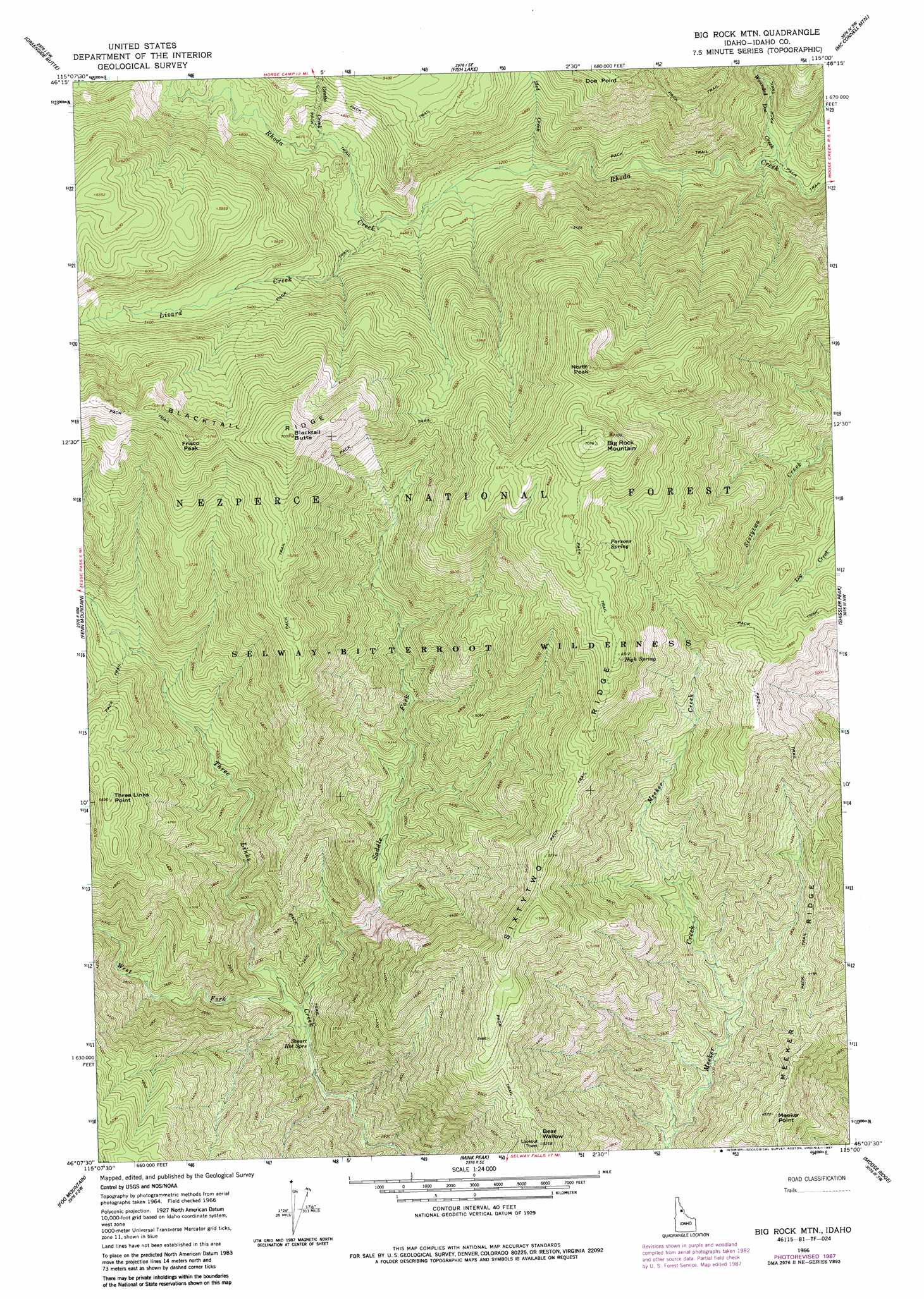
USGS Topo Quad 46115b1 - 1:24,000 scale
| Topo Map Name: | Big Rock Mountain |
| USGS Topo Quad ID: | 46115b1 |
| Print Size: | ca. 21 1/4" wide x 27" high |
| Southeast Coordinates: | 46.125° N latitude / 115° W longitude |
| Map Center Coordinates: | 46.1875° N latitude / 115.0625° W longitude |
| U.S. State: | ID |
| Filename: | o46115b1.jpg |
| Download Map JPG Image: | Big Rock Mountain topo map 1:24,000 scale |
| Map Type: | Topographic |
| Topo Series: | 7.5´ |
| Map Scale: | 1:24,000 |
| Source of Map Images: | United States Geological Survey (USGS) |
| Alternate Map Versions: |
Big Rock Mtn ID 1966, updated 1968 Download PDF Buy paper map Big Rock Mtn ID 1966, updated 1978 Download PDF Buy paper map Big Rock Mtn ID 1966, updated 1987 Download PDF Buy paper map Big Rock Mountain ID 1995, updated 1999 Download PDF Buy paper map Big Rock Mountain ID 2011 Download PDF Buy paper map Big Rock Mountain ID 2013 Download PDF Buy paper map |
| FStopo: | US Forest Service topo Big Rock Mountain is available: Download FStopo PDF Download FStopo TIF |
1:24,000 Topo Quads surrounding Big Rock Mountain
Liz Butte |
Holly Creek |
Greystone Butte |
Bear Mountain |
Tom Beal Peak |
Huckleberry Butte |
Greenside Butte |
Fish Lake |
Mcconnell Mountain |
Hungry Rock |
Chimney Peak |
Fenn Mountain |
Big Rock Mountain |
Shissler Peak |
Freeman Peak |
Selway Falls |
Fog Mountain |
Mink Peak |
Moose Ridge |
Dog Creek |
Anderson Butte |
Vermilion Peak |
Running Lake |
Wylies Peak |
Gardiner Peak |
> Back to 46115a1 at 1:100,000 scale
> Back to 46114a1 at 1:250,000 scale
> Back to U.S. Topo Maps home
Big Rock Mountain topo map: Gazetteer
Big Rock Mountain: Cliffs
Meeker Point elevation 1395m 4576′Three Links Point elevation 1686m 5531′
Big Rock Mountain: Ridges
Blacktail Ridge elevation 1991m 6532′Meeker Ridge elevation 1272m 4173′
Sixtytwo Ridge elevation 1732m 5682′
Big Rock Mountain: Springs
High Spring elevation 1981m 6499′Parsons Spring elevation 1970m 6463′
Stuart Hot Springs elevation 872m 2860′
Big Rock Mountain: Streams
Grotto Creek elevation 1376m 4514′Lizard Creek elevation 1333m 4373′
Saddle Fork elevation 889m 2916′
Sled Creek elevation 1256m 4120′
West Fork Three Links Creek elevation 899m 2949′
Wounded Doe Creek elevation 1098m 3602′
Big Rock Mountain: Summits
Bear Wallow elevation 1601m 5252′Big Rock Mountain elevation 2151m 7057′
Blacktail Butte elevation 2136m 7007′
Frisco Peak elevation 2079m 6820′
North Peak elevation 2116m 6942′
Big Rock Mountain digital topo map on disk
Buy this Big Rock Mountain topo map showing relief, roads, GPS coordinates and other geographical features, as a high-resolution digital map file on DVD: