Liz Butte Topo Map Idaho
To zoom in, hover over the map of Liz Butte
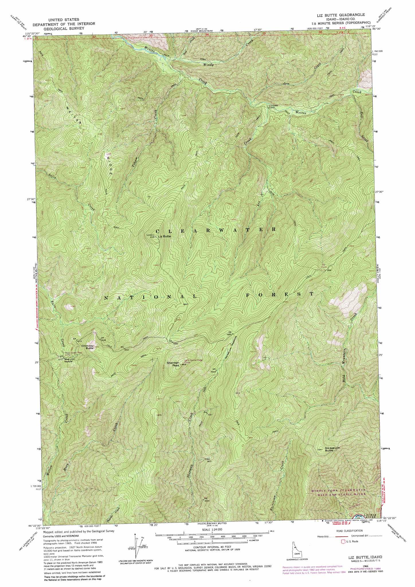
USGS Topo Quad 46115d3 - 1:24,000 scale
| Topo Map Name: | Liz Butte |
| USGS Topo Quad ID: | 46115d3 |
| Print Size: | ca. 21 1/4" wide x 27" high |
| Southeast Coordinates: | 46.375° N latitude / 115.25° W longitude |
| Map Center Coordinates: | 46.4375° N latitude / 115.3125° W longitude |
| U.S. State: | ID |
| Filename: | o46115d3.jpg |
| Download Map JPG Image: | Liz Butte topo map 1:24,000 scale |
| Map Type: | Topographic |
| Topo Series: | 7.5´ |
| Map Scale: | 1:24,000 |
| Source of Map Images: | United States Geological Survey (USGS) |
| Alternate Map Versions: |
Liz Butte ID 1966, updated 1969 Download PDF Buy paper map Liz Butte ID 1966, updated 1984 Download PDF Buy paper map Liz Butte ID 1994, updated 1997 Download PDF Buy paper map Liz Butte ID 2011 Download PDF Buy paper map Liz Butte ID 2013 Download PDF Buy paper map |
| FStopo: | US Forest Service topo Liz Butte is available: Download FStopo PDF Download FStopo TIF |
1:24,000 Topo Quads surrounding Liz Butte
Clarke Mountain |
Pot Mountain |
Junction Mountain |
Scurvy Mountain |
Gorman Hill |
Larch Butte |
Lean-To Point |
Cook Mountain |
Lookout Peak |
Horseshoe Lake |
Snowy Summit |
Weitas Butte |
Liz Butte |
Holly Creek |
Greystone Butte |
Boundary Peak |
Mclendon Butte |
Huckleberry Butte |
Greenside Butte |
Fish Lake |
Lowell |
Coolwater Mountain |
Chimney Peak |
Fenn Mountain |
Big Rock Mountain |
> Back to 46115a1 at 1:100,000 scale
> Back to 46114a1 at 1:250,000 scale
> Back to U.S. Topo Maps home
Liz Butte topo map: Gazetteer
Liz Butte: Bridges
Upper Weitas Pack Bridge elevation 986m 3234′Liz Butte: Flats
No-see-um Meadows elevation 1793m 5882′Liz Butte: Gaps
Sherman Saddle elevation 1441m 4727′Liz Butte: Ridges
Weitas Ridge elevation 1578m 5177′Liz Butte: Streams
Ball Creek elevation 1126m 3694′Jam Creek elevation 1046m 3431′
Liz Creek elevation 1057m 3467′
Seat Creek elevation 995m 3264′
Windy Creek elevation 983m 3225′
Yokum Creek elevation 995m 3264′
Liz Butte: Summits
Chimney Butte elevation 1710m 5610′Liz Butte elevation 1857m 6092′
No-see-um Butte elevation 1701m 5580′
Sherman Peak elevation 2029m 6656′
Liz Butte digital topo map on disk
Buy this Liz Butte topo map showing relief, roads, GPS coordinates and other geographical features, as a high-resolution digital map file on DVD: