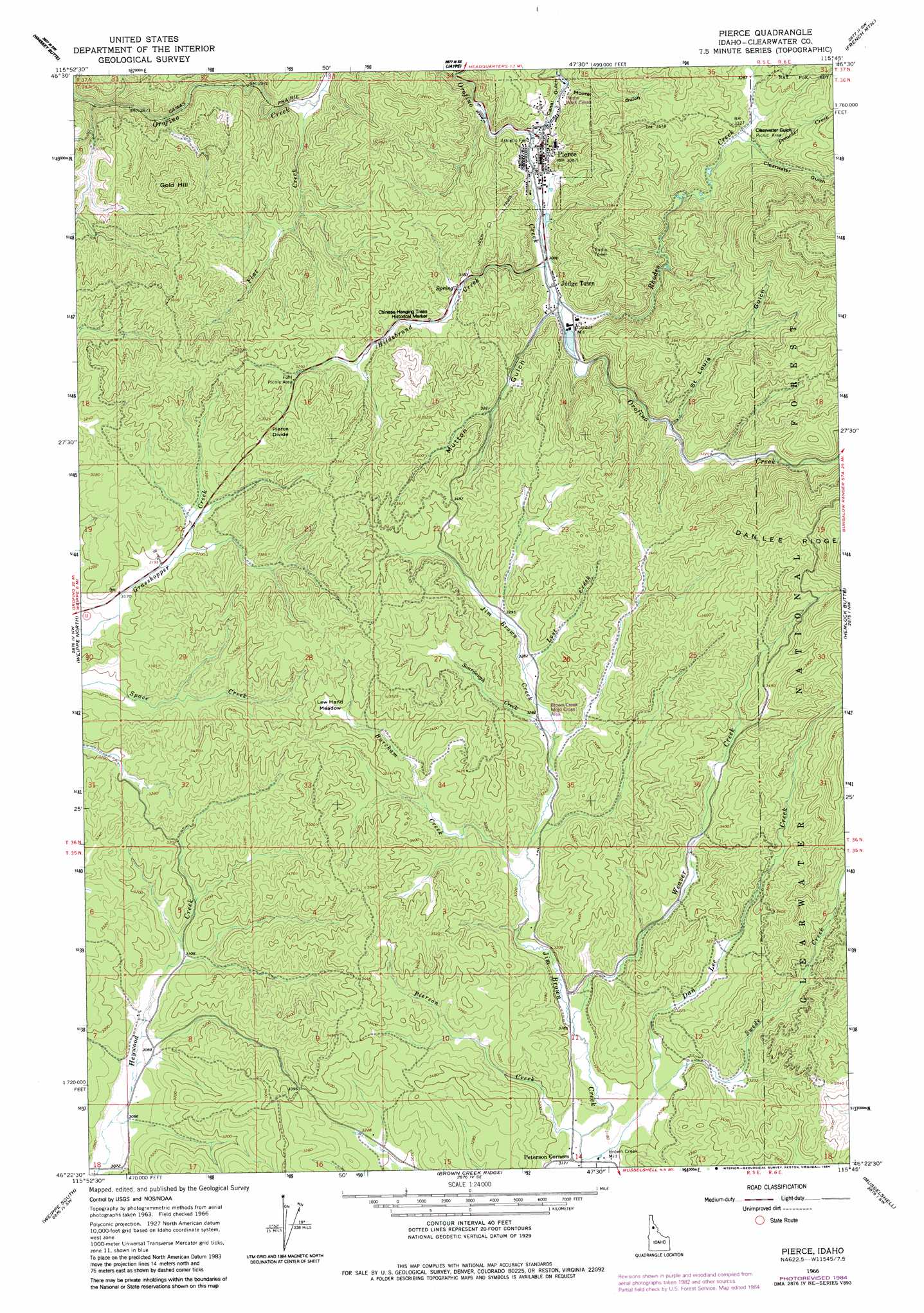
Pierce Topo Map Idaho
To zoom in, hover over the map of Pierce
USGS Topo Quad 46115d7 - 1:24,000 scale
| Topo Map Name: | Pierce |
| USGS Topo Quad ID: | 46115d7 |
| Print Size: | ca. 21 1/4" wide x 27" high |
| Southeast Coordinates: | 46.375° N latitude / 115.75° W longitude |
| Map Center Coordinates: | 46.4375° N latitude / 115.8125° W longitude |
| U.S. State: | ID |
| Filename: | o46115d7.jpg |
| Download Map JPG Image: | Pierce topo map 1:24,000 scale |
| Map Type: | Topographic |
| Topo Series: | 7.5´ |
| Map Scale: | 1:24,000 |
| Source of Map Images: | United States Geological Survey (USGS) |
| Alternate Map Versions: |
Pierce ID 1966, updated 1968 Download PDF Buy paper map Pierce ID 1966, updated 1984 Download PDF Buy paper map Pierce ID 1994, updated 1997 Download PDF Buy paper map Pierce ID 2011 Download PDF Buy paper map Pierce ID 2013 Download PDF Buy paper map |
| FStopo: | US Forest Service topo Pierce is available: Download FStopo PDF Download FStopo TIF |
1:24,000 Topo Quads surrounding Pierce
Little Green Mountain |
John Lewis Mountain |
Headquarters |
Browns Rock |
Clarke Mountain |
Grangemont |
Whiskey Butte |
Jaype |
French Mountain |
Larch Butte |
Rudo |
Weippe North |
Pierce |
Hemlock Butte |
Snowy Summit |
Woodland |
Weippe South |
Brown Creek Ridge |
Musselshell |
Boundary Peak |
Kamiah |
Kooskia |
Glenwood |
Syringa |
Lowell |
> Back to 46115a1 at 1:100,000 scale
> Back to 46114a1 at 1:250,000 scale
> Back to U.S. Topo Maps home
Pierce topo map: Gazetteer
Pierce: Flats
Gold Dollar Flat elevation 1093m 3585′Lew Hand Meadow elevation 1024m 3359′
Pierce: Gaps
Pierce Divide elevation 1059m 3474′Pierce: Parks
Hanging Trees Historical Marker elevation 987m 3238′Pierce: Populated Places
Cardiff Mill elevation 947m 3106′Judge Town elevation 945m 3100′
Oro Fino (historical) elevation 946m 3103′
Pierce elevation 943m 3093′
Pierce: Streams
Bat Creek elevation 966m 3169′Burcham Creek elevation 982m 3221′
Canal Gulch Creek elevation 933m 3061′
Dan Lee Creek elevation 971m 3185′
Flat Creek elevation 903m 2962′
Hildebrand Creek elevation 941m 3087′
Lost Creek elevation 1000m 3280′
Pierson Creek elevation 964m 3162′
Preacher Creek elevation 995m 3264′
Quartz Creek elevation 932m 3057′
Rhodes Creek elevation 944m 3097′
Sourdough Creek elevation 989m 3244′
Swede Creek elevation 964m 3162′
Weaver Creek elevation 971m 3185′
Pierce: Summits
Gold Hill elevation 1123m 3684′Pierce: Valleys
Canal Gulch elevation 943m 3093′Clearwater Gulch elevation 1003m 3290′
Moore Gulch elevation 951m 3120′
Mutton Gulch elevation 947m 3106′
Saint Louis Gulch elevation 980m 3215′
Pierce digital topo map on disk
Buy this Pierce topo map showing relief, roads, GPS coordinates and other geographical features, as a high-resolution digital map file on DVD: