Horseshoe Lake Topo Map Idaho
To zoom in, hover over the map of Horseshoe Lake
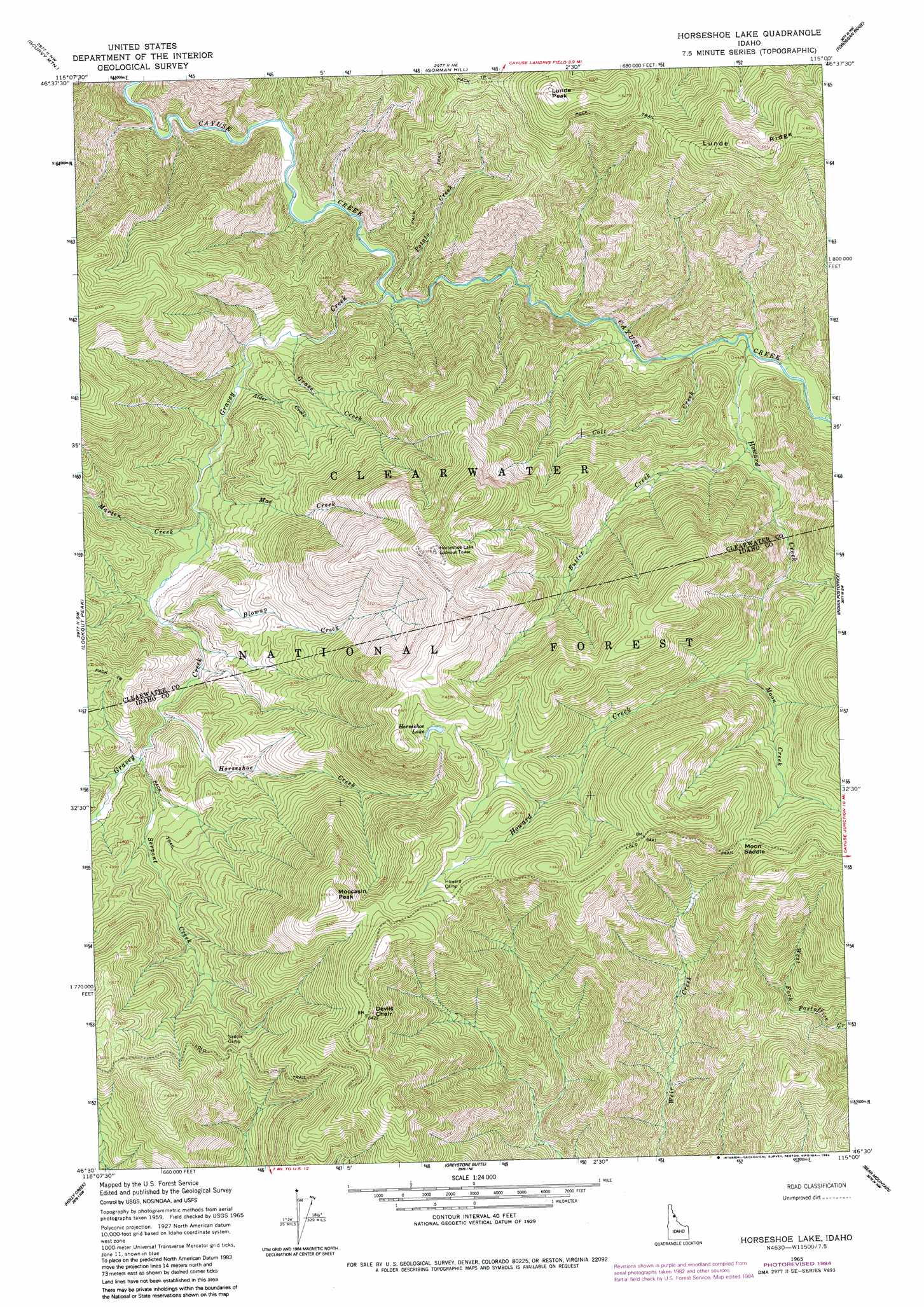
USGS Topo Quad 46115e1 - 1:24,000 scale
| Topo Map Name: | Horseshoe Lake |
| USGS Topo Quad ID: | 46115e1 |
| Print Size: | ca. 21 1/4" wide x 27" high |
| Southeast Coordinates: | 46.5° N latitude / 115° W longitude |
| Map Center Coordinates: | 46.5625° N latitude / 115.0625° W longitude |
| U.S. State: | ID |
| Filename: | o46115e1.jpg |
| Download Map JPG Image: | Horseshoe Lake topo map 1:24,000 scale |
| Map Type: | Topographic |
| Topo Series: | 7.5´ |
| Map Scale: | 1:24,000 |
| Source of Map Images: | United States Geological Survey (USGS) |
| Alternate Map Versions: |
Horseshoe Lake ID 1965, updated 1967 Download PDF Buy paper map Horseshoe Lake ID 1965, updated 1984 Download PDF Buy paper map Horseshoe Lake ID 1994, updated 1998 Download PDF Buy paper map Horseshoe Lake ID 2011 Download PDF Buy paper map Horseshoe Lake ID 2013 Download PDF Buy paper map |
| FStopo: | US Forest Service topo Horseshoe Lake is available: Download FStopo PDF Download FStopo TIF |
1:24,000 Topo Quads surrounding Horseshoe Lake
Elizabeth Lake |
Moose Mountain |
Osier Ridge |
Bruin Hill |
Schley Mountain |
Junction Mountain |
Scurvy Mountain |
Gorman Hill |
Toboggan Ridge |
Rhodes Peak |
Cook Mountain |
Lookout Peak |
Horseshoe Lake |
Indian Postoffice |
Cayuse Junction |
Liz Butte |
Holly Creek |
Greystone Butte |
Bear Mountain |
Tom Beal Peak |
Huckleberry Butte |
Greenside Butte |
Fish Lake |
Mcconnell Mountain |
Hungry Rock |
> Back to 46115e1 at 1:100,000 scale
> Back to 46114a1 at 1:250,000 scale
> Back to U.S. Topo Maps home
Horseshoe Lake topo map: Gazetteer
Horseshoe Lake: Forests
Clearwater National Forest elevation 1428m 4685′Horseshoe Lake: Gaps
Moon Saddle elevation 1860m 6102′Horseshoe Lake: Lakes
Horseshoe Lake elevation 1913m 6276′Horseshoe Lake: Pillars
Devils Chair elevation 1948m 6391′Horseshoe Lake: Streams
Alder Creek elevation 1249m 4097′Blowup Creek elevation 1322m 4337′
Butter Creek elevation 1336m 4383′
Colt Creek elevation 1264m 4146′
False Creek elevation 1264m 4146′
Grass Creek elevation 1222m 4009′
Gravey Creek elevation 1195m 3920′
Horseshoe Creek elevation 1365m 4478′
Howard Creek elevation 1276m 4186′
Mae Creek elevation 1279m 4196′
Marten Creek elevation 1290m 4232′
Moon Creek elevation 1595m 5232′
Potato Creek elevation 1199m 3933′
Serpent Creek elevation 1382m 4534′
Horseshoe Lake: Summits
Lunde Peak elevation 1938m 6358′Moccasin Peak elevation 2058m 6751′
Horseshoe Lake digital topo map on disk
Buy this Horseshoe Lake topo map showing relief, roads, GPS coordinates and other geographical features, as a high-resolution digital map file on DVD: