Moose Mountain Topo Map Idaho
To zoom in, hover over the map of Moose Mountain
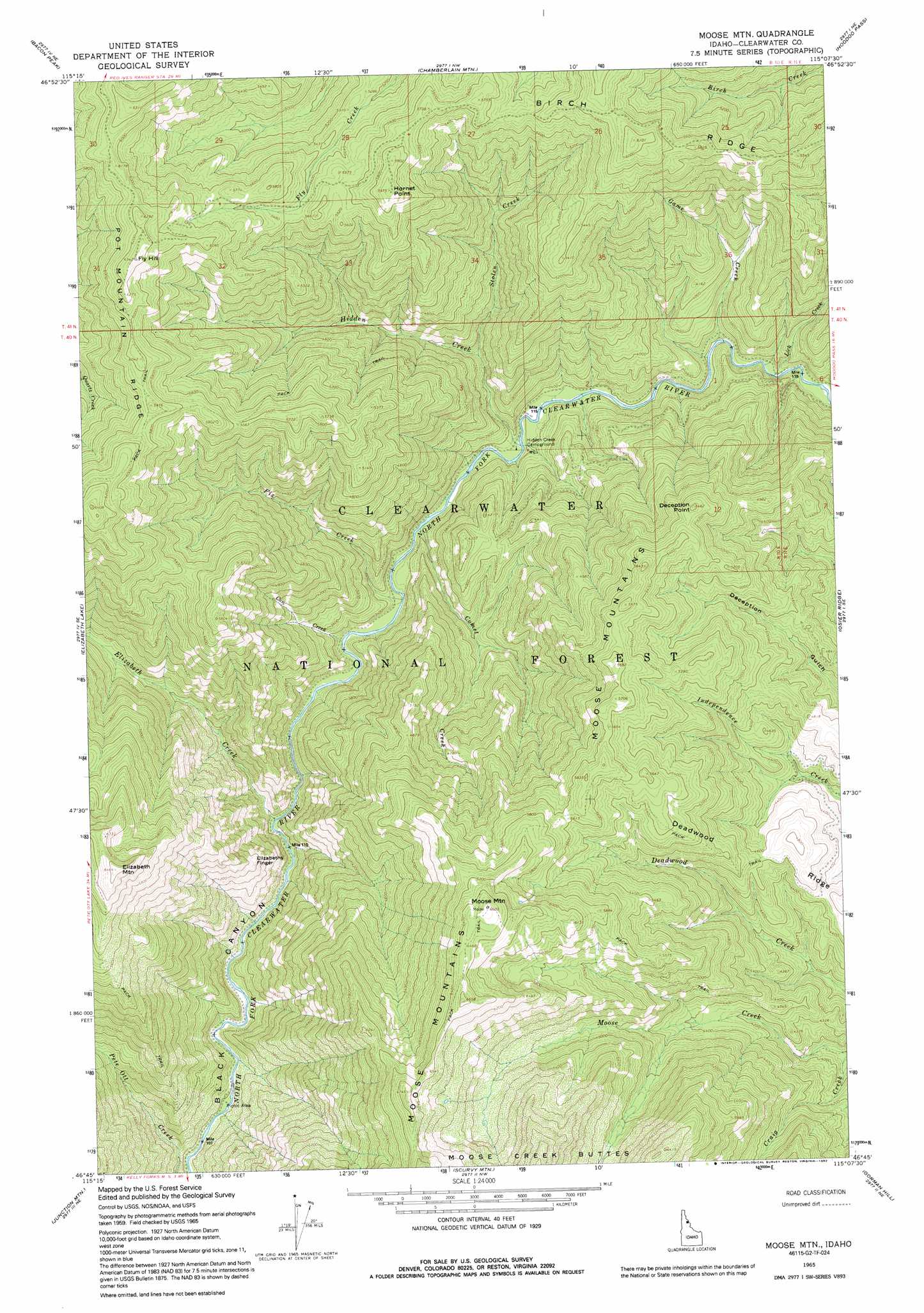
USGS Topo Quad 46115g2 - 1:24,000 scale
| Topo Map Name: | Moose Mountain |
| USGS Topo Quad ID: | 46115g2 |
| Print Size: | ca. 21 1/4" wide x 27" high |
| Southeast Coordinates: | 46.75° N latitude / 115.125° W longitude |
| Map Center Coordinates: | 46.8125° N latitude / 115.1875° W longitude |
| U.S. State: | ID |
| Filename: | o46115g2.jpg |
| Download Map JPG Image: | Moose Mountain topo map 1:24,000 scale |
| Map Type: | Topographic |
| Topo Series: | 7.5´ |
| Map Scale: | 1:24,000 |
| Source of Map Images: | United States Geological Survey (USGS) |
| Alternate Map Versions: |
Moose Mtn ID 1965, updated 1967 Download PDF Buy paper map Moose Mtn ID 1965, updated 1992 Download PDF Buy paper map Moose Mountain ID 1994, updated 1997 Download PDF Buy paper map Moose Mountain ID 2011 Download PDF Buy paper map Moose Mountain ID 2013 Download PDF Buy paper map |
| FStopo: | US Forest Service topo Moose Mountain is available: Download FStopo PDF Download FStopo TIF |
1:24,000 Topo Quads surrounding Moose Mountain
Peggy Peak |
Red Ives Peak |
Sherlock Peak |
Illinois Peak |
Landowner Mountain |
Pole Mountain |
Bacon Peak |
Chamberlain Mountain |
Hoodoo Pass |
Straight Peak |
The Nub |
Elizabeth Lake |
Moose Mountain |
Osier Ridge |
Bruin Hill |
Pot Mountain |
Junction Mountain |
Scurvy Mountain |
Gorman Hill |
Toboggan Ridge |
Lean-To Point |
Cook Mountain |
Lookout Peak |
Horseshoe Lake |
Indian Postoffice |
> Back to 46115e1 at 1:100,000 scale
> Back to 46114a1 at 1:250,000 scale
> Back to U.S. Topo Maps home
Moose Mountain topo map: Gazetteer
Moose Mountain: Pillars
Elizabeths Finger elevation 1330m 4363′Moose Mountain: Ranges
Moose Mountains elevation 2053m 6735′Moose Mountain: Ridges
Birch Ridge elevation 1842m 6043′Deadwood Ridge elevation 1466m 4809′
Moose Mountain: Streams
Can Creek elevation 1003m 3290′Comet Creek elevation 1010m 3313′
Craig Creek elevation 1175m 3854′
Elizabeth Creek elevation 973m 3192′
Fix Creek elevation 1005m 3297′
Game Creek elevation 1038m 3405′
Hidden Creek elevation 1022m 3353′
Lick Creek elevation 1051m 3448′
Stolen Creek elevation 1126m 3694′
Moose Mountain: Summits
Deception Point elevation 1628m 5341′Elizabeth Mountain elevation 1965m 6446′
Fly Hill elevation 1928m 6325′
Hornet Point elevation 1797m 5895′
Moose Mountain elevation 2006m 6581′
Moose Mountain digital topo map on disk
Buy this Moose Mountain topo map showing relief, roads, GPS coordinates and other geographical features, as a high-resolution digital map file on DVD: