Elizabeth Lake Topo Map Idaho
To zoom in, hover over the map of Elizabeth Lake
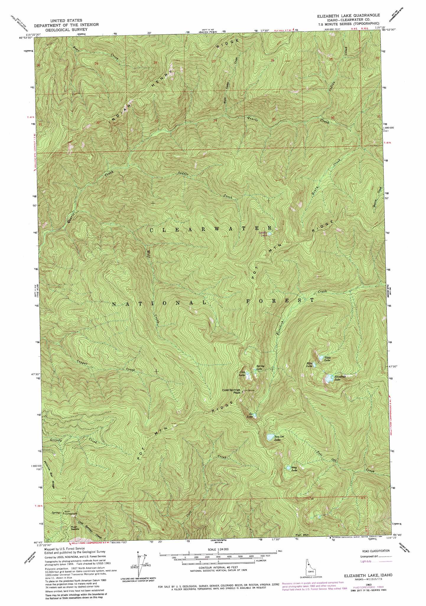
USGS Topo Quad 46115g3 - 1:24,000 scale
| Topo Map Name: | Elizabeth Lake |
| USGS Topo Quad ID: | 46115g3 |
| Print Size: | ca. 21 1/4" wide x 27" high |
| Southeast Coordinates: | 46.75° N latitude / 115.25° W longitude |
| Map Center Coordinates: | 46.8125° N latitude / 115.3125° W longitude |
| U.S. State: | ID |
| Filename: | o46115g3.jpg |
| Download Map JPG Image: | Elizabeth Lake topo map 1:24,000 scale |
| Map Type: | Topographic |
| Topo Series: | 7.5´ |
| Map Scale: | 1:24,000 |
| Source of Map Images: | United States Geological Survey (USGS) |
| Alternate Map Versions: |
Elizabeth Lake ID 1963, updated 1964 Download PDF Buy paper map Elizabeth Lake ID 1963, updated 1984 Download PDF Buy paper map Elizabeth Lake ID 1994, updated 1997 Download PDF Buy paper map Elizabeth Lake ID 2011 Download PDF Buy paper map Elizabeth Lake ID 2013 Download PDF Buy paper map |
| FStopo: | US Forest Service topo Elizabeth Lake is available: Download FStopo PDF Download FStopo TIF |
1:24,000 Topo Quads surrounding Elizabeth Lake
Bathtub Mountain |
Peggy Peak |
Red Ives Peak |
Sherlock Peak |
Illinois Peak |
Mallard Peak |
Pole Mountain |
Bacon Peak |
Chamberlain Mountain |
Hoodoo Pass |
Sheep Mountain |
The Nub |
Elizabeth Lake |
Moose Mountain |
Osier Ridge |
Clarke Mountain |
Pot Mountain |
Junction Mountain |
Scurvy Mountain |
Gorman Hill |
Larch Butte |
Lean-To Point |
Cook Mountain |
Lookout Peak |
Horseshoe Lake |
> Back to 46115e1 at 1:100,000 scale
> Back to 46114a1 at 1:250,000 scale
> Back to U.S. Topo Maps home
Elizabeth Lake topo map: Gazetteer
Elizabeth Lake: Gaps
Mush Saddle elevation 1637m 5370′Elizabeth Lake: Lakes
Cold Lake elevation 1861m 6105′Elizabeth Lake elevation 1812m 5944′
Ellie Lake elevation 1889m 6197′
Ice Lake elevation 1788m 5866′
Pete Ott Lake elevation 1738m 5702′
Ring Lake elevation 1703m 5587′
Spring Lake elevation 1792m 5879′
Tille Lake elevation 1752m 5748′
Elizabeth Lake: Ridges
Indian Henry Ridge elevation 1640m 5380′Pot Mountain Ridge elevation 1968m 6456′
Elizabeth Lake: Streams
Henry Creek elevation 1377m 4517′Indian Creek elevation 1268m 4160′
Saddle Creek elevation 936m 3070′
Twin Cabin Creek elevation 1108m 3635′
Wolf Creek elevation 840m 2755′
Elizabeth Lake: Summits
Cold Springs Peak elevation 2041m 6696′Elizabeth Lake digital topo map on disk
Buy this Elizabeth Lake topo map showing relief, roads, GPS coordinates and other geographical features, as a high-resolution digital map file on DVD: