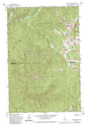
Bacon Peak Topo Map Idaho
To zoom in, hover over the map of Bacon Peak
USGS Topo Quad 46115h3 - 1:24,000 scale
| Topo Map Name: | Bacon Peak |
| USGS Topo Quad ID: | 46115h3 |
| Print Size: | ca. 21 1/4" wide x 27" high |
| Southeast Coordinates: | 46.875° N latitude / 115.25° W longitude |
| Map Center Coordinates: | 46.9375° N latitude / 115.3125° W longitude |
| U.S. State: | ID |
| Filename: | o46115h3.jpg |
| Download Map JPG Image: | Bacon Peak topo map 1:24,000 scale |
| Map Type: | Topographic |
| Topo Series: | 7.5´ |
| Map Scale: | 1:24,000 |
| Source of Map Images: | United States Geological Survey (USGS) |
| Alternate Map Versions: |
Bacon Peak ID 1963, updated 1964 Download PDF Buy paper map Bacon Peak ID 1963, updated 1975 Download PDF Buy paper map Bacon Peak ID 1963, updated 1984 Download PDF Buy paper map Bacon Peak ID 1963, updated 1986 Download PDF Buy paper map Bacon Peak ID 1994, updated 1997 Download PDF Buy paper map Bacon Peak ID 2011 Download PDF Buy paper map Bacon Peak ID 2014 Download PDF Buy paper map |
| FStopo: | US Forest Service topo Bacon Peak is available: Download FStopo PDF Download FStopo TIF |
1:24,000 Topo Quads surrounding Bacon Peak
> Back to 46115e1 at 1:100,000 scale
> Back to 46114a1 at 1:250,000 scale
> Back to U.S. Topo Maps home
Bacon Peak topo map: Gazetteer
Bacon Peak: Lakes
Bacon Lake elevation 1787m 5862′Berel Lake elevation 1790m 5872′
Copper Lake elevation 1753m 5751′
Forage Lake elevation 1752m 5748′
Gold Lake elevation 1863m 6112′
Halo Lake elevation 1872m 6141′
Heather Lake elevation 1877m 6158′
Platinum Lake elevation 1752m 5748′
Seed lake elevation 1911m 6269′
Silver Lake elevation 1801m 5908′
Tin lake elevation 1755m 5757′
Bacon Peak: Streams
Bacon Creek elevation 1245m 4084′Barren Creek elevation 1079m 3540′
Basin Creek elevation 1343m 4406′
Bean Creek elevation 850m 2788′
Bear Creek elevation 846m 2775′
Copper Creek elevation 1030m 3379′
Frost Creek elevation 971m 3185′
Pass Creek elevation 1262m 4140′
Pole Creek elevation 1222m 4009′
Roaring Creek elevation 918m 3011′
Ruby Creek elevation 1209m 3966′
Snow Creek elevation 843m 2765′
Bacon Peak: Summits
Bacon Peak elevation 1924m 6312′Five Lakes Butte elevation 2035m 6676′
Ruby Point elevation 1780m 5839′
Bacon Peak digital topo map on disk
Buy this Bacon Peak topo map showing relief, roads, GPS coordinates and other geographical features, as a high-resolution digital map file on DVD:


