Pinchot Butte Topo Map Idaho
To zoom in, hover over the map of Pinchot Butte
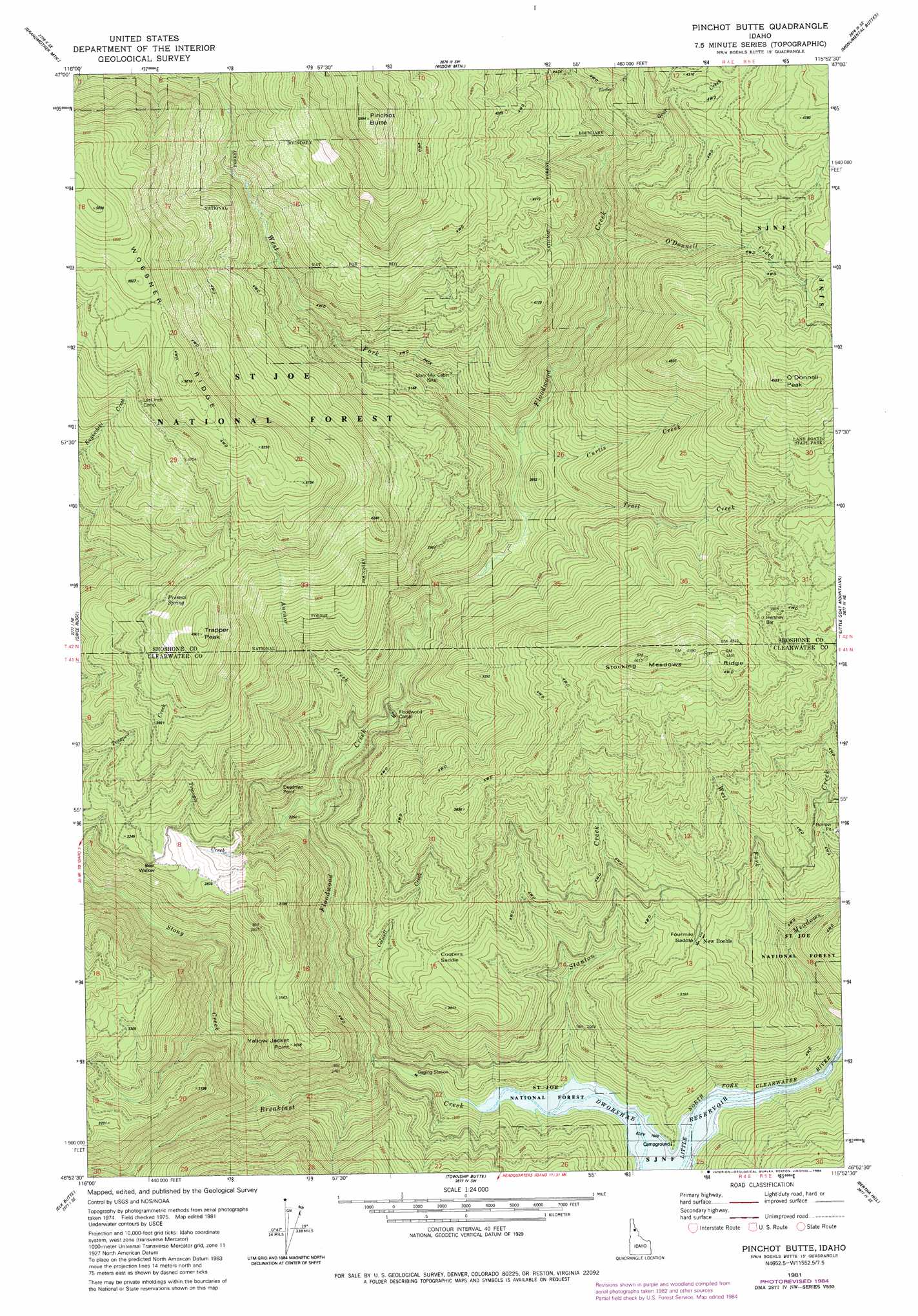
USGS Topo Quad 46115h8 - 1:24,000 scale
| Topo Map Name: | Pinchot Butte |
| USGS Topo Quad ID: | 46115h8 |
| Print Size: | ca. 21 1/4" wide x 27" high |
| Southeast Coordinates: | 46.875° N latitude / 115.875° W longitude |
| Map Center Coordinates: | 46.9375° N latitude / 115.9375° W longitude |
| U.S. State: | ID |
| Filename: | o46115h8.jpg |
| Download Map JPG Image: | Pinchot Butte topo map 1:24,000 scale |
| Map Type: | Topographic |
| Topo Series: | 7.5´ |
| Map Scale: | 1:24,000 |
| Source of Map Images: | United States Geological Survey (USGS) |
| Alternate Map Versions: |
Pinchot Butte ID 1981, updated 1982 Download PDF Buy paper map Pinchot Butte ID 1981, updated 1984 Download PDF Buy paper map Pinchot Butte ID 1994, updated 1997 Download PDF Buy paper map Pinchot Butte ID 2011 Download PDF Buy paper map Pinchot Butte ID 2013 Download PDF Buy paper map |
| FStopo: | US Forest Service topo Pinchot Butte is available: Download FStopo PDF Download FStopo TIF |
1:24,000 Topo Quads surrounding Pinchot Butte
Huckleberry Mountain |
Marble Mountain |
Hoyt Mountain |
Fishhook Creek |
Three Sisters |
Merry Creek |
Grandmother Mountain |
Widow Mountain |
Monumental Buttes |
Montana Peak |
Anthony Peak |
Grice Ridge |
Pinchot Butte |
Little Goat Mountains |
Buzzard Roost |
Elk River |
Elk Butte |
Township Butte |
Bertha Hill |
Thompson Point |
Elk Creek Falls |
Little Green Mountain |
John Lewis Mountain |
Headquarters |
Browns Rock |
> Back to 46115e1 at 1:100,000 scale
> Back to 46114a1 at 1:250,000 scale
> Back to U.S. Topo Maps home
Pinchot Butte topo map: Gazetteer
Pinchot Butte: Forests
Floodwood State Forest elevation 1338m 4389′Pinchot Butte: Gaps
Coopers Saddle elevation 848m 2782′Pinchot Butte: Streams
Floodwood Creek elevation 521m 1709′Goat Creek elevation 939m 3080′
Meadows Creek elevation 493m 1617′
O'Donnell Creek elevation 897m 2942′
Stanton Creek elevation 489m 1604′
Stony Creek elevation 561m 1840′
Timber Creek elevation 991m 3251′
Trail Creek elevation 745m 2444′
West Fork Floodwood Creek elevation 765m 2509′
Pinchot Butte: Summits
Pinchot Butte elevation 1823m 5980′Pinchot Butte: Trails
Freezeout Trail elevation 1304m 4278′Pinchot Butte digital topo map on disk
Buy this Pinchot Butte topo map showing relief, roads, GPS coordinates and other geographical features, as a high-resolution digital map file on DVD: