Limekiln Rapids Topo Map Idaho
To zoom in, hover over the map of Limekiln Rapids
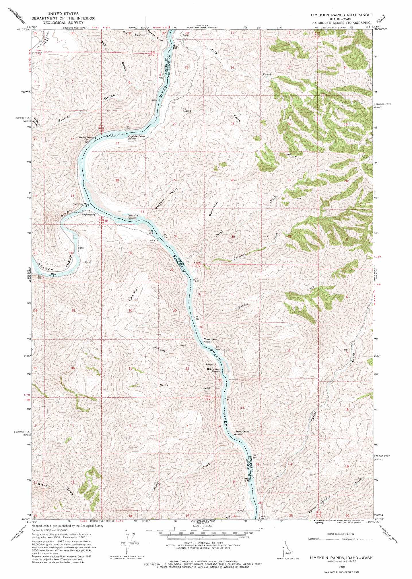
USGS Topo Quad 46116a8 - 1:24,000 scale
| Topo Map Name: | Limekiln Rapids |
| USGS Topo Quad ID: | 46116a8 |
| Print Size: | ca. 21 1/4" wide x 27" high |
| Southeast Coordinates: | 46° N latitude / 116.875° W longitude |
| Map Center Coordinates: | 46.0625° N latitude / 116.9375° W longitude |
| U.S. States: | ID, WA |
| Filename: | o46116a8.jpg |
| Download Map JPG Image: | Limekiln Rapids topo map 1:24,000 scale |
| Map Type: | Topographic |
| Topo Series: | 7.5´ |
| Map Scale: | 1:24,000 |
| Source of Map Images: | United States Geological Survey (USGS) |
| Alternate Map Versions: |
Limekiln Rapids ID 1968, updated 1971 Download PDF Buy paper map Limekiln Rapids ID 1968, updated 1980 Download PDF Buy paper map Limekiln Rapids ID 1968, updated 1980 Download PDF Buy paper map Limekiln Rapids ID 2011 Download PDF Buy paper map Limekiln Rapids ID 2013 Download PDF Buy paper map |
| FStopo: | US Forest Service topo Limekiln Rapids is available: Download FStopo PDF Download FStopo TIF |
1:24,000 Topo Quads surrounding Limekiln Rapids
Rockpile Creek |
Asotin |
Lewiston Orchards South |
Sweetwater |
Culdesac South |
Anatone |
Weissenfels Ridge |
Captain John Rapids |
Waha |
Winchester West |
Fields Spring |
Black Butte |
Limekiln Rapids |
Frye Point |
Hoover Point |
Paradise |
Teepee Butte |
Jim Creek Butte |
Wapshilla Creek |
Rattlesnake Ridge |
Table Mountain |
Billy Meadows |
Poison Point |
Deadhorse Ridge |
Cactus Mountain |
> Back to 46116a1 at 1:100,000 scale
> Back to 46116a1 at 1:250,000 scale
> Back to U.S. Topo Maps home
Limekiln Rapids topo map: Gazetteer
Limekiln Rapids: Bars
Bear Bar elevation 262m 859′Limekiln Rapids: Cliffs
Limestone Point elevation 492m 1614′Limekiln Rapids: Populated Places
Rogersburg elevation 258m 846′Zindel (historical) elevation 908m 2979′
Limekiln Rapids: Rapids
Captain Lewis Rapids elevation 246m 807′Captain Lewis Rapids elevation 246m 807′
Limekiln Rapids elevation 251m 823′
Negro Head Rapids elevation 255m 836′
Shovel Creek Rapids elevation 258m 846′
Wild Goose Rapids elevation 256m 839′
Wild Goose Rapids elevation 256m 839′
Limekiln Rapids: Streams
Anaconda Creek elevation 255m 836′Bear Creek elevation 261m 856′
Billy Creek elevation 247m 810′
Birch Creek elevation 257m 843′
Camp Creek elevation 246m 807′
Chimney Creek elevation 257m 843′
Corral Creek elevation 262m 859′
Dough Creek elevation 256m 839′
Grande Ronde River elevation 250m 820′
Middle Creek elevation 257m 843′
Shovel Creek elevation 258m 846′
Shovel Creek elevation 258m 846′
Limekiln Rapids: Summits
Gold Hill elevation 992m 3254′Lime Hill elevation 888m 2913′
Limekiln Rapids: Valleys
Bob Gulch elevation 346m 1135′Box Gulch elevation 359m 1177′
Fisher Gulch elevation 252m 826′
Lathrop Gulch elevation 583m 1912′
Perkins Gulch elevation 244m 800′
Limekiln Rapids digital topo map on disk
Buy this Limekiln Rapids topo map showing relief, roads, GPS coordinates and other geographical features, as a high-resolution digital map file on DVD: