Mountain View Topo Map Washington
To zoom in, hover over the map of Mountain View
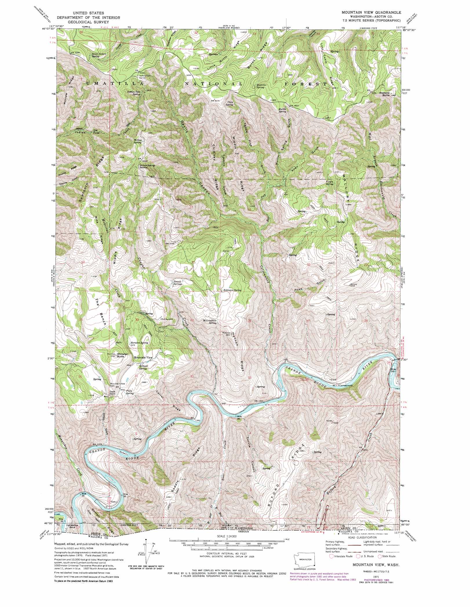
USGS Topo Quad 46117a3 - 1:24,000 scale
| Topo Map Name: | Mountain View |
| USGS Topo Quad ID: | 46117a3 |
| Print Size: | ca. 21 1/4" wide x 27" high |
| Southeast Coordinates: | 46° N latitude / 117.25° W longitude |
| Map Center Coordinates: | 46.0625° N latitude / 117.3125° W longitude |
| U.S. State: | WA |
| Filename: | o46117a3.jpg |
| Download Map JPG Image: | Mountain View topo map 1:24,000 scale |
| Map Type: | Topographic |
| Topo Series: | 7.5´ |
| Map Scale: | 1:24,000 |
| Source of Map Images: | United States Geological Survey (USGS) |
| Alternate Map Versions: |
Mountain View WA 1971, updated 1974 Download PDF Buy paper map Mountain View WA 1971, updated 1983 Download PDF Buy paper map Mountain View WA 1995, updated 1998 Download PDF Buy paper map Mountain View WA 2011 Download PDF Buy paper map Mountain View WA 2013 Download PDF Buy paper map |
| FStopo: | US Forest Service topo Mountain View is available: Download FStopo PDF Download FStopo TIF |
1:24,000 Topo Quads surrounding Mountain View
Rose Springs |
Peola |
Potter Hill |
Rockpile Creek |
Asotin |
Stentz Spring |
Pinkham Butte |
Harlow Ridge |
Anatone |
Weissenfels Ridge |
Diamond Peak |
Saddle Butte |
Mountain View |
Fields Spring |
Black Butte |
Eden |
Troy |
Flora |
Paradise |
Teepee Butte |
Promise |
Wood Butte |
Shamrock Creek |
Table Mountain |
Billy Meadows |
> Back to 46117a1 at 1:100,000 scale
> Back to 46116a1 at 1:250,000 scale
> Back to U.S. Topo Maps home
Mountain View topo map: Gazetteer
Mountain View: Capes
Cape Horn elevation 941m 3087′Mountain View: Gaps
Willow Spring Saddle elevation 1377m 4517′Mountain View: Islands
McNeill Island elevation 421m 1381′Mountain View: Populated Places
Hanson Ferry elevation 488m 1601′Mountain View elevation 905m 2969′
Mountain View: Ridges
Buford Ridge elevation 982m 3221′Burnt Ridge elevation 1453m 4767′
Chimney Ridge elevation 1106m 3628′
Corral Ridge elevation 684m 2244′
Hanson Ridge elevation 730m 2395′
Lost Cabin Ridge elevation 1419m 4655′
Mallory Ridge elevation 1180m 3871′
Middle Ridge elevation 1251m 4104′
Middle Ridge elevation 1201m 3940′
Mine Ridge elevation 1273m 4176′
Morrow Ridge elevation 1357m 4452′
Saddle Ridge elevation 968m 3175′
Sawtooth Ridge elevation 1327m 4353′
Short Ridge elevation 1141m 3743′
The Bench elevation 1147m 3763′
Mountain View: Springs
Crite Spring elevation 1382m 4534′Devils Slide elevation 1473m 4832′
Herndon Spring elevation 939m 3080′
Hostetler Spring elevation 1462m 4796′
Indian Tom Spring elevation 1438m 4717′
McLoughlin Spring elevation 879m 2883′
McMillan Spring elevation 1352m 4435′
McNeil Spring elevation 924m 3031′
Mullin Spring elevation 1466m 4809′
Plato Spring elevation 906m 2972′
Robinson Spring elevation 914m 2998′
Seven Sisters Spring elevation 1557m 5108′
Swank Springs elevation 956m 3136′
Virgin Spring elevation 1173m 3848′
Willow Spring elevation 1447m 4747′
Mountain View: Streams
Bear Creek elevation 403m 1322′Buford Creek elevation 378m 1240′
Buford Creek elevation 378m 1240′
Cottonwood Creek elevation 391m 1282′
Cougar Creek elevation 409m 1341′
East Bear Creek elevation 499m 1637′
East Bear Creek elevation 524m 1719′
East Fork Cottonwood Creek elevation 624m 2047′
Medicine Creek elevation 636m 2086′
Menatchee Creek elevation 438m 1437′
Rattlesnake Creek elevation 382m 1253′
West Bear Creek elevation 499m 1637′
West Bear Creek elevation 499m 1637′
Mountain View: Summits
Anatone Butte elevation 1491m 4891′Whitetail Butte elevation 1078m 3536′
Mountain View: Trails
Indian Tom Trail elevation 972m 3188′Mountain View: Valleys
Allen Gulch elevation 808m 2650′Coyote Canyon elevation 419m 1374′
Devils Canyon elevation 644m 2112′
Mullin Spring Gulch elevation 808m 2650′
Powe Gulch elevation 550m 1804′
Shittim Gulch elevation 421m 1381′
Smooth Gulch elevation 722m 2368′
Yellow Pine Gulch elevation 718m 2355′
Mountain View digital topo map on disk
Buy this Mountain View topo map showing relief, roads, GPS coordinates and other geographical features, as a high-resolution digital map file on DVD: