Eckler Mountain Topo Map Washington
To zoom in, hover over the map of Eckler Mountain
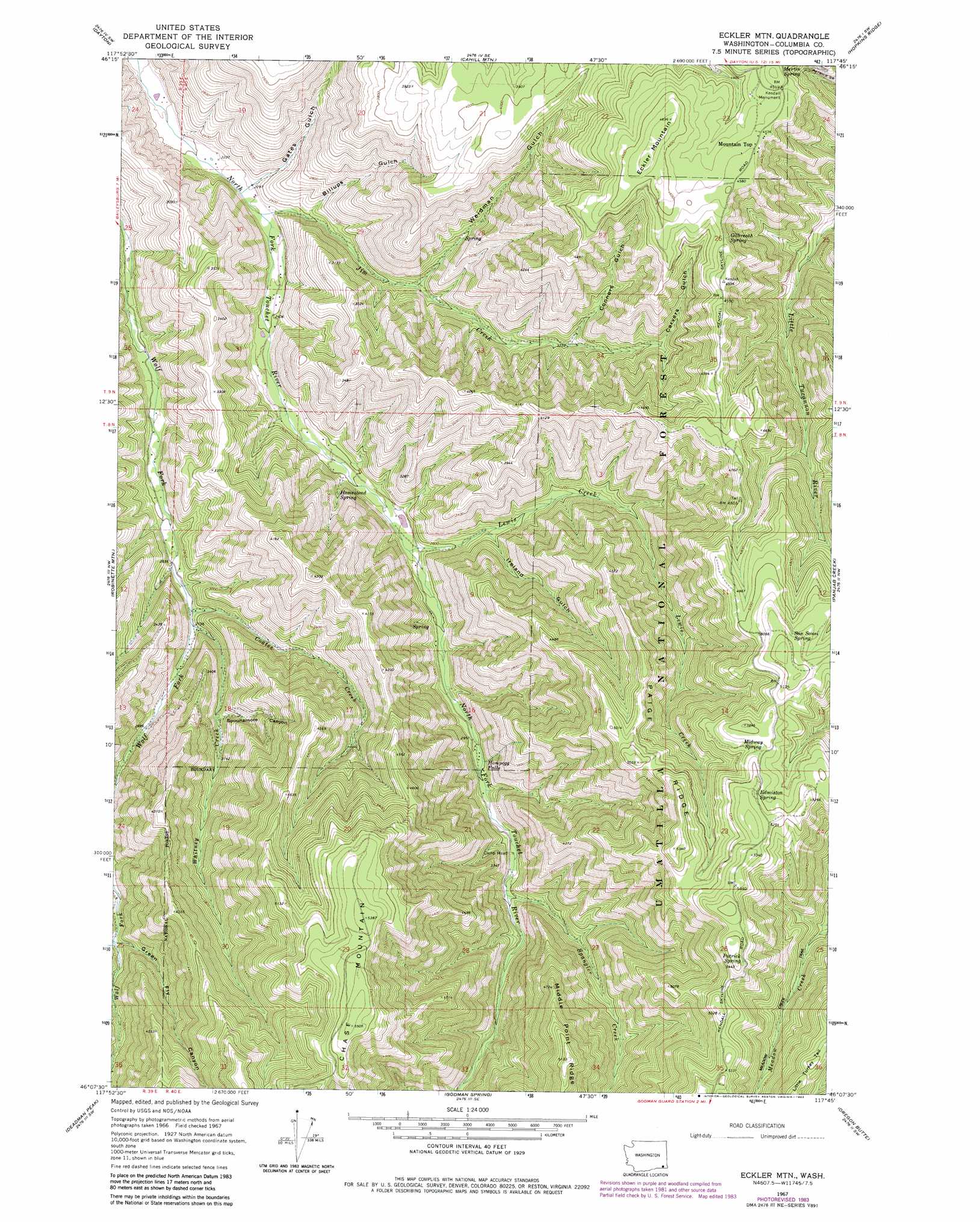
USGS Topo Quad 46117b7 - 1:24,000 scale
| Topo Map Name: | Eckler Mountain |
| USGS Topo Quad ID: | 46117b7 |
| Print Size: | ca. 21 1/4" wide x 27" high |
| Southeast Coordinates: | 46.125° N latitude / 117.75° W longitude |
| Map Center Coordinates: | 46.1875° N latitude / 117.8125° W longitude |
| U.S. State: | WA |
| Filename: | o46117b7.jpg |
| Download Map JPG Image: | Eckler Mountain topo map 1:24,000 scale |
| Map Type: | Topographic |
| Topo Series: | 7.5´ |
| Map Scale: | 1:24,000 |
| Source of Map Images: | United States Geological Survey (USGS) |
| Alternate Map Versions: |
Eckler Mtn WA 1967, updated 1971 Download PDF Buy paper map Eckler Mtn WA 1967, updated 1983 Download PDF Buy paper map Eckler Mountain WA 1995, updated 1998 Download PDF Buy paper map Eckler Mountain WA 2011 Download PDF Buy paper map Eckler Mountain WA 2014 Download PDF Buy paper map |
| FStopo: | US Forest Service topo Eckler Mountain is available: Download FStopo PDF Download FStopo TIF |
1:24,000 Topo Quads surrounding Eckler Mountain
Kellogg Creek |
Tucannon |
Turner |
Zumwalt |
Pomeroy |
Huntsville |
Dayton |
Cahill Mountain |
Hopkins Ridge |
Rose Springs |
Coppei |
Robinette Mountain |
Eckler Mountain |
Panjab Creek |
Stentz Spring |
Kooskooskie |
Deadman Peak |
Godman Spring |
Oregon Butte |
Diamond Peak |
Big Meadows |
Bone Spring |
Wenaha Forks |
Elbow Creek |
Eden |
> Back to 46117a1 at 1:100,000 scale
> Back to 46116a1 at 1:250,000 scale
> Back to U.S. Topo Maps home
Eckler Mountain topo map: Gazetteer
Eckler Mountain: Dams
Huckleberry Mountain Reservoir Dam elevation 820m 2690′Eckler Mountain: Falls
Hompegg Falls elevation 924m 3031′Eckler Mountain: Parks
Kendall Monument elevation 1378m 4520′Eckler Mountain: Populated Places
Mountain Top elevation 1382m 4534′Eckler Mountain: Ridges
Paige Ridge elevation 1626m 5334′Eckler Mountain: Springs
Edmiston Spring elevation 1598m 5242′Gilbreath Spring elevation 1354m 4442′
Homestead Spring elevation 854m 2801′
Martin Spring elevation 1293m 4242′
Midway Spring elevation 1567m 5141′
Patrick Spring elevation 1628m 5341′
San Sousi Spring elevation 1567m 5141′
Stockade Spring elevation 1349m 4425′
Eckler Mountain: Streams
Coates Creek elevation 830m 2723′Jim Creek elevation 698m 2290′
Lewis Creek elevation 824m 2703′
Spangler Creek elevation 971m 3185′
Whitney Creek elevation 838m 2749′
Eckler Mountain: Summits
Eckler Mountain elevation 1430m 4691′Eckler Mountain: Trails
Meadow Creek Trail elevation 1335m 4379′Eckler Mountain: Valleys
Billups Gulch elevation 732m 2401′Carvers Gulch elevation 1108m 3635′
Connors Gulch elevation 994m 3261′
Gates Gulch elevation 703m 2306′
Ireland Gulch elevation 906m 2972′
Spoonamore Canyon elevation 929m 3047′
Weidman Gulch elevation 822m 2696′
Eckler Mountain digital topo map on disk
Buy this Eckler Mountain topo map showing relief, roads, GPS coordinates and other geographical features, as a high-resolution digital map file on DVD: