College Place Topo Map Washington
To zoom in, hover over the map of College Place
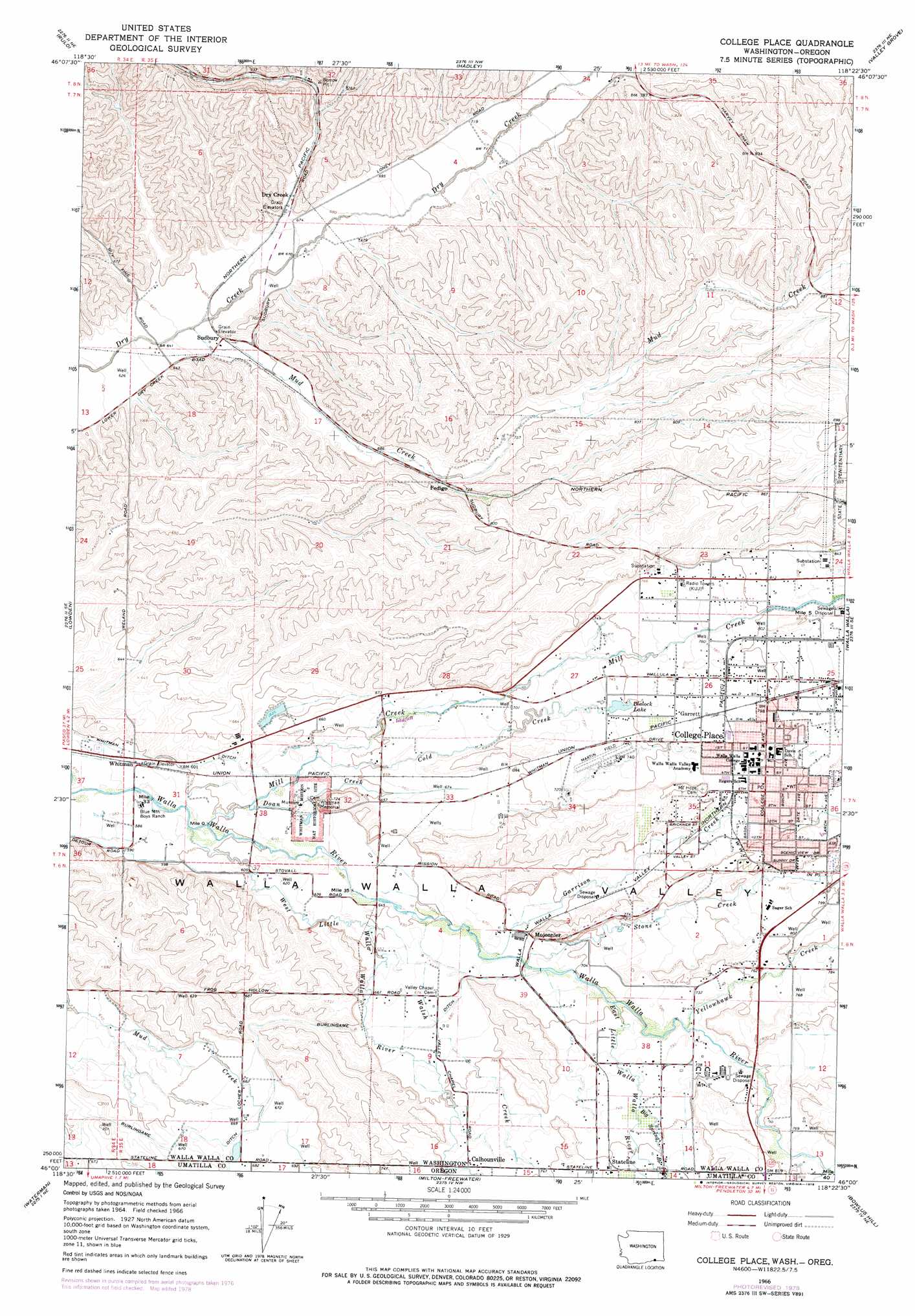
USGS Topo Quad 46118a4 - 1:24,000 scale
| Topo Map Name: | College Place |
| USGS Topo Quad ID: | 46118a4 |
| Print Size: | ca. 21 1/4" wide x 27" high |
| Southeast Coordinates: | 46° N latitude / 118.375° W longitude |
| Map Center Coordinates: | 46.0625° N latitude / 118.4375° W longitude |
| U.S. States: | WA, OR |
| Filename: | o46118a4.jpg |
| Download Map JPG Image: | College Place topo map 1:24,000 scale |
| Map Type: | Topographic |
| Topo Series: | 7.5´ |
| Map Scale: | 1:24,000 |
| Source of Map Images: | United States Geological Survey (USGS) |
| Alternate Map Versions: |
College Place WA 1966, updated 1968 Download PDF Buy paper map College Place WA 1966, updated 1978 Download PDF Buy paper map College Place WA 2011 Download PDF Buy paper map College Place WA 2013 Download PDF Buy paper map |
1:24,000 Topo Quads surrounding College Place
Page |
Eureka |
Harsha |
Prescott |
Waitsburg |
Welland |
Rulo |
Hadley |
Valley Grove |
Dixie |
Touchet |
Lowden |
College Place |
Walla Walla |
Buroker |
Smeltz |
Waterman |
Milton-Freewater |
Bowlus Hill |
Peterson Ridge |
Helix |
Adams |
Athena |
Weston Mountain |
Blalock Mountain |
> Back to 46118a1 at 1:100,000 scale
> Back to 46118a1 at 1:250,000 scale
> Back to U.S. Topo Maps home
College Place topo map: Gazetteer
College Place: Airports
Martin Field elevation 225m 738′College Place: Dams
Blalock Lake Dam elevation 226m 741′Stiller Dam elevation 196m 643′
College Place: Parks
Kiwanis Park elevation 246m 807′Lyons City Park elevation 247m 810′
Martin Field elevation 236m 774′
Whitman Memorial elevation 219m 718′
Whitman Mission National Historic Site elevation 190m 623′
College Place: Populated Places
Calhounville elevation 224m 734′College Place elevation 242m 793′
Dixie Crossing elevation 199m 652′
Garrett elevation 234m 767′
Mojonnier elevation 216m 708′
Pedigo elevation 217m 711′
Stateline elevation 231m 757′
Sudbury elevation 201m 659′
Waiilatpo (historical) elevation 190m 623′
College Place: Post Offices
Braden Post Office (historical) elevation 234m 767′College Place: Reservoirs
Blalock Lake elevation 226m 741′College Place: Streams
Big Spring Branch elevation 226m 741′Big Spring Branch elevation 226m 741′
Birch Creek elevation 237m 777′
Birch Creek elevation 237m 777′
Cold Creek elevation 193m 633′
Doan Creek elevation 184m 603′
East Little Walla Walla River elevation 214m 702′
East Prong Little Walla Walla River elevation 214m 702′
Garrison Creek elevation 202m 662′
Grandview Creek elevation 226m 741′
Mill Creek elevation 181m 593′
Mill Creek elevation 181m 593′
Mud Creek elevation 191m 626′
Stone Creek elevation 205m 672′
Walsh Creek elevation 199m 652′
West Little Walla Walla River elevation 181m 593′
West Prong Little Walla Walla River elevation 181m 593′
Yellowhawk Creek elevation 220m 721′
College Place digital topo map on disk
Buy this College Place topo map showing relief, roads, GPS coordinates and other geographical features, as a high-resolution digital map file on DVD: