Palouse Falls Topo Map Washington
To zoom in, hover over the map of Palouse Falls
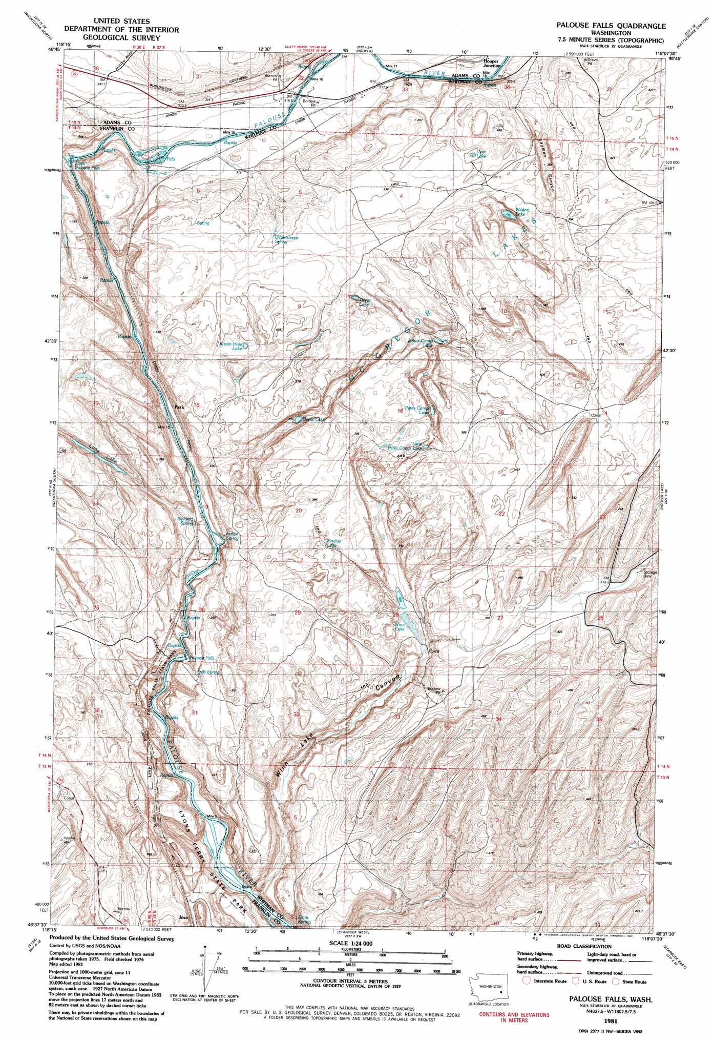
USGS Topo Quad 46118f2 - 1:24,000 scale
| Topo Map Name: | Palouse Falls |
| USGS Topo Quad ID: | 46118f2 |
| Print Size: | ca. 21 1/4" wide x 27" high |
| Southeast Coordinates: | 46.625° N latitude / 118.125° W longitude |
| Map Center Coordinates: | 46.6875° N latitude / 118.1875° W longitude |
| U.S. State: | WA |
| Filename: | o46118f2.jpg |
| Download Map JPG Image: | Palouse Falls topo map 1:24,000 scale |
| Map Type: | Topographic |
| Topo Series: | 7.5´ |
| Map Scale: | 1:24,000 |
| Source of Map Images: | United States Geological Survey (USGS) |
| Alternate Map Versions: |
Palouse Falls WA 1981, updated 1981 Download PDF Buy paper map Palouse Falls WA 2011 Download PDF Buy paper map Palouse Falls WA 2014 Download PDF Buy paper map |
1:24,000 Topo Quads surrounding Palouse Falls
Pizarro |
Ralston |
Coyote Butte |
Benge |
Honn Lakes |
West Of Washtucna |
Washtucna North |
Hooper |
Rattlesnake Canyon |
La Crosse West |
Sperry |
Washtucna South |
Palouse Falls |
Hooper Lake |
Hay |
Monumental Rock |
Ayer |
Starbuck West |
Starbuck East |
Delaney |
Clyde |
Pleasant View |
Waitsburg Nw |
Kellogg Creek |
Tucannon |
> Back to 46118e1 at 1:100,000 scale
> Back to 46118a1 at 1:250,000 scale
> Back to U.S. Topo Maps home
Palouse Falls topo map: Gazetteer
Palouse Falls: Areas
McGregor Lakes elevation 374m 1227′Palouse Falls: Dams
McGregory Dam elevation 396m 1299′Palouse Falls: Falls
Little Palouse Falls elevation 291m 954′Palouse Falls elevation 219m 718′
Palouse Falls: Lakes
Devils Lake elevation 303m 994′Dyer Lake elevation 395m 1295′
Findley Lake elevation 371m 1217′
Green Lake elevation 368m 1207′
Johns Camp Lake elevation 344m 1128′
Little Petes Camp Lake elevation 365m 1197′
Long Lake elevation 329m 1079′
Petes Camp Lake elevation 337m 1105′
Rustin Hole Lake elevation 390m 1279′
Wildcat Lake elevation 340m 1115′
Winn Lake elevation 337m 1105′
Palouse Falls: Parks
Palouse Falls State Park elevation 239m 784′Palouse Falls: Springs
Falls Spring elevation 292m 958′Gildersleeve Spring elevation 368m 1207′
Indian Spring elevation 307m 1007′
Railroad Spring elevation 283m 928′
Palouse Falls: Summits
Fryxell Overlook elevation 278m 912′Palouse Falls: Valleys
Holliday Coulee elevation 290m 951′Layman Canyon elevation 399m 1309′
Winn Lake Canyon elevation 253m 830′
Palouse Falls digital topo map on disk
Buy this Palouse Falls topo map showing relief, roads, GPS coordinates and other geographical features, as a high-resolution digital map file on DVD: