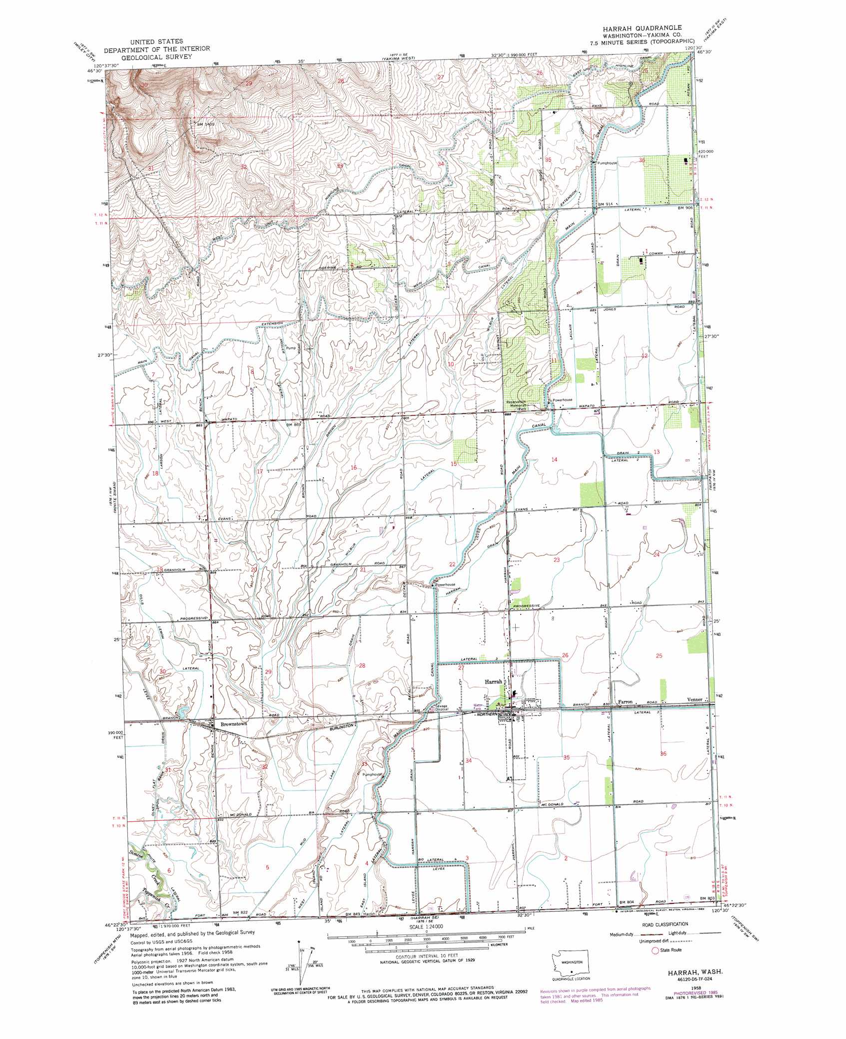
Harrah Topo Map Washington
To zoom in, hover over the map of Harrah
USGS Topo Quad 46120d5 - 1:24,000 scale
| Topo Map Name: | Harrah |
| USGS Topo Quad ID: | 46120d5 |
| Print Size: | ca. 21 1/4" wide x 27" high |
| Southeast Coordinates: | 46.375° N latitude / 120.5° W longitude |
| Map Center Coordinates: | 46.4375° N latitude / 120.5625° W longitude |
| U.S. State: | WA |
| Filename: | o46120d5.jpg |
| Download Map JPG Image: | Harrah topo map 1:24,000 scale |
| Map Type: | Topographic |
| Topo Series: | 7.5´ |
| Map Scale: | 1:24,000 |
| Source of Map Images: | United States Geological Survey (USGS) |
| Alternate Map Versions: |
Harrah WA 1958, updated 1960 Download PDF Buy paper map Harrah WA 1958, updated 1975 Download PDF Buy paper map Harrah WA 1958, updated 1985 Download PDF Buy paper map Harrah WA 2011 Download PDF Buy paper map Harrah WA 2013 Download PDF Buy paper map |
1:24,000 Topo Quads surrounding Harrah
Tieton |
Naches |
Selah |
Pomona |
Selah Springs |
Tampico |
Wiley City |
Yakima West |
Yakima East |
Elephant Mountain |
Medicine Valley |
White Swan |
Harrah |
Wapato |
Toppenish |
Fort Simcoe |
Toppenish Mountain |
Harrah Se |
Toppenish Sw |
Hembre Mountain |
Camas Patch |
Logy Creek Falls |
Logy Creek Ne |
Poisel Butte Nw |
Poisel Butte |
> Back to 46120a1 at 1:100,000 scale
> Back to 46120a1 at 1:250,000 scale
> Back to U.S. Topo Maps home
Harrah topo map: Gazetteer
Harrah: Airports
Labbee Field elevation 246m 807′Harrah: Canals
Brown Lateral elevation 272m 892′Dills Lemon Lateral elevation 263m 862′
East Island Lateral elevation 257m 843′
Laclair Drain elevation 272m 892′
Larson Lateral elevation 273m 895′
Lateral 1 elevation 277m 908′
Main Canal elevation 269m 882′
Mud Lake Drain elevation 251m 823′
Old Wilbur Lateral elevation 280m 918′
Olney Flat Drain elevation 256m 839′
Piute Lateral elevation 254m 833′
Vogler Lateral elevation 276m 905′
Wilbur Lateral elevation 266m 872′
Harrah: Parks
Reservation Memorial Park elevation 275m 902′Harrah: Populated Places
Brownstown elevation 260m 853′Farron elevation 254m 833′
Harrah elevation 254m 833′
Venner elevation 254m 833′
Harrah: Streams
Simcoe Creek elevation 250m 820′Harrah: Valleys
Yakima Valley elevation 257m 843′Harrah digital topo map on disk
Buy this Harrah topo map showing relief, roads, GPS coordinates and other geographical features, as a high-resolution digital map file on DVD: