Selah Topo Map Washington
To zoom in, hover over the map of Selah
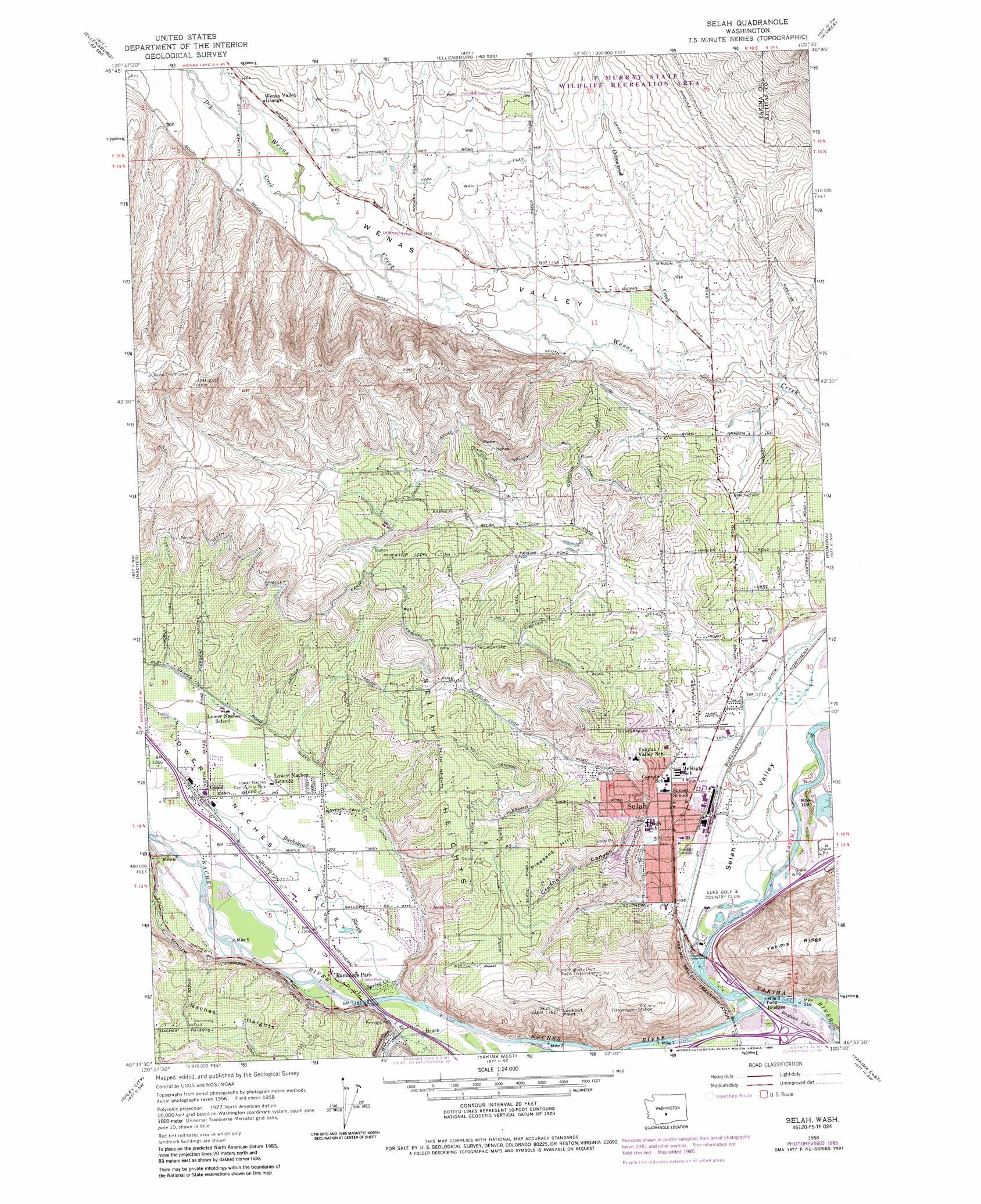
USGS Topo Quad 46120f5 - 1:24,000 scale
| Topo Map Name: | Selah |
| USGS Topo Quad ID: | 46120f5 |
| Print Size: | ca. 21 1/4" wide x 27" high |
| Southeast Coordinates: | 46.625° N latitude / 120.5° W longitude |
| Map Center Coordinates: | 46.6875° N latitude / 120.5625° W longitude |
| U.S. State: | WA |
| Filename: | o46120f5.jpg |
| Download Map JPG Image: | Selah topo map 1:24,000 scale |
| Map Type: | Topographic |
| Topo Series: | 7.5´ |
| Map Scale: | 1:24,000 |
| Source of Map Images: | United States Geological Survey (USGS) |
| Alternate Map Versions: |
Selah WA 1958, updated 1960 Download PDF Buy paper map Selah WA 1958, updated 1975 Download PDF Buy paper map Selah WA 1958, updated 1985 Download PDF Buy paper map Selah WA 1958, updated 1985 Download PDF Buy paper map Selah WA 2011 Download PDF Buy paper map Selah WA 2013 Download PDF Buy paper map |
1:24,000 Topo Quads surrounding Selah
Hudson Creek |
Manastash Creek |
Ellensburg South |
Kittitas |
East Kittitas |
Milk Canyon |
Wenas Lake |
The Cottonwoods |
Wymer |
Badger Gap |
Tieton |
Naches |
Selah |
Pomona |
Selah Springs |
Tampico |
Wiley City |
Yakima West |
Yakima East |
Elephant Mountain |
Medicine Valley |
White Swan |
Harrah |
Wapato |
Toppenish |
> Back to 46120e1 at 1:100,000 scale
> Back to 46120a1 at 1:250,000 scale
> Back to U.S. Topo Maps home
Selah topo map: Gazetteer
Selah: Canals
Gleed Ditch elevation 401m 1315′Number 1 Lateral elevation 473m 1551′
Number 2 Lateral elevation 441m 1446′
Selah: Cliffs
Lookout Point elevation 538m 1765′Selah: Flats
Iowa Flat elevation 433m 1420′Selah: Lakes
Rotary Lake elevation 330m 1082′Selah: Parks
Carlon Park elevation 342m 1122′Indian Painted Rocks State Park elevation 369m 1210′
Legion Park elevation 355m 1164′
Lower Naches Community Park elevation 383m 1256′
Palm Park elevation 396m 1299′
Wixon Park elevation 339m 1112′
Selah: Populated Places
Brace elevation 354m 1161′Gleed elevation 382m 1253′
Selah elevation 341m 1118′
Selah: Reservoirs
Berglund Lake elevation 330m 1082′Selah: Streams
Buckskin Slough elevation 354m 1161′Cottonwood Creek elevation 368m 1207′
Cowiche Creek elevation 347m 1138′
Dry Creek elevation 423m 1387′
Naches River elevation 329m 1079′
Spring Creek elevation 355m 1164′
Selah: Summits
Pleasant Hill elevation 451m 1479′Selah Heights elevation 477m 1564′
Selah: Valleys
Cowiche Canyon elevation 360m 1181′Crusher Canyon elevation 348m 1141′
Lower Naches Valley elevation 357m 1171′
Selah Valley elevation 336m 1102′
Wenas Valley elevation 371m 1217′
Selah digital topo map on disk
Buy this Selah topo map showing relief, roads, GPS coordinates and other geographical features, as a high-resolution digital map file on DVD: