Manastash Lake Topo Map Washington
To zoom in, hover over the map of Manastash Lake
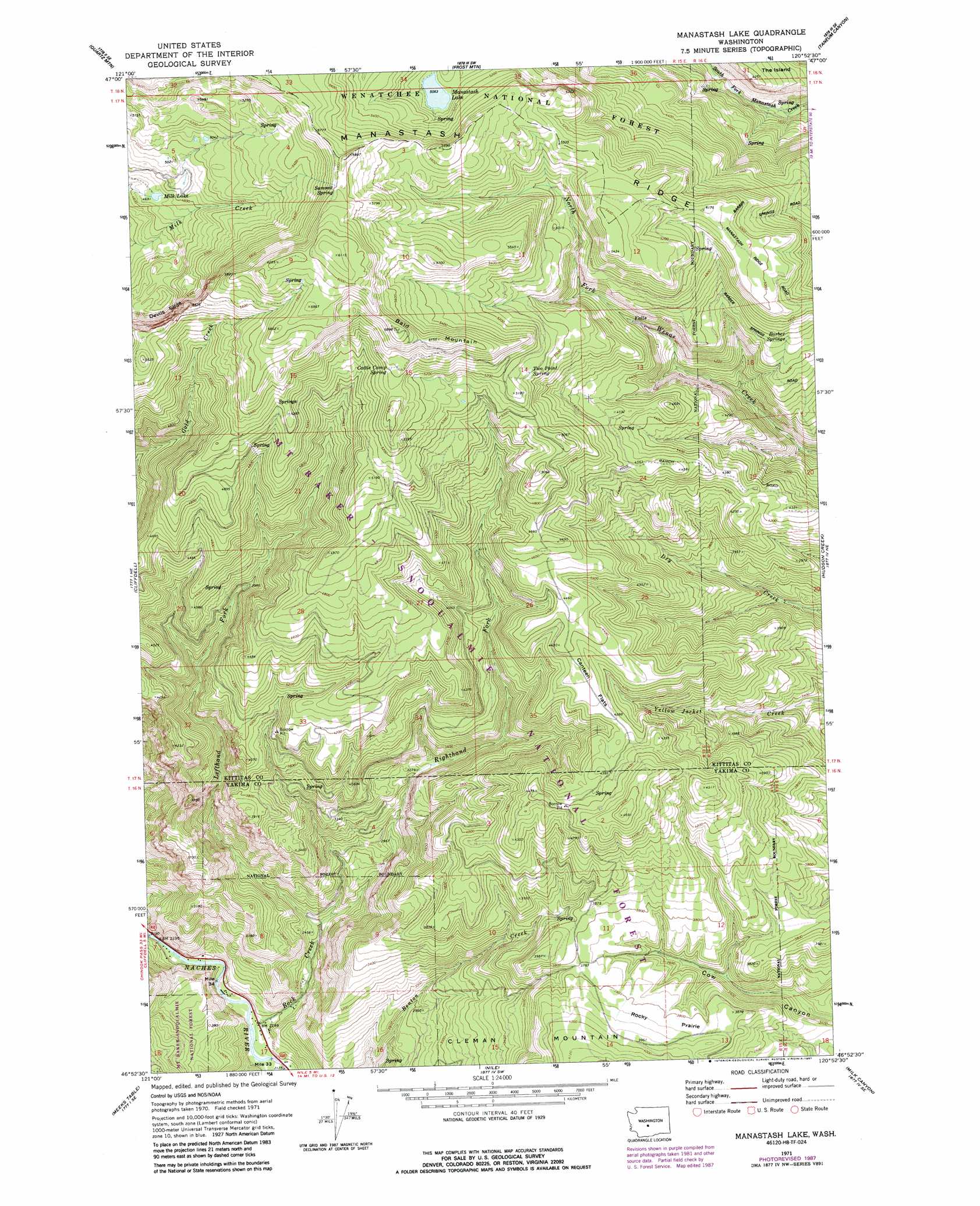
USGS Topo Quad 46120h8 - 1:24,000 scale
| Topo Map Name: | Manastash Lake |
| USGS Topo Quad ID: | 46120h8 |
| Print Size: | ca. 21 1/4" wide x 27" high |
| Southeast Coordinates: | 46.875° N latitude / 120.875° W longitude |
| Map Center Coordinates: | 46.9375° N latitude / 120.9375° W longitude |
| U.S. State: | WA |
| Filename: | o46120h8.jpg |
| Download Map JPG Image: | Manastash Lake topo map 1:24,000 scale |
| Map Type: | Topographic |
| Topo Series: | 7.5´ |
| Map Scale: | 1:24,000 |
| Source of Map Images: | United States Geological Survey (USGS) |
| Alternate Map Versions: |
Manastash Lake WA 1971, updated 1974 Download PDF Buy paper map Manastash Lake WA 1971, updated 1987 Download PDF Buy paper map Manastash Lake WA 1992, updated 1996 Download PDF Buy paper map Manastash Lake WA 2000, updated 2001 Download PDF Buy paper map Manastash Lake WA 2011 Download PDF Buy paper map Manastash Lake WA 2013 Download PDF Buy paper map |
| FStopo: | US Forest Service topo Manastash Lake is available: Download FStopo PDF Download FStopo TIF |
1:24,000 Topo Quads surrounding Manastash Lake
Easton |
Ronald |
Cle Elum |
Teanaway |
Swauk Prairie |
Mount Clifty |
Quartz Mountain |
Frost Mountain |
Taneum Canyon |
Thorp |
Old Scab Mountain |
Cliffdell |
Manastash Lake |
Hudson Creek |
Manastash Creek |
Timberwolf Mountain |
Meeks Table |
Nile |
Milk Canyon |
Wenas Lake |
Rimrock Lake |
Tieton Basin |
Weddle Canyon |
Tieton |
Naches |
> Back to 46120e1 at 1:100,000 scale
> Back to 46120a1 at 1:250,000 scale
> Back to U.S. Topo Maps home
Manastash Lake topo map: Gazetteer
Manastash Lake: Cliffs
Devils Slide elevation 1579m 5180′Manastash Lake: Flats
Canteen Flats elevation 1321m 4333′Rocky Prairie elevation 1167m 3828′
Manastash Lake: Gaps
Rocky Saddle elevation 1644m 5393′Manastash Lake: Lakes
Manastash Lake elevation 1544m 5065′Milk Lake elevation 1434m 4704′
Manastash Lake: Springs
Barber Springs elevation 1393m 4570′Cattle Camp Spring elevation 1659m 5442′
Summit Spring elevation 1779m 5836′
Two Point Spring elevation 1545m 5068′
Manastash Lake: Streams
Lefthand Fork Rock Creek elevation 733m 2404′Righthand Fork Rock Creek elevation 733m 2404′
Rock Creek elevation 652m 2139′
Manastash Lake: Summits
Bald Mountain elevation 1744m 5721′The Island elevation 1206m 3956′
Manastash Lake: Trails
Gold Creek Trail elevation 1687m 5534′Summit Trail elevation 1818m 5964′
Manastash Lake digital topo map on disk
Buy this Manastash Lake topo map showing relief, roads, GPS coordinates and other geographical features, as a high-resolution digital map file on DVD: