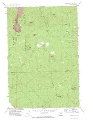
King Mountain Topo Map Washington
To zoom in, hover over the map of King Mountain
USGS Topo Quad 46121a4 - 1:24,000 scale
| Topo Map Name: | King Mountain |
| USGS Topo Quad ID: | 46121a4 |
| Print Size: | ca. 21 1/4" wide x 27" high |
| Southeast Coordinates: | 46° N latitude / 121.375° W longitude |
| Map Center Coordinates: | 46.0625° N latitude / 121.4375° W longitude |
| U.S. State: | WA |
| Filename: | o46121a4.jpg |
| Download Map JPG Image: | King Mountain topo map 1:24,000 scale |
| Map Type: | Topographic |
| Topo Series: | 7.5´ |
| Map Scale: | 1:24,000 |
| Source of Map Images: | United States Geological Survey (USGS) |
| Alternate Map Versions: |
King Mountain WA 1971, updated 1973 Download PDF Buy paper map King Mountain WA 1998, updated 2003 Download PDF Buy paper map King Mountain WA 2011 Download PDF Buy paper map King Mountain WA 2014 Download PDF Buy paper map |
| FStopo: | US Forest Service topo King Mountain is available: Download FStopo PDF Download FStopo TIF |
1:24,000 Topo Quads surrounding King Mountain
> Back to 46121a1 at 1:100,000 scale
> Back to 46120a1 at 1:250,000 scale
> Back to U.S. Topo Maps home
King Mountain topo map: Gazetteer
King Mountain: Lavas
A G Aiken Lava Bed elevation 1501m 4924′King Mountain: Springs
Mud Spring elevation 850m 2788′King Mountain: Summits
Bunnell Butte elevation 1245m 4084′King Mountain elevation 1438m 4717′
Meadow Butte elevation 1091m 3579′
Red Butte elevation 947m 3106′
Smith Butte elevation 1319m 4327′
Snipes Mountain elevation 1445m 4740′
Snowplow Mountain elevation 1540m 5052′
King Mountain digital topo map on disk
Buy this King Mountain topo map showing relief, roads, GPS coordinates and other geographical features, as a high-resolution digital map file on DVD:


