Trout Lake Topo Map Washington
To zoom in, hover over the map of Trout Lake
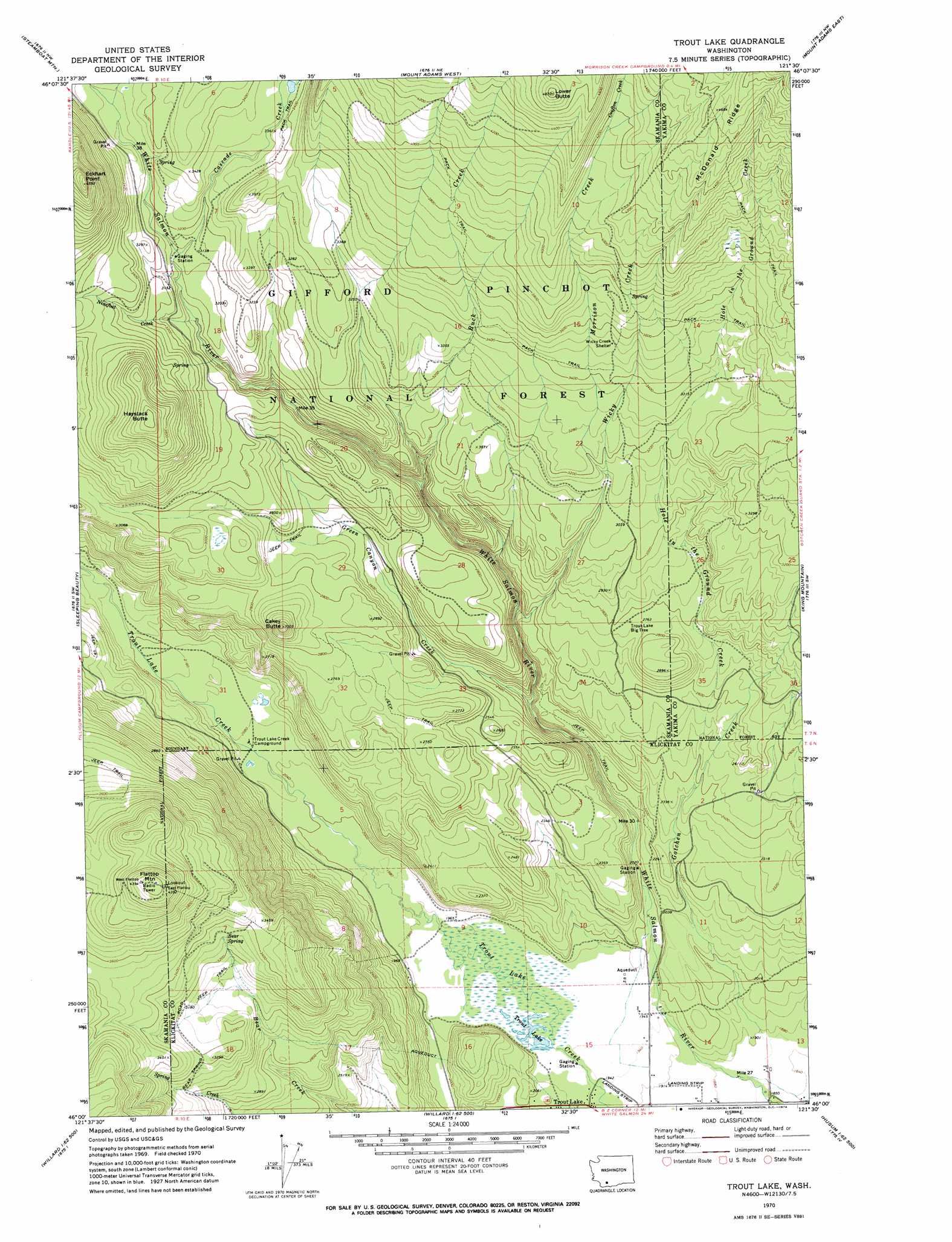
USGS Topo Quad 46121a5 - 1:24,000 scale
| Topo Map Name: | Trout Lake |
| USGS Topo Quad ID: | 46121a5 |
| Print Size: | ca. 21 1/4" wide x 27" high |
| Southeast Coordinates: | 46° N latitude / 121.5° W longitude |
| Map Center Coordinates: | 46.0625° N latitude / 121.5625° W longitude |
| U.S. State: | WA |
| Filename: | o46121a5.jpg |
| Download Map JPG Image: | Trout Lake topo map 1:24,000 scale |
| Map Type: | Topographic |
| Topo Series: | 7.5´ |
| Map Scale: | 1:24,000 |
| Source of Map Images: | United States Geological Survey (USGS) |
| Alternate Map Versions: |
Trout Lake WA 1970, updated 1973 Download PDF Buy paper map Trout Lake WA 1998, updated 2003 Download PDF Buy paper map Trout Lake WA 2011 Download PDF Buy paper map Trout Lake WA 2014 Download PDF Buy paper map |
| FStopo: | US Forest Service topo Trout Lake is available: Download FStopo PDF Download FStopo TIF |
1:24,000 Topo Quads surrounding Trout Lake
Mccoy Peak |
East Canyon Ridge |
Green Mountain |
Glaciate Butte |
Windy Point |
Quartz Creek Butte |
Steamboat Mountain |
Mount Adams West |
Mount Adams East |
Jungle Butte |
Lone Butte |
Sleeping Beauty |
Trout Lake |
King Mountain |
Glenwood |
Gifford Peak |
Little Huckleberry Mountain |
Guler Mountain |
Quigley Butte |
Camas Prairie |
Big Huckleberry Mountain |
Willard |
Northwestern Lake |
Husum |
Appleton |
> Back to 46121a1 at 1:100,000 scale
> Back to 46120a1 at 1:250,000 scale
> Back to U.S. Topo Maps home
Trout Lake topo map: Gazetteer
Trout Lake: Airports
Hollenbeck Landing Strip elevation 590m 1935′Trout Lake Airport elevation 581m 1906′
Trout Lake: Lakes
Trout Lake elevation 595m 1952′Trout Lake: Ridges
McDonald Ridge elevation 1466m 4809′Trout Lake: Springs
Bear Spring elevation 1001m 3284′Trout Lake: Streams
Buck Creek elevation 805m 2641′Cascade Creek elevation 944m 3097′
Crofton Creek elevation 1268m 4160′
Gotchen Creek elevation 572m 1876′
Green Canyon Creek elevation 682m 2237′
Hole in the Ground Creek elevation 722m 2368′
Morrison Creek elevation 728m 2388′
Ninefoot Creek elevation 916m 3005′
Wicky Creek elevation 936m 3070′
Trout Lake: Summits
Cakey Butte elevation 1007m 3303′Eckhart Point elevation 1393m 4570′
Flattop Mountain elevation 1347m 4419′
Haystack Butte elevation 1224m 4015′
Lower Butte elevation 1473m 4832′
Trout Lake: Valleys
Green Canyon elevation 685m 2247′Trout Lake digital topo map on disk
Buy this Trout Lake topo map showing relief, roads, GPS coordinates and other geographical features, as a high-resolution digital map file on DVD: