Steamboat Mountain Topo Map Washington
To zoom in, hover over the map of Steamboat Mountain
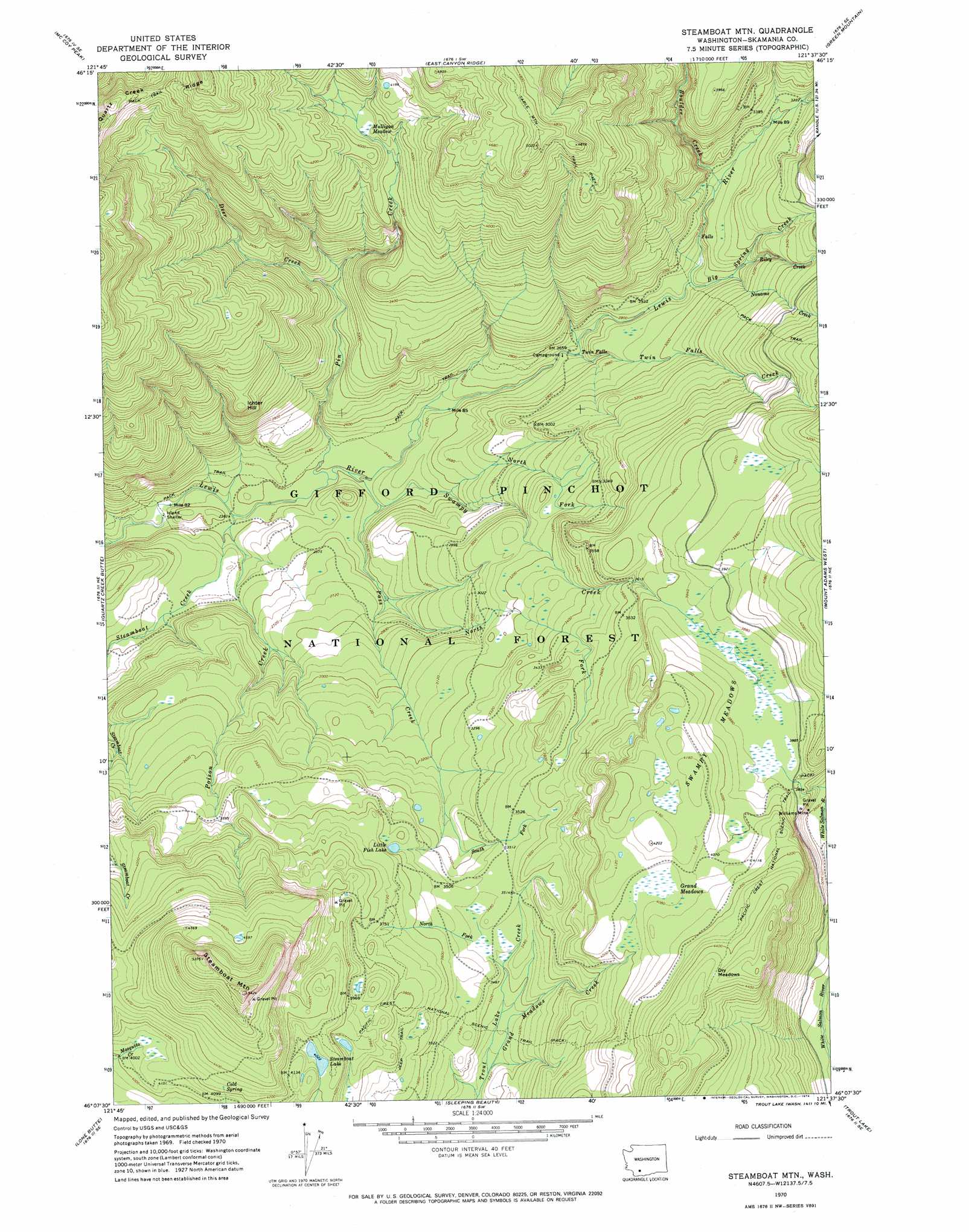
USGS Topo Quad 46121b6 - 1:24,000 scale
| Topo Map Name: | Steamboat Mountain |
| USGS Topo Quad ID: | 46121b6 |
| Print Size: | ca. 21 1/4" wide x 27" high |
| Southeast Coordinates: | 46.125° N latitude / 121.625° W longitude |
| Map Center Coordinates: | 46.1875° N latitude / 121.6875° W longitude |
| U.S. State: | WA |
| Filename: | o46121b6.jpg |
| Download Map JPG Image: | Steamboat Mountain topo map 1:24,000 scale |
| Map Type: | Topographic |
| Topo Series: | 7.5´ |
| Map Scale: | 1:24,000 |
| Source of Map Images: | United States Geological Survey (USGS) |
| Alternate Map Versions: |
Steamboat Mtn. WA 1970, updated 1974 Download PDF Buy paper map Steamboat Mountain WA 1998, updated 2003 Download PDF Buy paper map Steamboat Mountain WA 2011 Download PDF Buy paper map Steamboat Mountain WA 2014 Download PDF Buy paper map |
| FStopo: | US Forest Service topo Steamboat Mountain is available: Download FStopo PDF Download FStopo TIF |
1:24,000 Topo Quads surrounding Steamboat Mountain
Greenhorn Buttes |
Tower Rock |
Blue Lake |
Hamilton Buttes |
Walupt Lake |
French Butte |
Mccoy Peak |
East Canyon Ridge |
Green Mountain |
Glaciate Butte |
Spencer Butte |
Quartz Creek Butte |
Steamboat Mountain |
Mount Adams West |
Mount Adams East |
Burnt Peak |
Lone Butte |
Sleeping Beauty |
Trout Lake |
King Mountain |
Termination Point |
Gifford Peak |
Little Huckleberry Mountain |
Guler Mountain |
Quigley Butte |
> Back to 46121a1 at 1:100,000 scale
> Back to 46120a1 at 1:250,000 scale
> Back to U.S. Topo Maps home
Steamboat Mountain topo map: Gazetteer
Steamboat Mountain: Areas
Steamboat Mountain Research Natural Area elevation 1532m 5026′Steamboat Mountain: Falls
Twin Falls elevation 806m 2644′Steamboat Mountain: Flats
Dry Meadows elevation 1358m 4455′Grand Meadows elevation 1242m 4074′
Mulligan Meadow elevation 1209m 3966′
Swampy Meadows elevation 1207m 3959′
Steamboat Mountain: Lakes
Little Fish Lake elevation 1083m 3553′Steamboat Lake elevation 1227m 4025′
Steamboat Mountain: Mines
Williams Mine elevation 1107m 3631′Steamboat Mountain: Springs
Cold Spring elevation 1303m 4274′Steamboat Mountain: Streams
Big Spring Creek elevation 886m 2906′Boulder Creek elevation 930m 3051′
Deer Creek elevation 905m 2969′
Grand Meadows Creek elevation 996m 3267′
Noname Creek elevation 902m 2959′
North Fork Pass Creek elevation 807m 2647′
North Fork Swampy Creek elevation 786m 2578′
North Fork Trout Lake Creek elevation 1039m 3408′
Pass Creek elevation 747m 2450′
Pin Creek elevation 726m 2381′
Poison Creek elevation 721m 2365′
Riley Creek elevation 921m 3021′
South Fork Pass Creek elevation 1011m 3316′
Steamboat Creek elevation 721m 2365′
Swampy Creek elevation 733m 2404′
Twin Falls Creek elevation 828m 2716′
Steamboat Mountain: Summits
Ichter Hill elevation 1064m 3490′Steamboat Mountain elevation 1640m 5380′
Steamboat Mountain: Trails
Table Mountain Trail elevation 1509m 4950′Steamboat Mountain digital topo map on disk
Buy this Steamboat Mountain topo map showing relief, roads, GPS coordinates and other geographical features, as a high-resolution digital map file on DVD: