Quartz Creek Butte Topo Map Washington
To zoom in, hover over the map of Quartz Creek Butte
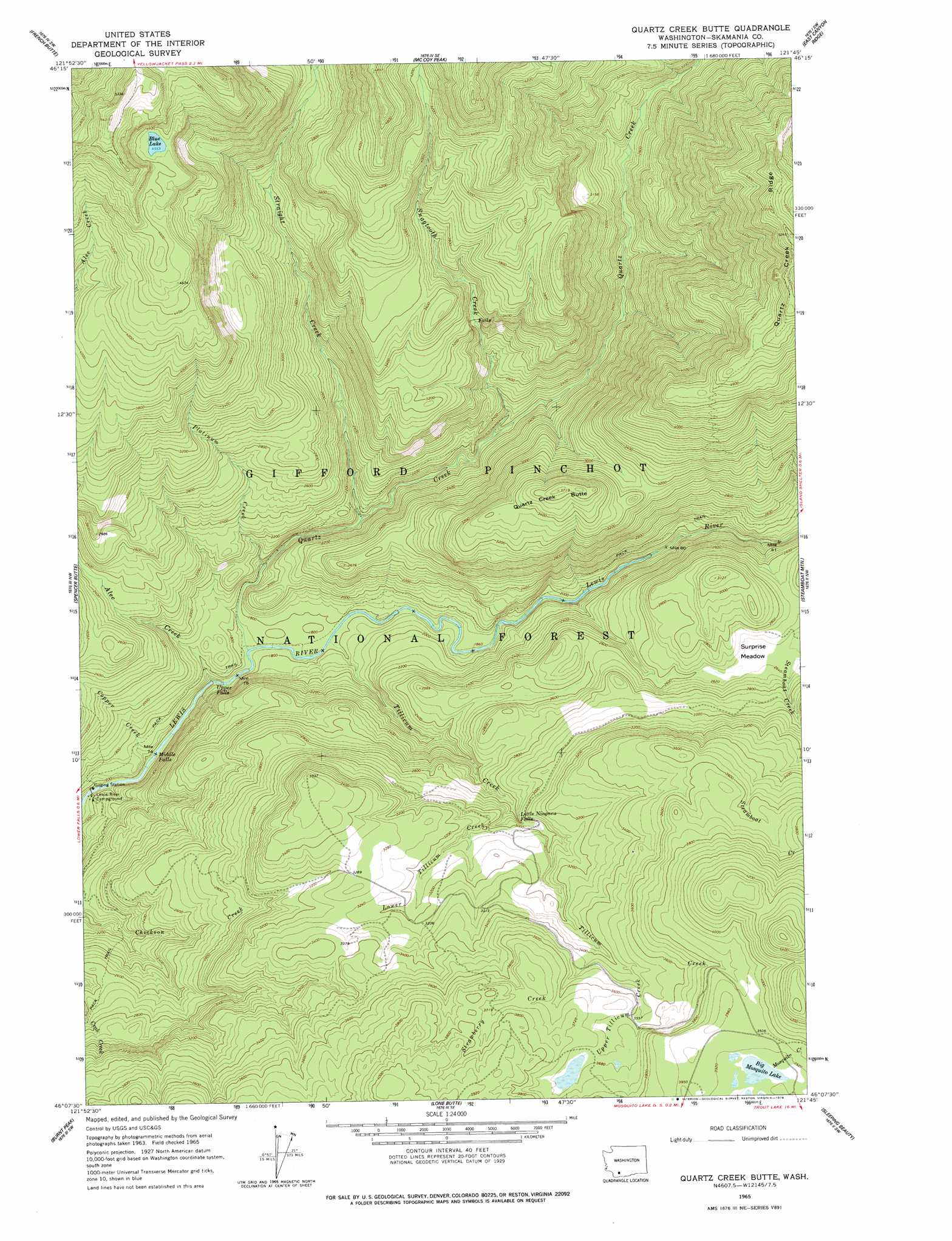
USGS Topo Quad 46121b7 - 1:24,000 scale
| Topo Map Name: | Quartz Creek Butte |
| USGS Topo Quad ID: | 46121b7 |
| Print Size: | ca. 21 1/4" wide x 27" high |
| Southeast Coordinates: | 46.125° N latitude / 121.75° W longitude |
| Map Center Coordinates: | 46.1875° N latitude / 121.8125° W longitude |
| U.S. State: | WA |
| Filename: | o46121b7.jpg |
| Download Map JPG Image: | Quartz Creek Butte topo map 1:24,000 scale |
| Map Type: | Topographic |
| Topo Series: | 7.5´ |
| Map Scale: | 1:24,000 |
| Source of Map Images: | United States Geological Survey (USGS) |
| Alternate Map Versions: |
Quartz Creek Butte WA 1965, updated 1967 Download PDF Buy paper map Quartz Creek Butte WA 1965, updated 1978 Download PDF Buy paper map Quartz Creek Butte WA 1998, updated 2003 Download PDF Buy paper map Quartz Creek Butte WA 2011 Download PDF Buy paper map Quartz Creek Butte WA 2014 Download PDF Buy paper map |
| FStopo: | US Forest Service topo Quartz Creek Butte is available: Download FStopo PDF Download FStopo TIF |
1:24,000 Topo Quads surrounding Quartz Creek Butte
Cowlitz Falls |
Greenhorn Buttes |
Tower Rock |
Blue Lake |
Hamilton Buttes |
Spirit Lake East |
French Butte |
Mccoy Peak |
East Canyon Ridge |
Green Mountain |
Smith Creek Butte |
Spencer Butte |
Quartz Creek Butte |
Steamboat Mountain |
Mount Adams West |
Cedar Flats |
Burnt Peak |
Lone Butte |
Sleeping Beauty |
Trout Lake |
Bare Mountain |
Termination Point |
Gifford Peak |
Little Huckleberry Mountain |
Guler Mountain |
> Back to 46121a1 at 1:100,000 scale
> Back to 46120a1 at 1:250,000 scale
> Back to U.S. Topo Maps home
Quartz Creek Butte topo map: Gazetteer
Quartz Creek Butte: Falls
Little Niagara Falls elevation 902m 2959′Middle Falls elevation 481m 1578′
Upper Falls elevation 503m 1650′
Quartz Creek Butte: Flats
Surprise Meadow elevation 803m 2634′Quartz Creek Butte: Lakes
Big Mosquito Lake elevation 1187m 3894′Blue Lake elevation 1389m 4557′
Quartz Creek Butte: Ridges
Quartz Creek Ridge elevation 1577m 5173′Quartz Creek Butte: Streams
Alec Creek elevation 489m 1604′Copper Creek elevation 473m 1551′
Lower Tillicum Creek elevation 848m 2782′
Platinum Creek elevation 550m 1804′
Quartz Creek elevation 528m 1732′
Snagtooth Creek elevation 647m 2122′
Straight Creek elevation 585m 1919′
Strawberry Creek elevation 1012m 3320′
Tillicum Creek elevation 540m 1771′
Upper Tillicum Creek elevation 1045m 3428′
Quartz Creek Butte: Summits
Quartz Creek Butte elevation 1123m 3684′Quartz Creek Butte digital topo map on disk
Buy this Quartz Creek Butte topo map showing relief, roads, GPS coordinates and other geographical features, as a high-resolution digital map file on DVD: