Hamilton Buttes Topo Map Washington
To zoom in, hover over the map of Hamilton Buttes
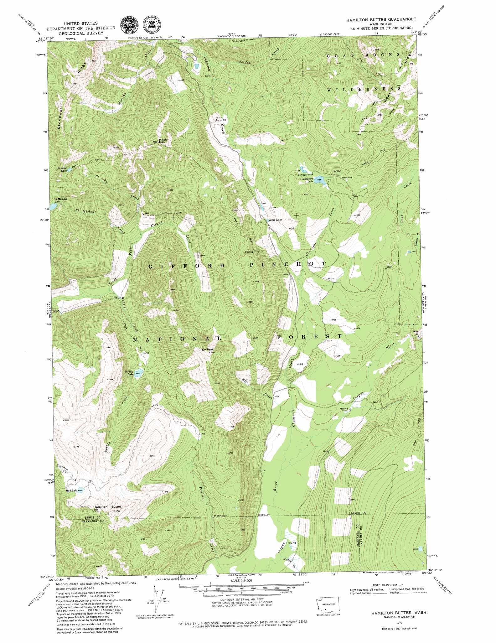
USGS Topo Quad 46121d5 - 1:24,000 scale
| Topo Map Name: | Hamilton Buttes |
| USGS Topo Quad ID: | 46121d5 |
| Print Size: | ca. 21 1/4" wide x 27" high |
| Southeast Coordinates: | 46.375° N latitude / 121.5° W longitude |
| Map Center Coordinates: | 46.4375° N latitude / 121.5625° W longitude |
| U.S. State: | WA |
| Filename: | o46121d5.jpg |
| Download Map JPG Image: | Hamilton Buttes topo map 1:24,000 scale |
| Map Type: | Topographic |
| Topo Series: | 7.5´ |
| Map Scale: | 1:24,000 |
| Source of Map Images: | United States Geological Survey (USGS) |
| Alternate Map Versions: |
Hamilton Buttes WA 1970, updated 1973 Download PDF Buy paper map Hamilton Buttes WA 1994, updated 1996 Download PDF Buy paper map Hamilton Buttes WA 2011 Download PDF Buy paper map Hamilton Buttes WA 2014 Download PDF Buy paper map |
| FStopo: | US Forest Service topo Hamilton Buttes is available: Download FStopo PDF Download FStopo TIF |
1:24,000 Topo Quads surrounding Hamilton Buttes
Wahpenayo Peak |
Tatoosh Lakes |
Ohanapecosh Hot Springs |
White Pass |
Spiral Butte |
Purcell Mountain |
Packwood |
Packwood Lake |
Old Snowy Mountain |
Pinegrass Ridge |
Tower Rock |
Blue Lake |
Hamilton Buttes |
Walupt Lake |
Jennies Butte |
Mccoy Peak |
East Canyon Ridge |
Green Mountain |
Glaciate Butte |
Windy Point |
Quartz Creek Butte |
Steamboat Mountain |
Mount Adams West |
Mount Adams East |
Jungle Butte |
> Back to 46121a1 at 1:100,000 scale
> Back to 46120a1 at 1:250,000 scale
> Back to U.S. Topo Maps home
Hamilton Buttes topo map: Gazetteer
Hamilton Buttes: Arches
Sanctuary Arch elevation 1652m 5419′Hamilton Buttes: Lakes
Chambers Lake elevation 1354m 4442′Hugo Lake elevation 1227m 4025′
Mud Lake elevation 1485m 4872′
Saint John Lake elevation 1558m 5111′
Wobbly Lake elevation 1021m 3349′
Wright Lake elevation 904m 2965′
Hamilton Buttes: Populated Places
Berry Patch elevation 1419m 4655′Hamilton Buttes: Ridges
Goat Ridge elevation 1883m 6177′Stonewall Ridge elevation 1810m 5938′
Hamilton Buttes: Streams
Cispus River elevation 945m 3100′Elk Creek elevation 963m 3159′
Goat Creek elevation 1156m 3792′
Jordan Creek elevation 908m 2979′
Saint John Creek elevation 933m 3061′
Saint Michael Creek elevation 910m 2985′
Wesley Creek elevation 936m 3070′
Wobbly Creek elevation 851m 2791′
Hamilton Buttes: Summits
Elk Peak elevation 1668m 5472′Hamilton Buttes elevation 1721m 5646′
Mission Mountain elevation 1705m 5593′
Hamilton Buttes digital topo map on disk
Buy this Hamilton Buttes topo map showing relief, roads, GPS coordinates and other geographical features, as a high-resolution digital map file on DVD: