Tower Rock Topo Map Washington
To zoom in, hover over the map of Tower Rock
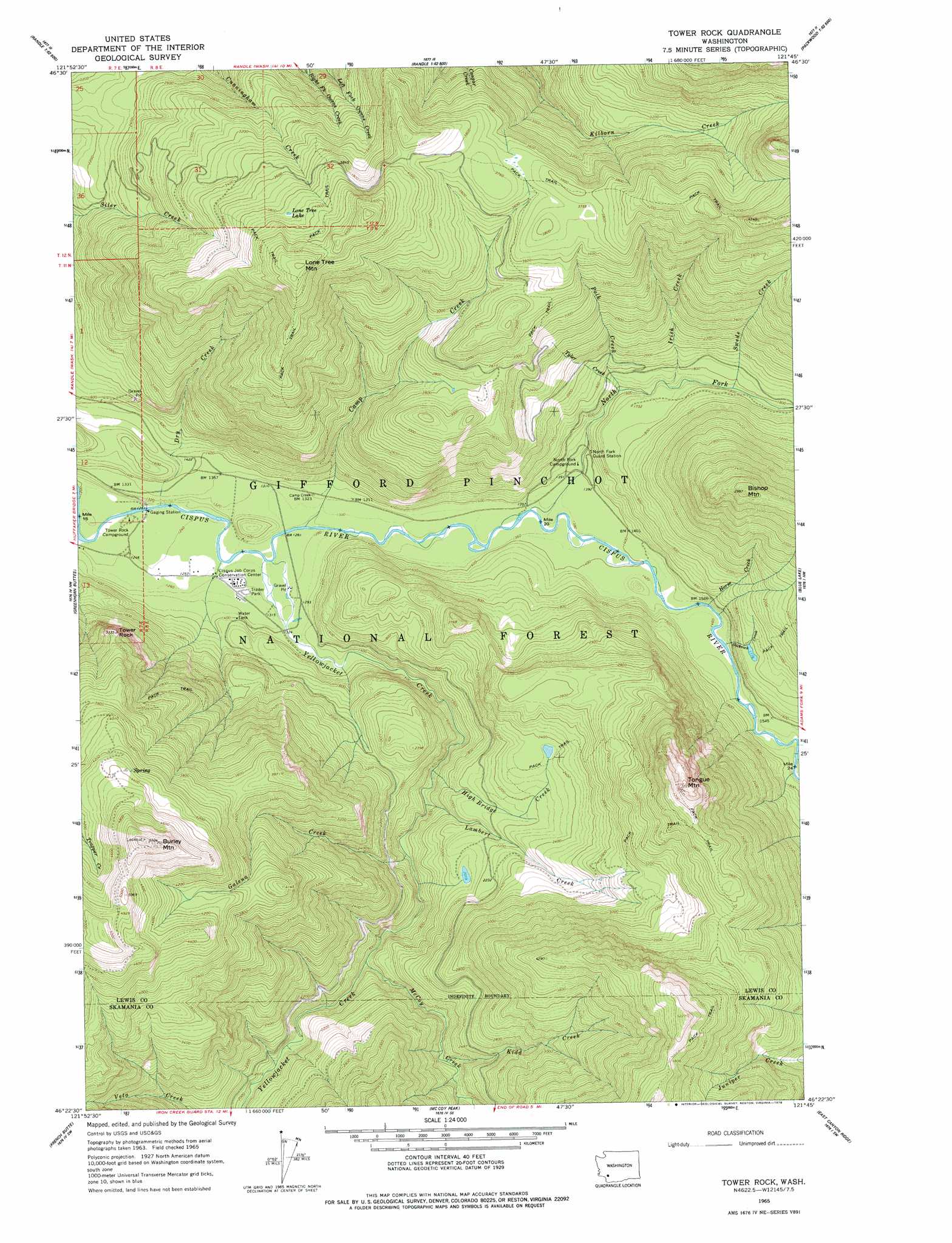
USGS Topo Quad 46121d7 - 1:24,000 scale
| Topo Map Name: | Tower Rock |
| USGS Topo Quad ID: | 46121d7 |
| Print Size: | ca. 21 1/4" wide x 27" high |
| Southeast Coordinates: | 46.375° N latitude / 121.75° W longitude |
| Map Center Coordinates: | 46.4375° N latitude / 121.8125° W longitude |
| U.S. State: | WA |
| Filename: | o46121d7.jpg |
| Download Map JPG Image: | Tower Rock topo map 1:24,000 scale |
| Map Type: | Topographic |
| Topo Series: | 7.5´ |
| Map Scale: | 1:24,000 |
| Source of Map Images: | United States Geological Survey (USGS) |
| Alternate Map Versions: |
Tower Rock WA 1965, updated 1967 Download PDF Buy paper map Tower Rock WA 1965, updated 1978 Download PDF Buy paper map Tower Rock WA 1994, updated 1996 Download PDF Buy paper map Tower Rock WA 2011 Download PDF Buy paper map Tower Rock WA 2014 Download PDF Buy paper map |
| FStopo: | US Forest Service topo Tower Rock is available: Download FStopo PDF Download FStopo TIF |
1:24,000 Topo Quads surrounding Tower Rock
Anderson Lake |
Sawtooth Ridge |
Wahpenayo Peak |
Tatoosh Lakes |
Ohanapecosh Hot Springs |
Kiona Peak |
Randle |
Purcell Mountain |
Packwood |
Packwood Lake |
Cowlitz Falls |
Greenhorn Buttes |
Tower Rock |
Blue Lake |
Hamilton Buttes |
Spirit Lake East |
French Butte |
Mccoy Peak |
East Canyon Ridge |
Green Mountain |
Smith Creek Butte |
Spencer Butte |
Quartz Creek Butte |
Steamboat Mountain |
Mount Adams West |
> Back to 46121a1 at 1:100,000 scale
> Back to 46120a1 at 1:250,000 scale
> Back to U.S. Topo Maps home
Tower Rock topo map: Gazetteer
Tower Rock: Lakes
Black Rock Pond elevation 633m 2076′Lone Tree Lake elevation 1180m 3871′
Tower Rock Beaver Ponds elevation 395m 1295′
Tower Rock: Pillars
Tower Rock elevation 963m 3159′Tower Rock: Streams
Camp Creek elevation 389m 1276′Covell Creek elevation 381m 1250′
Dry Creek elevation 377m 1236′
Galena Creek elevation 472m 1548′
High Bridge Creek elevation 468m 1535′
Horse Creek elevation 455m 1492′
Irish Creek elevation 516m 1692′
Kidd Creek elevation 609m 1998′
Lambert Creek elevation 465m 1525′
McCoy Creek elevation 510m 1673′
North Fork Cispus River elevation 413m 1354′
Polk Creek elevation 483m 1584′
Slickrock Creek elevation 448m 1469′
Smoothrock Creek elevation 465m 1525′
Swede Creek elevation 532m 1745′
Tyler Creek elevation 483m 1584′
Yellowjacket Creek elevation 385m 1263′
Tower Rock: Summits
Bishop Mountain elevation 1202m 3943′Burley Mountain elevation 1618m 5308′
Lone Tree Mountain elevation 1404m 4606′
Tongue Mountain elevation 1425m 4675′
Tower Rock digital topo map on disk
Buy this Tower Rock topo map showing relief, roads, GPS coordinates and other geographical features, as a high-resolution digital map file on DVD: