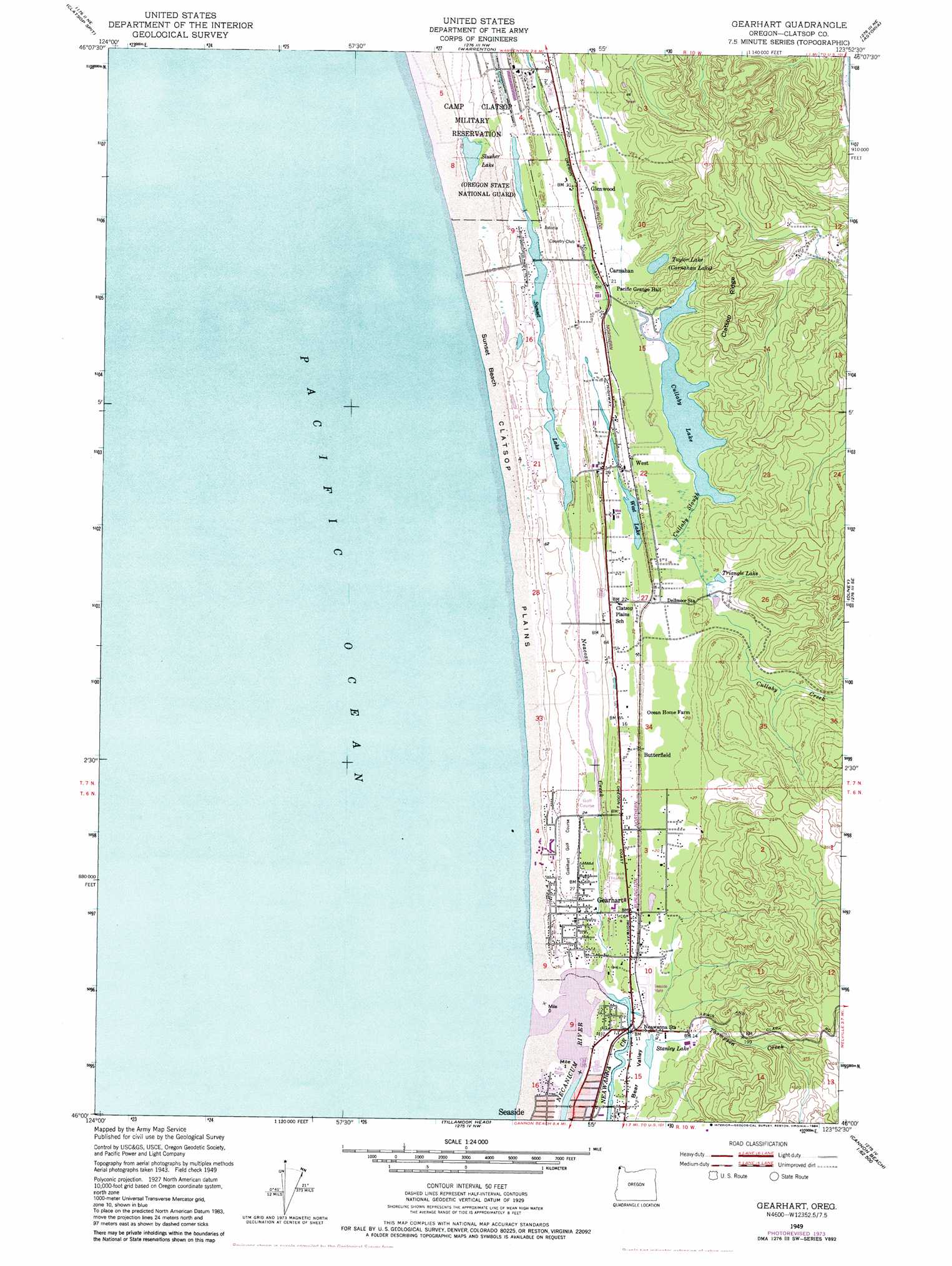
Gearhart Topo Map Oregon
To zoom in, hover over the map of Gearhart
USGS Topo Quad 46123a8 - 1:24,000 scale
| Topo Map Name: | Gearhart |
| USGS Topo Quad ID: | 46123a8 |
| Print Size: | ca. 21 1/4" wide x 27" high |
| Southeast Coordinates: | 46° N latitude / 123.875° W longitude |
| Map Center Coordinates: | 46.0625° N latitude / 123.9375° W longitude |
| U.S. State: | OR |
| Filename: | o46123a8.jpg |
| Download Map JPG Image: | Gearhart topo map 1:24,000 scale |
| Map Type: | Topographic |
| Topo Series: | 7.5´ |
| Map Scale: | 1:24,000 |
| Source of Map Images: | United States Geological Survey (USGS) |
| Alternate Map Versions: |
Gearhart OR 1949, updated 1955 Download PDF Buy paper map Gearhart OR 1949, updated 1965 Download PDF Buy paper map Gearhart OR 1949, updated 1976 Download PDF Buy paper map Gearhart OR 1949, updated 1978 Download PDF Buy paper map Gearhart OR 1949, updated 1984 Download PDF Buy paper map Gearhart OR 2011 Download PDF Buy paper map Gearhart OR 2014 Download PDF Buy paper map |
1:24,000 Topo Quads surrounding Gearhart
Cape Disappointment |
Chinook |
Knappton |
Rosburg |
|
Clatsop Spit |
Warrenton |
Astoria |
Cathlamet Bay |
|
Gearhart |
Olney |
Green Mountain |
||
Tillamook Head |
Necanicum Junction |
Saddle Mountain |
||
Arch Cape |
Soapstone Lake |
Hamlet |
> Back to 46123a1 at 1:100,000 scale
> Back to 46122a1 at 1:250,000 scale
> Back to U.S. Topo Maps home
Gearhart topo map: Gazetteer
Gearhart: Airports
Seaside State Airport elevation 8m 26′Gearhart: Beaches
Sunset Beach elevation 6m 19′Gearhart: Flats
Clatsop Plains elevation 8m 26′Gearhart: Lakes
Cullaby Lake elevation 8m 26′Slusher Lake elevation 7m 22′
Stanley Lake elevation 4m 13′
Sunset Lake elevation 9m 29′
Taylor Lake elevation 8m 26′
Triangle Lake elevation 9m 29′
West Lake elevation 8m 26′
Gearhart: Parks
Camp Cullaby elevation 9m 29′Carnahan County Park elevation 9m 29′
Cullaby Lake County Park elevation 9m 29′
Del Rey Beach State Park elevation 18m 59′
Gearheart Ocean State Park elevation 8m 26′
Sunset Beach State Park elevation 6m 19′
Sunset Lake Public Park elevation 9m 29′
Gearhart: Populated Places
Carnahan elevation 9m 29′Gearhart elevation 8m 26′
Sunset Beach elevation 9m 29′
Surf Pines elevation 11m 36′
Gearhart: Post Offices
Camp Clatsop Post Office (historical) elevation 18m 59′Clatsop Post Office (historical) elevation 9m 29′
Gearhart Post Office elevation 8m 26′
Gearhart: Ridges
Clatsop Ridge elevation 110m 360′Gearhart: Streams
Abercrombie Creek elevation 9m 29′Cullaby Creek elevation 8m 26′
Cullaby Slough elevation 8m 26′
Mill Creek elevation 4m 13′
Neacoxie Creek elevation 9m 29′
Neawanna Creek elevation 12m 39′
Necanicum River elevation 0m 0′
North Fork Abercrombie Creek elevation 9m 29′
Skookum Creek elevation 9m 29′
Thompson Creek elevation 1m 3′
Gearhart digital topo map on disk
Buy this Gearhart topo map showing relief, roads, GPS coordinates and other geographical features, as a high-resolution digital map file on DVD: