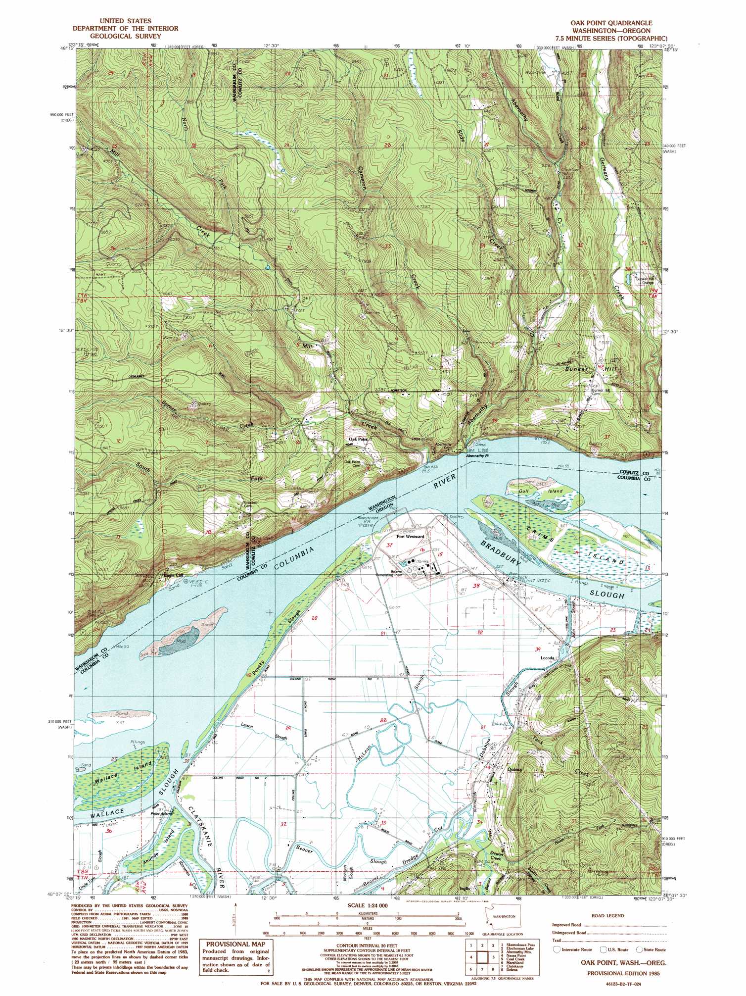
Oak Point Topo Map Washington
To zoom in, hover over the map of Oak Point
USGS Topo Quad 46123b2 - 1:24,000 scale
| Topo Map Name: | Oak Point |
| USGS Topo Quad ID: | 46123b2 |
| Print Size: | ca. 21 1/4" wide x 27" high |
| Southeast Coordinates: | 46.125° N latitude / 123.125° W longitude |
| Map Center Coordinates: | 46.1875° N latitude / 123.1875° W longitude |
| U.S. States: | WA, OR |
| Filename: | o46123b2.jpg |
| Download Map JPG Image: | Oak Point topo map 1:24,000 scale |
| Map Type: | Topographic |
| Topo Series: | 7.5´ |
| Map Scale: | 1:24,000 |
| Source of Map Images: | United States Geological Survey (USGS) |
| Alternate Map Versions: |
Oak Point WA 1985, updated 1985 Download PDF Buy paper map Oak Point WA 2011 Download PDF Buy paper map Oak Point WA 2014 Download PDF Buy paper map |
1:24,000 Topo Quads surrounding Oak Point
Blaney Creek |
Elochoman Pass |
Boistfort Peak |
Wildwood |
Winlock |
Skamokawa |
Skamokawa Pass |
Elochoman Lake |
Abernathy Mountain |
Castle Rock |
Cathlamet |
Nassa Point |
Oak Point |
Coal Creek |
Kelso |
Nicolai Mountain |
Marshland |
Clatskanie |
Delena |
Rainier |
Sager Creek |
Birkenfeld |
Pittsburg |
Baker Point |
Trenholm |
> Back to 46123a1 at 1:100,000 scale
> Back to 46122a1 at 1:250,000 scale
> Back to U.S. Topo Maps home
Oak Point topo map: Gazetteer
Oak Point: Bars
Eureka Bar elevation 7m 22′Memaloose Rock elevation 2m 6′
Oak Point: Capes
Abernathy Point elevation 2m 6′Oak Point (historical) elevation 3m 9′
Point Adams elevation 2m 6′
Oak Point: Channels
Eureka Channel elevation 2m 6′Eureka Upper Channel elevation 2m 6′
Eureka Upper Channel elevation 2m 6′
Gull Island Turn and Channel elevation 2m 6′
Oak Point Channel elevation 2m 6′
Oak Point: Guts
Bradbury Slough elevation 2m 6′Dobbins Slough elevation 6m 19′
John Slough elevation 5m 16′
Kinnunen Cut elevation 3m 9′
Michigan Slough elevation 6m 19′
Poysky Slough elevation 4m 13′
Oak Point: Islands
Anunde Island elevation 3m 9′Crims Island elevation 4m 13′
Gull Island elevation 4m 13′
Oak Point: Lakes
Swampy Lake elevation 4m 13′Oak Point: Populated Places
Bunker Hill elevation 145m 475′Eagle Cliff elevation 41m 134′
Inglis elevation 5m 16′
Oak Point elevation 98m 321′
Quincy elevation 25m 82′
Oak Point: Post Offices
Bradbury Post Office (historical) elevation 3m 9′Inglis Post Office (historical) elevation 5m 16′
Quincy Post Office (historical) elevation 25m 82′
Quinn Post Office (historical) elevation 4m 13′
Oak Point: Reservoirs
Quincy Reservoir elevation 108m 354′Oak Point: Streams
Abernethy Creek elevation 7m 22′Beaver Creek elevation 6m 19′
Beaver Slough elevation 2m 6′
Cameron Creek elevation 29m 95′
Cries Creek elevation 2m 6′
Larson Slough elevation 3m 9′
McLean Slough elevation 6m 19′
Mill Creek elevation 2m 6′
North Fork Mill Creek elevation 93m 305′
North Fork Stewart Creek elevation 31m 101′
Slide Creek elevation 26m 85′
South Fork Mill Creek elevation 29m 95′
Spruce Creek elevation 48m 157′
Stewart Creek elevation 5m 16′
Tank Creek elevation 7m 22′
Wiest Creek elevation 104m 341′
Oak Point: Trails
Mill Creek Truck Trail elevation 224m 734′Oak Point digital topo map on disk
Buy this Oak Point topo map showing relief, roads, GPS coordinates and other geographical features, as a high-resolution digital map file on DVD: