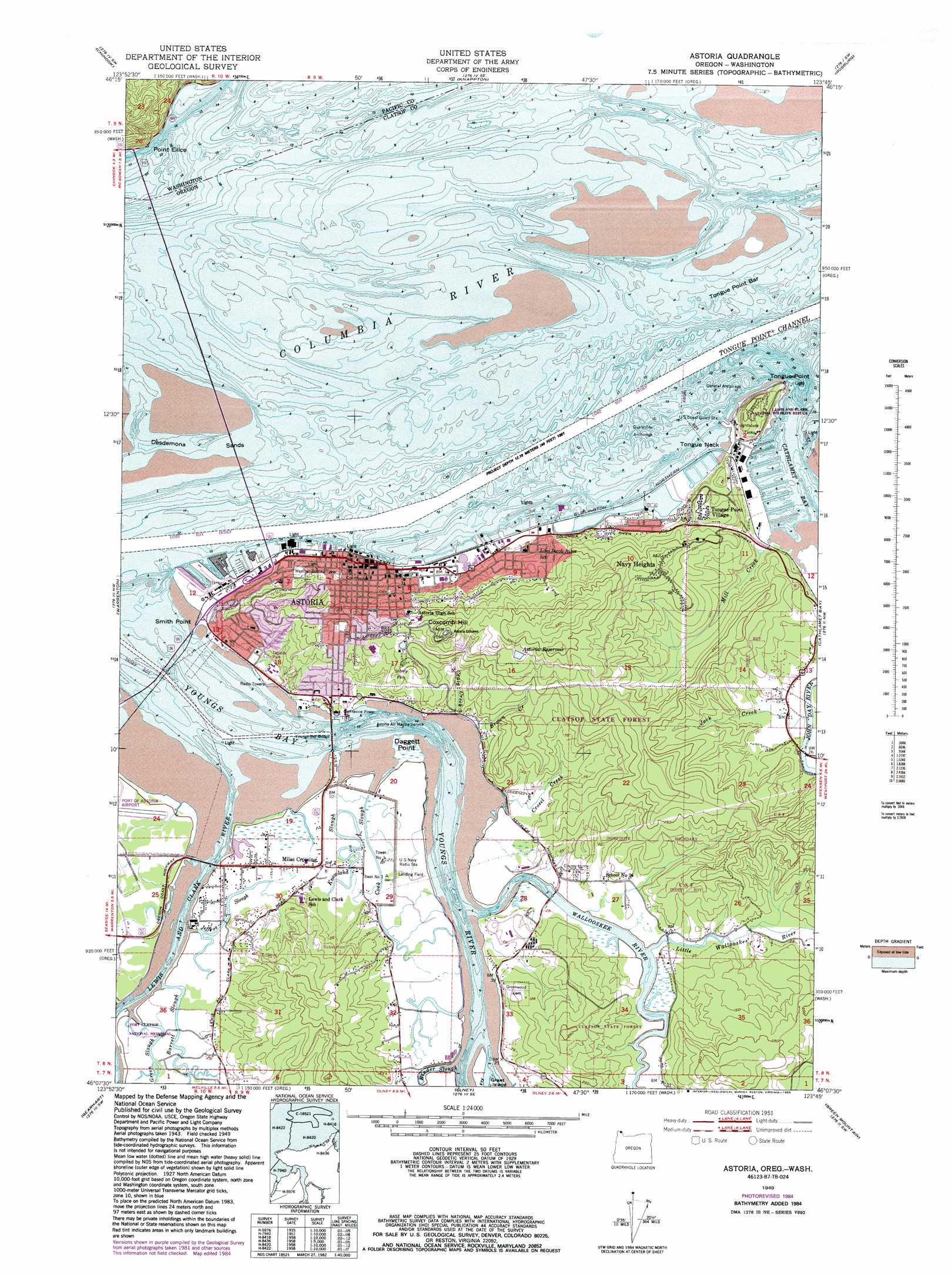
Astoria Topo Map Oregon
To zoom in, hover over the map of Astoria
USGS Topo Quad 46123b7 - 1:24,000 scale
| Topo Map Name: | Astoria |
| USGS Topo Quad ID: | 46123b7 |
| Print Size: | ca. 21 1/4" wide x 27" high |
| Southeast Coordinates: | 46.125° N latitude / 123.75° W longitude |
| Map Center Coordinates: | 46.1875° N latitude / 123.8125° W longitude |
| U.S. States: | OR, WA |
| Filename: | o46123b7.jpg |
| Download Map JPG Image: | Astoria topo map 1:24,000 scale |
| Map Type: | Topographic |
| Topo Series: | 7.5´ |
| Map Scale: | 1:24,000 |
| Source of Map Images: | United States Geological Survey (USGS) |
| Alternate Map Versions: |
Astoria OR 1949 Download PDF Buy paper map Astoria OR 1949, updated 1955 Download PDF Buy paper map Astoria OR 1949, updated 1968 Download PDF Buy paper map Astoria OR 1949, updated 1985 Download PDF Buy paper map Astoria OR 2011 Download PDF Buy paper map Astoria OR 2014 Download PDF Buy paper map |
1:24,000 Topo Quads surrounding Astoria
Ocean Park |
Long Island |
Oman Ranch |
Upper Naselle River |
Sweigiler Creek |
Cape Disappointment |
Chinook |
Knappton |
Rosburg |
Grays River |
Clatsop Spit |
Warrenton |
Astoria |
Cathlamet Bay |
Knappa |
Gearhart |
Olney |
Green Mountain |
Wickiup Mountain |
|
Tillamook Head |
Necanicum Junction |
Saddle Mountain |
Vinemaple |
> Back to 46123a1 at 1:100,000 scale
> Back to 46122a1 at 1:250,000 scale
> Back to U.S. Topo Maps home
Astoria topo map: Gazetteer
Astoria: Bars
Taylor Sands elevation 0m 0′Tongue Point Bar elevation 0m 0′
Upper Sands elevation 0m 0′
Astoria: Basins
Mott Basin elevation 23m 75′Astoria: Bays
Youngs Bay elevation 0m 0′Astoria: Bridges
Astoria Bridge elevation 0m 0′Lewis and Clark River Bridge elevation 1m 3′
Youngs Bay Bridge US-101 Alt elevation 0m 0′
Astoria: Capes
Daggett Point elevation 2m 6′Point Ellice elevation 77m 252′
Smith Point elevation 2m 6′
Tongue Neck elevation 5m 16′
Tongue Point elevation 19m 62′
Astoria: Channels
Astoria Range elevation 0m 0′Tongue Point Channel elevation 0m 0′
Astoria: Crossings
Astoria Megler Ferry (historical) elevation 0m 0′Astoria: Guts
Cook Slough elevation 5m 16′Astoria: Harbors
General Anchorage elevation 0m 0′Quarantine Anchorage elevation 0m 0′
Astoria: Islands
Fry Island elevation 1m 3′Astoria: Parks
Astoria Column elevation 172m 564′John Warren Field elevation 7m 22′
Shively Park elevation 81m 265′
Tapiola Park elevation 8m 26′
Astoria: Populated Places
Astoria elevation 7m 22′Jeffers Garden elevation 1m 3′
Miles Crossing elevation 6m 19′
Navy Heights elevation 109m 357′
Tongue Point Village elevation 41m 134′
Uniontown elevation 25m 82′
Astoria: Post Offices
Astoria Post Office elevation 6m 19′Lower Astoria Post Office (historical) elevation 1m 3′
Navy 10371 Post Office (historical) elevation 4m 13′
Navy 13027 Post Office (historical) elevation 5m 16′
Tongue Point Naval Station Post Office (historical) elevation 41m 134′
Upper Astoria Post Office (historical) elevation 5m 16′
Astoria: Reservoirs
Astoria Reservoir elevation 132m 433′Astoria Reservoir Number Two elevation 79m 259′
Knowland Slough elevation 5m 16′
Astoria: Streams
Barrett Creek elevation 8m 26′Barrett Slough elevation 2m 6′
Binder Slough elevation 1m 3′
Brown Creek elevation 2m 6′
Craig Creek elevation 2m 6′
Crosel Creek elevation 1m 3′
Green Slough elevation 1m 3′
Jack Creek elevation 1m 3′
Jeffers Slough elevation 1m 3′
John Day River elevation 1m 3′
Lewis and Clark River elevation 0m 0′
Little Wallooskee River elevation 2m 6′
Mill Creek elevation 4m 13′
Stewart Creek elevation 0m 0′
Wallooskee River elevation 1m 3′
Astoria: Summits
Coxcomb Hill elevation 172m 564′Astoria digital topo map on disk
Buy this Astoria topo map showing relief, roads, GPS coordinates and other geographical features, as a high-resolution digital map file on DVD: