Warrenton Topo Map Oregon
To zoom in, hover over the map of Warrenton
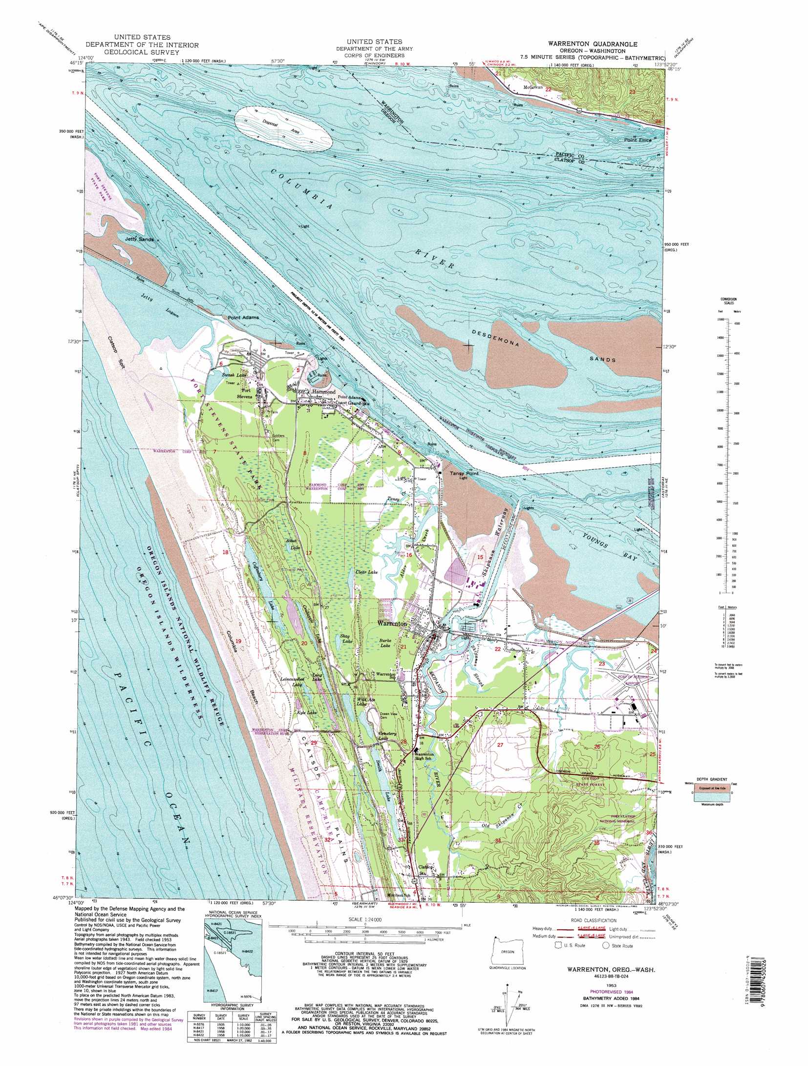
USGS Topo Quad 46123b8 - 1:24,000 scale
| Topo Map Name: | Warrenton |
| USGS Topo Quad ID: | 46123b8 |
| Print Size: | ca. 21 1/4" wide x 27" high |
| Southeast Coordinates: | 46.125° N latitude / 123.875° W longitude |
| Map Center Coordinates: | 46.1875° N latitude / 123.9375° W longitude |
| U.S. States: | OR, WA |
| Filename: | o46123b8.jpg |
| Download Map JPG Image: | Warrenton topo map 1:24,000 scale |
| Map Type: | Topographic |
| Topo Series: | 7.5´ |
| Map Scale: | 1:24,000 |
| Source of Map Images: | United States Geological Survey (USGS) |
| Alternate Map Versions: |
Warrenton OR 1953, updated 1955 Download PDF Buy paper map Warrenton OR 1953, updated 1965 Download PDF Buy paper map Warrenton OR 1953, updated 1976 Download PDF Buy paper map Warrenton OR 1953, updated 1982 Download PDF Buy paper map Warrenton OR 1953, updated 1985 Download PDF Buy paper map Warrenton OR 1953, updated 1985 Download PDF Buy paper map Warrenton OR 1996, updated 1999 Download PDF Buy paper map Warrenton OR 2011 Download PDF Buy paper map Warrenton OR 2014 Download PDF Buy paper map |
1:24,000 Topo Quads surrounding Warrenton
Ocean Park |
Long Island |
Oman Ranch |
Upper Naselle River |
|
Cape Disappointment |
Chinook |
Knappton |
Rosburg |
|
Clatsop Spit |
Warrenton |
Astoria |
Cathlamet Bay |
|
Gearhart |
Olney |
Green Mountain |
||
Tillamook Head |
Necanicum Junction |
Saddle Mountain |
> Back to 46123a1 at 1:100,000 scale
> Back to 46122a1 at 1:250,000 scale
> Back to U.S. Topo Maps home
Warrenton topo map: Gazetteer
Warrenton: Airports
Clatsop County Airport elevation 5m 16′Warrenton: Bars
Desdemona Sands elevation 0m 0′Jetty Sands elevation 0m 0′
Warrenton: Basins
Hammond Boat Basin elevation 0m 0′Warrenton: Bridges
Youngs Bay Bridge elevation 1m 3′Warrenton: Canals
Skipanon Waterway elevation 3m 9′Warrenton: Capes
Point Adams elevation 0m 0′Tansy Point elevation 1m 3′
Warrenton: Channels
Tansy Point Turn and Range elevation 0m 0′Upper Desdemona Shoal elevation 0m 0′
Warrenton: Dams
South Jetty elevation 0m 0′Warrenton: Lakes
Abbot Lake elevation 4m 13′Beaver Lake elevation 8m 26′
Cemetery Lake elevation 4m 13′
Clear Lake elevation 7m 22′
Coffenbury Lake elevation 6m 19′
Crabapple Lake elevation 9m 29′
Creep and Crawl Lake elevation 9m 29′
Jetty Lagoon elevation 0m 0′
Leinenweber Lake elevation 9m 29′
Long Lake elevation 12m 39′
Potato Lake elevation 8m 26′
Shag Lake elevation 4m 13′
Smith Lake elevation 4m 13′
Swash Lake elevation 1m 3′
Wild Ace Lake elevation 3m 9′
Warrenton: Parks
Battery Russell (historical) elevation 8m 26′Camp Kiwanilong elevation 9m 29′
Carruthers Memorial Park elevation 0m 0′
DeLaura Beach elevation 8m 26′
Fort Clatsop National Memorial (historical) elevation 6m 19′
Fort Stevens State Park elevation 7m 22′
Lewis and Clark National and State Historical Parks elevation 14m 45′
Smith Lake County Park elevation 7m 22′
Warrenton: Populated Places
Flavel (historical) elevation 2m 6′Fort Stevens elevation 8m 26′
Hammond elevation 4m 13′
McGowan elevation 5m 16′
Warrenton elevation 7m 22′
Warrenton: Post Offices
Flavel Post Office (historical) elevation 2m 6′Fort Clatsop Post Office (historical) elevation 1m 3′
Fort Stevens Post Office (historical) elevation 8m 26′
Graham Post Office (historical) elevation 2m 6′
Hammond Post Office elevation 4m 13′
Kindred Post Office (historical) elevation 9m 29′
Lexington Post Office (historical) elevation 6m 19′
Navy 10151 Post Office (historical) elevation 6m 19′
Port Clatsop Post Office (historical) elevation 2m 6′
Skipanon Post Office (historical) elevation 7m 22′
Warrenton Post Office elevation 7m 22′
Warrenton: Reservoirs
Kyle Lake elevation 16m 52′Warrenton: Streams
Adair Slough elevation 5m 16′Alder Creek elevation 3m 9′
Old Skipanon Creek elevation 8m 26′
Skipanon River elevation 0m 0′
Skipanon Slough elevation 0m 0′
Tansy Creek elevation 5m 16′
Vera Creek elevation 4m 13′
Youngs River elevation 0m 0′
Warrenton: Swamps
Brallier Swamp elevation 5m 16′Burke Lake elevation 8m 26′
Warrenton digital topo map on disk
Buy this Warrenton topo map showing relief, roads, GPS coordinates and other geographical features, as a high-resolution digital map file on DVD: